Shoreham or Newhaven?

If unsure, just land and ask a local.

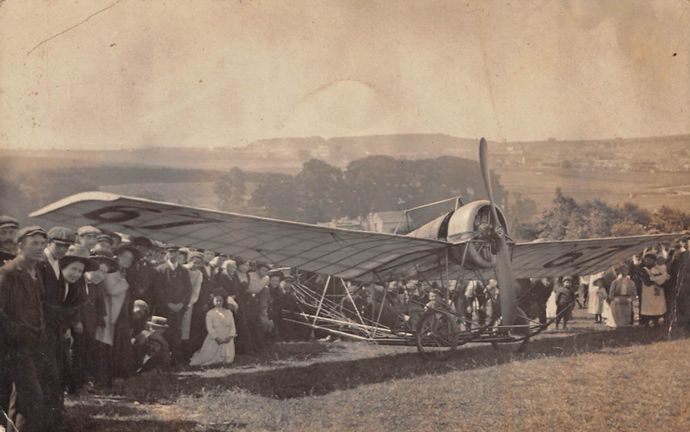
This photograph was unidentified until recently. It is of a daring early aviator Louis Emile Train who designed his own aircraft and competed in a number of races. The story behind this photograph is amazing. It should have been taken at Shoreham airfield at the penultimate stage of the Calais to London Air Race of 1911.

Unfortunately after flying over the English Channel heading to Shoreham before taking the last leg to Hendon Louis was presented with a challenge – what did Shoreham look like? He knew the Adur was a landmark, with Downs all around – but he came across Newhaven first and when Louis failed to find the aerodrome he decided the best approach would be to ask a local for directions. He put down his aircraft in a sloping field to the north of Newhaven.

Shoreham
Newhaven

He executed a difficult landing on a sloping field without incident, until the aircraft came to a halt – at which point it rolled backwards down the field. Unequipped with brakes the aircraft ended up in the field fencing and the tailplane was irreparably damaged. Louis was forced out of the race and never got to Shoreham.

The photos of the hubbub that ensued once the locals learnt of the unofficial French invasion and landing can be seen here.

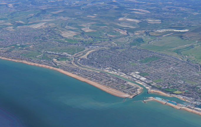
The location of the field at South Heighton is here.

Where is Shoreham’s Pickett-Hamilton?

There is a curiosity hidden deep in the plans and maps of Shoreham Airport… the previous existence of three WWII Pickett-Hamilton Defensive Forts. Are they still hidden under the grass and tarmac? Are they lost?

Pickett-Hamilton Retractable Fort, fully raised and manned, taken on an airfield in Southern England. RAF FIGHTER COMMAND, 1939-1945 © IWM (CH 17890) IWM Non Commercial Licence
Continue reading “Where is Shoreham’s Pickett-Hamilton?”

Ropetackle – the last 300 years

– a collection of images from the galleries and collections of shorehambysea.com illustrating the changes to the area since the 18th century.

What a wonderfully eccentric place it was! Besides a fascinating ropemaking and shipbuilding past there were, in Victorian times, ancient buildings still standing, quaint cottages, wharf houses, a gas works and, spookily, a mortuary alongside an incinerator! In the Little High Street there were peculiarly shaped houses and strange, shop-like windows.

It was never a fashionable area, being part industrial and part residential where the poorer, labouring families largely dwelt. In 1817 William Butler’s poor grammar  described it as being “the lower ‘hend’ of town” and goes on to mention a ‘pour new’ shop where he had ‘connections’ with Sarah Fillaps. Something of a mystery and perhaps a pawn shop (a corruption of the French ‘for us’) or as William’s escapades suggest one of the numerous brothels in Shoreham port then?

During the early part of the 19th century Ropetackle included wharf houses, sheds, a brickyard, coal yard, a bonding pond, Thomas Clayton’s deal yard, his cement factory, stables, a mixture of 17th to 19th century houses and even a mill pond. By the Victorian era there was also a sewage plant and of course the gasworks, flint-built ware houses, incinerator and mortuary. It all added to a certain air of eeriness and mystery to the area.

Continue reading “Ropetackle – the last 300 years”

Southlands – Workhouse and Hospital

Southlands Hospital – brief history

Southlands Hospital’s origin can be traced to the Steyning Union Workhouse that was built in a different location, at Ham Road, in central Shoreham in 1836. Later additions included infirmaries built in 1870, vagrant’s wards and a chapel. The union included parishes in East and West Sussex and the growth of population in its coastal areas meant that, despite much additional building, an enlarged site was required by the 1890s.

Continue reading “Southlands – Workhouse and Hospital”

HMS Dover

Naval sketches of the fourth rate, 48 guns,  three-decked man-of-war HMS Dover, built at Shoreham in 1653, give the impression of a very large ship. Surprisingly at 533 tons and keel length of 104 feet it was very similar in terms of length and tonnage to many of Shoreham’s typical 19th century home built merchantmen such as the Shamrock 500 tons/117 feet; Agricola 600 tons/119 feet and Cambria 500 tons/116 feet.


Visual comparisons perhaps give more idea of sizes and this view of an average 19th century vessel between the Dover (left) and the considerably larger Britannia (right, recorded at 800 tons and a length of 140 feet) reveals a perhaps diminutive but nevertheless beautiful example of Shoreham’s shipbuilding history.

1920’s Shoreham

An absolute cracker of a 1920’s photo of Ernie Butcher and Maude Paige, later to marry and become Portslade residents – but where in Shoreham is the location? (photo from Sharon Willard).

The building is Adur House located on the Brighton Road. (photo from Lofty)
This was demolished to make way for the new (now old) Civic Centre.

Clearing the Harbour

Top – two men digging aither side of a barge (1920’s Harbour Trustees photo). The aerial shot of similar period shows three barges together near the back of the Victory suggesting perhaps a permanent mooring and therefore a permanent function – e.g., the regular scouring of the mud flats by hand near that point.
The old dredgers were perhaps unable to operate away from the main channel even at high tide until they got through the locks. The photo shows the barge outside the round marker bouys of the main channel.
Even dredging by hand gradually between hightides (common in Victorian times) over a period of time may well have been effective “for shovelling away by navvies called muckshifters…..” until relatively recent times when dredgers had more efficient mechanisms and shallower draughts as the whole area there inside and outside of the old main channel seems now to be maintained at 1.9 metres.
Is that what is happening here …. or have they just grounded?

Rosalind mystery

In 1904 Stow & Sons completed the building of two sister yachts, the Rosalind and the Sylvia and the details for these are included in the list of Stow built yachts on this website  http://www.shorehambysea.com/stow-suter-yachts/

Recently we acquired an old postcard of a yacht moored outside Stow’s yard and on the reverse is written the date 26th August 1906. The vessel is without much doubt virtually identical to the Rosalind and Sylvia but there is no trace of Stow’s launching a yacht that year added to which Lloyds Registers Foundation have been kind enough to thoroughly check their records on our behalf and are able to categorically state that the completion/launch dates of the two yachts is definitely 1904.

Both yachts are still sailing and, even allowing for possible alterations in the years since, a comparison of the 1906 photo with the modern images reveals a number of similarities, most obvious of which are 1) the close proximity of the mizzenmast to the stern; 2) the mainmast is made up of two sections;  3) the spacing of the 1906 mainmast rigging where it meets the hull is equally spaced – all of which closely match the Rosalind more than the Sylvia (later renamed Mohawk II)

If it is the Rosalind why record a 1906 date on the back? Was it a mistake? Was it another, unrecorded vessel (highly unlikely)? Was there a regatta or other event that year that the Rosalind attended?