
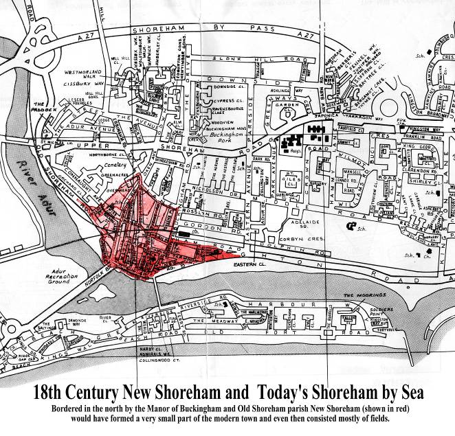
An Identification of the Present Day Locations of 1782 New Shoreham Buildings,Fields and Land using the 0riginal Survey Schedule and Map.
1782 Survey of New Shoreham
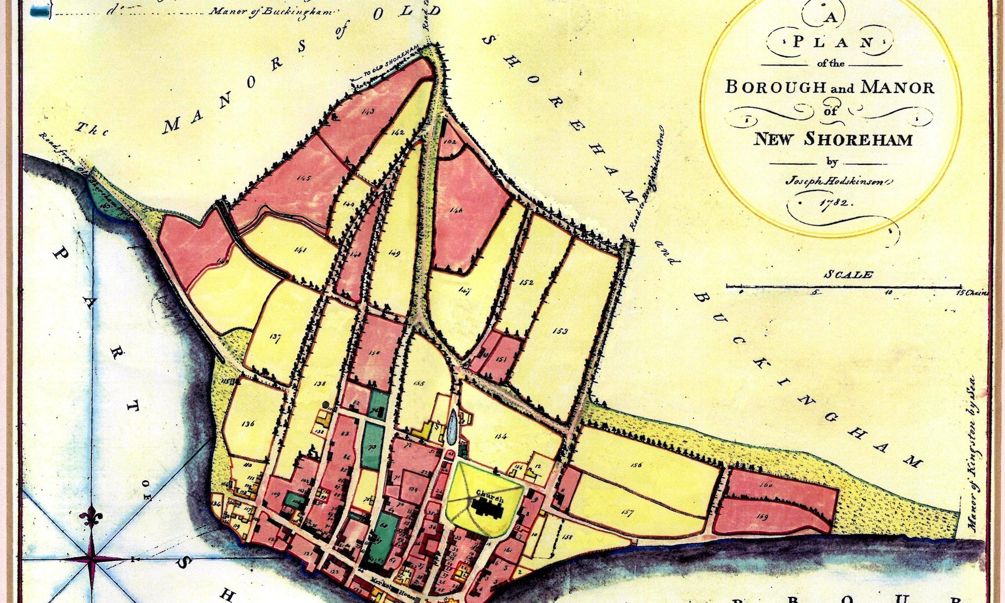
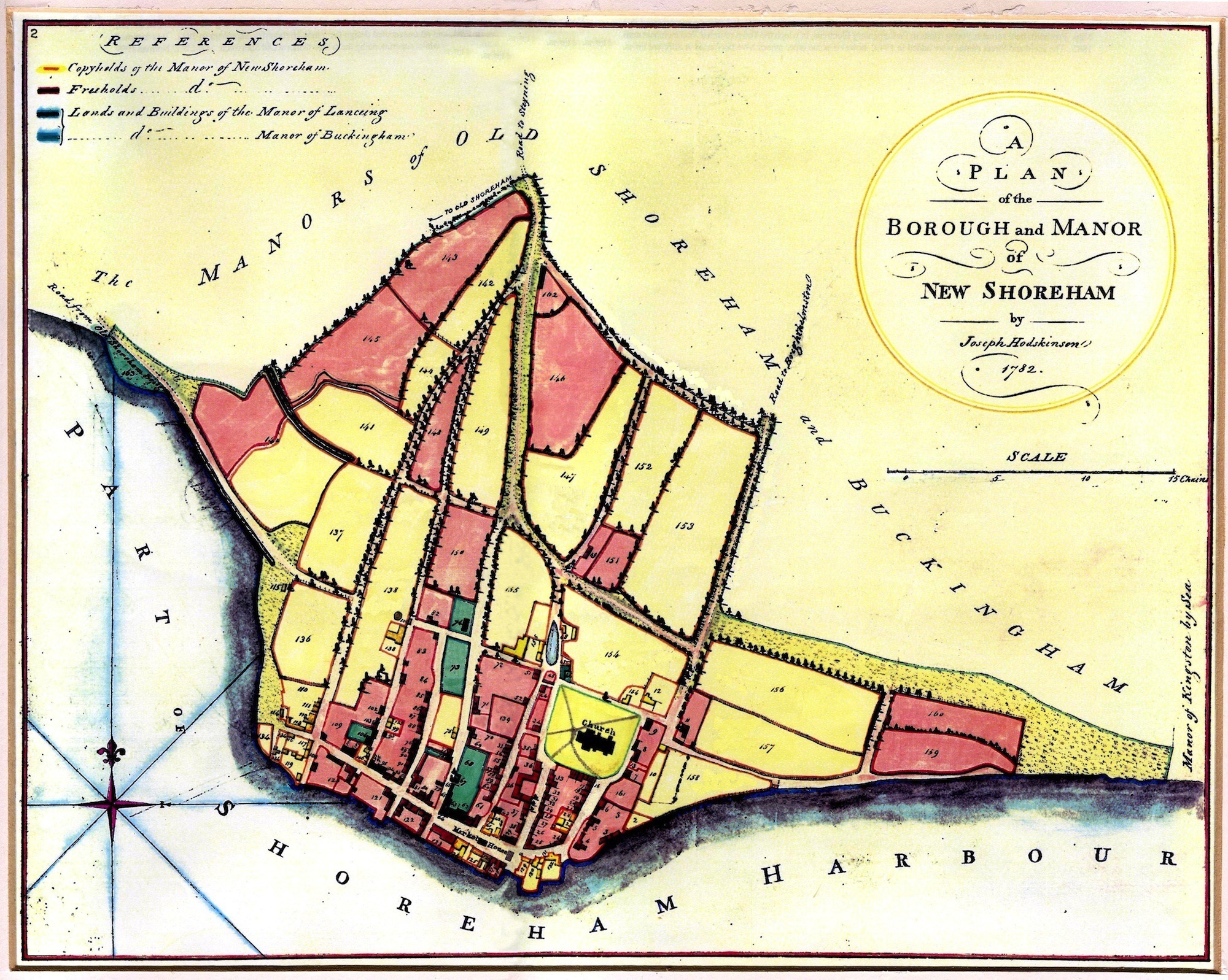
An identification of the land and properties, their owners and occupiers in New Shoreham using the original, numbered map and the Survey schedule describing the property and naming the owners. These have been matched to the Land Tax records for the same year to identify the occupiers. For ease of recognition the original order of the Schedule (no apparent order) has been rearranged into street order. To each entry for the owners has been added any subsequent changes in the months or years following that were made to the original Schedule, but unfortunately not dated, by the officials of the time. Where the Survey map is overlaid on to the modern map the buildings on them do not always exactly match as the former is not precisely drawn but nevertheless is still a useful aid to identification.
Roger Bateman
North Street
Shoreham
2008
LAND EAST OF BRUNSWICK ROAD AND EAST STREET
| Survey Number | Owner | Occupier | Description | Site Identification by Modern House Numbers or Area |
| 159 & 160 | W & F Dean later replaced by W.F.Ward | ? | Kings Arms Fields
Slaughter House and Stable |
Bordered by Ham Road, Brighton Road, Surrey Street and today’s Ham |
| 156 | John Innott | John Innott | Clubbs Hall Field | Bordered by Ham Road,
Surrey Street, and Brunswick Road southwards down to 18/20, Brunswick Road. |
| 157 | Frederick & W. Dean | Frederick Dean | Stone Croft, formerly Holden since Stow’s and late Roberts | Immediately below and
adjoining the above then continuing down the lower half of Brunswick Road to Tarmount Lane |
| 11 | W.Haselgrove later replaced by Partington | Ann Hazelgrove (and) Thomas Pelham (who) also rents the field | Tenement, garden, orchard workshops and stonemason’s yard part of Tarmount Fields | No’s 6 – 14 Brunswick Road |
| 158 | J.R.Hawkins | J.R.Hawkins | Fryers Field (actual spelling) and adjoining croft (the latter originally part of Fryers Field | Situated behind Chantry House (No.29 East Street) bordered by Tarmount Lane, New Road and its junction with Tarmount Lane |
| 10 | Nich.Roberts | Thomas Pockney (pp Land Tax) | Tenement and gardens formerly part of Fryers Field | A thin strip of land immediately behind Chantry House running from Tarmount Lane almost to New Road |
| 2 | W.Haselgrove later replaced by W.Bradley and Wm.Haselgrove | ?
Wm.Haselgrove |
Shop formerly Lowry’s, late Smith’s premises | No’s 12 – 14 New Road down to Brighton Road |
EAST STREET

EAST STREET – EAST SIDE
| Survey Number | Owner | Occupier | Description | Site Identification by Modern House Numbers or Area |
| 9 | J.A.Stow
Later replaced by Rice |
Mrs.Jemingson | Tenement and garden late Friths | No’s 35 – 36 |
| 8 | Nich.Roberts | Nich.Roberts | Tenement and garden late Lowdells | No’s 28 – 32 |
| 13 | Loftus Nunn
later replaced by Mrs.Amos |
Loftus Nunn
(Land Tax says J.R.Hawkins) |
A parcel of land part of a garden | Between No’s 27 & 28 |
| 7 | John Hawkins | John Roberts Hawkins | Tenement and garden | Chantry House No.27 |
| 161 | Rev.Mr.Marchant | ? | Parsonage Croft (Glebe) | No’s 24 – 25 |
| 1 | James Ather
J.R.Hawkins’ name added later |
James Ather | Tenement and yard called Tarmount House | The rear of No.22 |
| 6 | George Wilson | George Wilson | Tenement, garden and workshop | No’s 16 – 22 |
| 5 | James Lloyd, Esq., | Charles Hanington | Tenement and garden | No’s 12 – 14 |
| 4 | Rice
later replaced by John Lintott |
Dr.Sutcliff | Tenement and garden formerly Coopers late Widow Allens | No’s 4 – 6 |
| 3 | Robinson & Hanington | Empty
Ralph Moor Widow Mugridge |
Three tenements and gardens | Rear of East Street from New Road down to Brighton Road |
EAST STREET – WEST SIDE
| Survey Number | Owner | Occupier | Description | Site Identification by Modern House Numbers or Area |
| 15 | W.Haselgrove
later replaced by Partington |
Empty
Frances Cooper |
Two tenements and gardens | South-west corner of churchyard |
| 14 | Elizabeth Pelham later replaced by Burrows | James Courtney | Tenement and garden | No.20 |
| 16 | Richard Holland | ? | Tenement and garden | No.19 |
| 17 | Cave | ? | Tenement and garden | No.19 |
| 18 | Tasker | Mary Pelling | Tenement and garden | No.17 |
| 19 | Elizabeth Buckhole later replaced by John Innott | James Beach | Tenement and garden late Matthews | No’s 13 – 15 |
| 20 | Caleb Burrows (but Land Tax has Ann Haselgrove) | Caleb Burrows | Tenement and yard | No.11 |
| 21 | Samuel Shergold later replaced by Hanington | William Rusbridge | Tenement and Yard late Patchings | No.9 |
| 22 | Samuel Tuppen
John Innott added later |
Benjamin Button | Tenement and garden | No’s 7 – 9 |
| 23 | John Innott | John Innott | Tenement, brew house and mill house called Ludlows (Land Tax also suggests a vault here) | No.5 |
| 24 (part of) | John Snook | James Carver
Empty |
Two tenements and a workshop | No.3 (Ferry Arms) – the remainder is No’s 2 & 4 High Street |
CHURCH STREET
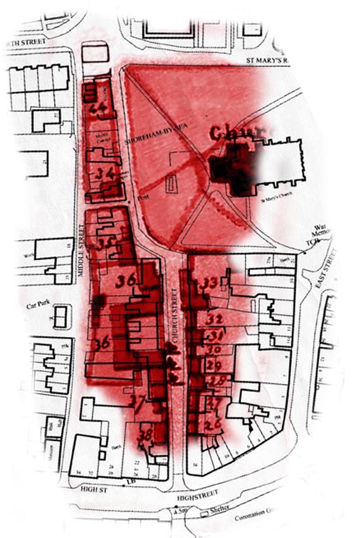
CHURCH STREET – EAST SIDE
| Survey Number | Owner | Occupier | Description | Site Identification by Modern House Numbers or Area |
| 26 | John Wood
Bradley entered later, then deleted, then Mrs. Moory entered in the margin |
William Hosegood
Ann Whalford |
Two tenements, backyard or garden | No’s 4 – 6 |
| 27 | Samuel Deane | Ann Lintott | Tenement and garden | No.8 |
| 28 & 29 | Siderick Elgar later replaced by Hill | Henry Partington
Widow Cheesman |
Two tenements and gardens late Rivetts | No’s 10 & 12 (28)
No.14 (29) |
| 30 | Henry Newton
J.Rice later entered in margin |
Richard Blair | Tenement and garden | No.16 |
| 31 | John Edwards
J.Rice later entered in margin |
William Fuller | Tenement and garden | No.18 |
| 32 | John Burton later replaced by Henry Innott | Thomas Snook | Tenement and garden | No.20 |
| 33 | John Butler | John Butler | Tenement and garden | No.22 |
CHURCH STREET – WEST SIDE
| Survey Number | Owner | Occupier | Description | Site Identification by Modern House Numbers or Area |
| 38 | George Brown
Later replaced by John Rice |
Thomas Mearsh | Tenement and back yard | No’s 3 – 7 |
| 37 | John Roberts, George Roberts and Mary Roberts | Empty
John Roberts Mrs.Foster John Pelham (Custom House) |
Three tenements, custom house, warehouse and backyard | No’s 9 – 15 |
| 36 | C.Bridger
(the ‘C’ later altered to ‘Hy’) |
Revd.Marchant
John Bridger Norton John Burton (Malthouse) |
Two tenements, malthouse, garden, stables, coach house and coach yard late Smiths | No’s 17 – 25 |
| 35 | John Snook | John Snook | Tenement, out house and garden | No’s 26 – 29 |
| 34 | Thomas Bennett
Later replaced by Carr |
Rice Jones | Tenement and garden | No’s 1 – 2 the Twitten up to and including No.30 |
| 44 | John Stent | John Stent | Tenement and garden | No’s 31 – 33
(currently just one property) |
| 45 | Clement Freeman later replaced by Rany(?) | ? | Tenement and garden | Later the site of Hutchins Place, currently ‘Westover’ between Church and Middle Streets facing Pond Road |
MIDDLE STREET
MIDDLE STREET – EAST SIDE
| Survey Number | Owner | Occupier | Description | Site Identification by Modern House Numbers or Area |
| 42 | John Pelham | Mathias Trusler
Thomas Salisbury |
Two tenements, backyard late Nicholas Roberts | Opposite Marlipins Museum Annexe/Hall |
| 43 | John Pelham, Esq., | ? | Warehouse | Opposite the rear entrance to Boots store (between the north end of Marlipins and number 3) |
MIDDLE STREET WEST SIDE
| Survey Number | Owner | Occupier | Description | Site Identification by Modern House Numbers or Area |
| 61 (northern half) | Ann Foster | Sarah Marshall or Jemima Stafford | Tenement | No’s 3 – 4 |
| 60 | William Bradford | William Newnum | Tenement and garden | No’s 5 – 5a |
| 59 | Sarah Purse
(Land Tax says John Purse later replaced by Tows or Jones) |
Richard Lashmar | Tenement and garden | No 6 (Royal Sovereign) |
| 58 | Charles Hanington | James Wensley | Tenement and garden late Sleach | Now part of car park and public toilets |
| 57 | Scutt
Later Jan…? Rondeau added |
Empty | Tenement and garden | Now part of car park and public toilets |
| Survey Number | Owner | Occupier | Description | Site Identification by Modern House Numbers or Area |
| 55 | William Cooter | Rising, Elizabeth Ather, William Cooter, William Waterman | Four tenements and gardens late Turpins | Now part of car park and public toilets |
| 54 | W & F Dean | Thomas Patchen
John Hogsflesh |
Tenement and garden | No 15 |
| 53 | Septimus Rickward
later replaced by Caleb Burrows |
Thomas Eatherton
Mrs Chapman |
Two tenements and gardens | No’s 16 – 17 |
| 70 (part of) | Richard Tillstone
later replaced by Thos. Tillstone |
Richard Tillstone | The warehouse on the east of Tillstone’s John Street property | No 18 |
| 139 | Thomas Fawler
later replaced by John Hooper |
William Deane
(pp Land Tax) |
Swan Croft | No 21 |
| 52 | Robinson and Hanington | Thomas Draper | Tenement and garden late Godleys | No 27 |
| 51 | Robinson and Hanington | Thomas Morley
William Stevens |
Two tenements and gardens late Golds | No 1 (North Street) |
JOHN STREET
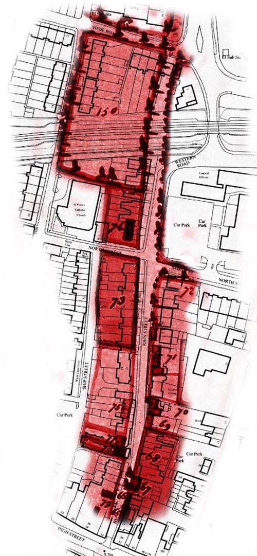 JOHN STREET – EAST SIDE
| Survey Number | Owner | Occupier | Description | Site Identification by Modern House Numbers or Area |
| 65 | John Edwards | Captain Higham | Tenement and back yard | No’s 4 – 6 |
| 66 | Elizabeth Bartlett | Widow Bartlett | Tenement and garden | No’s 8 – 10 |
| 67 | Thomas Worthing | ? | Tenement and garden | Chapel |
| 68 | Robinson and Hanington | ? | Croft of land now a garden | No’s 16 – 26 |
| 69 | John Shelley
later replaced by Thos. Elgar |
Robert Grover | Tenement and garden | No 28 |
| 70 (part of) | Richard Tillstone
later replaced by Thos. Tillstone |
Richard Tillstone | Tenement, garden and warehouse (warehouse on the east in Middle Street) | No’s 30 – 32 |
| 71 | Thomas Fawler
later replaced by John Hooper |
Empty, George Sawyers, Samuel Sawyers | Three tenements, stable and garden | St.John’s Cottages, No 34 (St.John’s House) and No’s 1 – 3 St. John’s Mews |
| 72 | Ann Foster
later replaced by John Foster |
? | Garden | No’s 36 – 44 John Street and No’s 7 – 11 North Street |
JOHN STREET – WEST SIDE
| Survey Number | Owner | Occupier | Description | Site Identification by Modern House Numbers or Area |
| 79 (part of) | John Wood | John Wood | Tenement, back yard, garden and workshop | Part of property at No’s 54 – 56 High Street extending north to and including No 5b John Street |
| 78 | Henry Robinson | ? | Tenement and garden | No 6 (the disused Roman Catholic church) |
| 77 | Ann Bennett | Ann Bennett | Tenement and garden | No 7 |
| 75 | Siderick Elgar
later replaced by John Boyce then Cave and J.Tillstone |
Robert Trower
Widow Rusbridge |
Two tenements and gardens late Hards (property later split and amended to:- Cave, John Boyce jr, tenement and garden late Elgars. Edward Tate tenement and garden late Elgars) | No’s 9 – 23 |
| 73 | Harry Innott later replaced by John Innott | ? | Garden | No’s 25 – 43 up to the junction with North Street |
| 74 | Waugh | Empty, Thomas Puttick | Two tenements and gardens | No’s 45 – 53 |
| 150 | J.B.Norton
later replaced by James Wiston, Thomas Frost, then William Frost |
J.B. Norton | Field | A field bounded by today’s Hebe Road to the north, West Street to the west and John Street to the east down to No. 29 John Street. The railway line now occupies most of the top half of the field and in its south west corner are No’s 55 – 63 John Street |
SHIP STREET
 SHIP STREET – EAST SIDE
| Survey Number | Owner | Occupier | Description | Site Identification by Modern House Numbers or Area |
| 81 (part of) | John Pelham | (see High Street entry for 81) | Tenement, malthouse and stable | From No 2 up to the rear of the old R.C. church (remainder at No’s 60 – 62 High Street) |
(The remainder of the east side of Ship Street northwards is the west side of Survey No’s 78, 77, 75 and 73 that have already been
described in the John Street details and today are the old front of the R.C. church and the back gardens of John Street properties)
SHIP STREET – WEST SIDE
| Survey Number | Owner | Occupier | Description | Site Identification by Modern House Numbers or Area |
| 91 | John Edwards
later replaced by Rice |
John Edwards
Empty |
Two tenements and gardens | No’s 1 – 3 |
| 90 | Rev Marchant | Harry Haylor | Tenement and garden | No’s 5 – 9 |
| 89 | John Hall | Samuel Wilson | Tenement and garden | No 11 |
| 76 | Nathan Hall
later replaced by L. Sayers |
John Barnard
Empty |
Two tenements and gardens late Hards | No’s 13 – 15 |
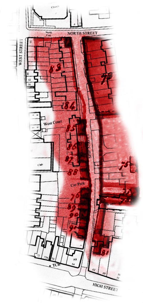
| 88 | Sheppard | ? | Two tenements and gardens | No’s 17 – 18 |
| 87 | See below | See below | Tenement and garden | No’s 21 – 22 |
There is no owner or occupier entered for 87, only the Schedule number and description – it is entered after 86 and 85 (below) and could
possibly be the same owner (Stow). This is supported by Land Tax details for James Stow and shows three occupants which match the total number of tenements for 85, 86 and 87
| Survey Number | Owner | Occupier | Description | Site Identification by Modern House Numbers or Area |
| 86 | Daniel Stow later replaced by William Haylor | Widow Broad, James Stow and Thomas Hogsflesh (for 85,86 and 87) | Tenement and garden | No 23 |
| 85 | Stow
later replaced by John Ratcliff |
See above | Tenement and garden late Beachers | No’s 25 – 26 |
| 84 (part of) | This is the east side of the plot which has its buildings on the west side in West Street and is included with the latter | No’s 28 – 30 | ||
| 83 (part of) | This is the eastern half of the plot in West Street and is included with the latter | No 31 up to North Street | ||
WEST STREET
WEST STREET – EAST SIDE
| Survey Number | Owner | Occupier | Description | Site Identification by Modern House Numbers or Area |
| 98 | John Pelham | ? | Workshop | No’s 10 – 12 |
| 99 | John Pelham later replaced by Ann Foster, Cheesman and Tate | ? | Tenement and garden called Millhouse | No 14 |
| 135 | Hammond
J.R.Hawkins added later |
? | Tenement and garden | No 16 |
| 84 (part of) | Henry Innott later replaced by John Innott | ? | Tenement and garden late Thomsetts | No’s 24 – 26 (the eastern end of this plot is in Ship Street) |
| 83 | James Stow later replaced by Ratcliff | ? | Orchard and stable | No’s 28 – 54 |
| 82 | John Egden | John Egden
William Head |
Two tenements and gardens late Guildfords | The land now covered by the (new) R.C. church |
| 150 | Extending from the railway line up to Hebe Road and already included and described with John Street | |||
WEST STREET – WEST SIDE
| Survey Number | Owner | Occupier | Description | Site Identification by Modern House Numbers or Area |
| 105 | Nicholas Tillstone
Thomas Tillstone added later |
? | Tenement and garden late Holdens | No 5 |
| 104 | Reed,Esq., | John Wolf | Freehold tenement, garden and stable | No 7 |
| 103 | John Edwards
(Land Tax still shows owner as Ann Foster – see ‘Description’) |
Sarah Marshall
Jemima Stafford |
Two tenements and gardens late Fosters | No 9 and part of No 11 |
| 102 | Thomas Fawler later replaced by John Hooper | Benjamin Tillstone | Tenement and garden | No’s 15 – 17 |
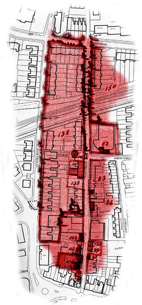
| 138 | Thomas Fawler formerly Thomas Pools later replaced by John Hooper | Thomas Hanington | Bayfield and Ropewalk Field with warehouses, gardens and premises adjoining formerly known by the names of Dukes Croft, Lords Garden and a piece of waste | Land between West Street and Victoria Road bounded on the north by Hebe Road and on the south by 23 West Street |
| 100 | Richard Tillstone later replaced by James Tillstone | ? | Rope warehouse erected on the waste by Piercy for which a grant was never obtained from the Lord | The rope winding house that stood in the road outside No’s 59 – 61 |
HIGH STREET
(North and south sides described alternately from the eastern end [East Street] to the western [Norfolk Bridge] end)
HIGH STREET – EASTERN HALF
North side of High Street between East and Church Streets
| Survey Number | Owner | Occupier | Description | Site Identification by Modern House Numbers or Area |
| 24 (part of) | John Snook | James Carver
Empty |
Two tenements and a workshop | No’s 2 – 4, the remainder being No 3 East Street (Ferry Arms) |
| 25 | John Pelham, Esq., | John Boyce | Star Inn, stables and stable yard | No’s 6 – 16 |
South side of High Street from eastern (footbridge) end of Coronation Green to its western end (Star Gap)
| 132 | Elizabeth Firth, Hugh Roberts and Thomas Hanington later replaced by James Newnum in trust for Ruth Smith’s children | Thomas Hanington | Dolphin Inn, stables and backyard late Osborne | Easternmost third of Coronation Green and extending into the High Street |
| 131 | Thomas Hanington later replaced by James Newnum then Thomas Smith | John Hanington | Tenement and back yard with a brewhouse and wharf part of which is an encroachment not yet taken cognizance of in court | Northernmost half of centre third of Coronation Green and extending into the High Street |
| 130 | Henry Hanington | Henry Hanington | Tenement and warehouse late Sargents (a later entry for this schedule number under the same ownership adds ‘Tenement late Dunton’s’) | Southernmost half of centre third of Coronation Green |
| Survey Number | Owner | Occupier | Description | Site Identification by Modern House Numbers or Area |
| 129 | John Boyce
(a later entry of ‘John Innott late Humphrey Paine’ was deleted) |
John Pelham | Warehouse called ‘High Cage’ and coal pens adjoining called Close Walls, late Paines. | Westernmost third of Coronation Green and extending into the High Street |
Land Tax records also show John Innott as being the owner and occupier of the ‘cellar under High Cage’ The name ‘High Cage’ derives from the name for a brazier on the end of a boom used for guiding ships into dock.
North side of High Street between Church and Middle Streets
| 39 | Ann Foster later replaced by John Foster | Elizabeth Stanes
William Violet William Deane |
Three tenements and a shoemaker’s shp late Stones | No’s 18 – 26 |
| 40 | John Pelham later replaced by Henry Roberts then Nicholas Roberts | John Pelham
Empty |
Tenement and garden late Olivers | No’s 28 – 30 |
| 41 | This survey number appears on the map but is missing from the schedule list entirely. It is suggested (by the researcher) that the two matched Land Tax occupant entries for 40 (‘John Pelham’ and ‘Empty’) are in fact for both 40 and 41. These are described in the Land Tax as a Red Herring House (i.e. for fish smoking) and Malthouse and are thought to be part of the long building that stretched up Middle Street from behind 34 High Street. | No’s 32 – 34 | ||
South side of High Street from Star Gap up to and including the Crown and Anchor (opposite Middle Street)
| Survey Number | Owner | Occupier | Description | Site Identification by Modern House Numbers or Area |
| 128 | Henry Robinson later replaced by John Roberts Hawkins | James Turner
Henry Robinson Benjamin Ashman |
Two tenements and back wharf
Tenement and back wharf |
No’s 23 – 25 (Stone House)
No 27 |
| 126 | John Burton later replaced by Elizabeth Burton then Bradley | John Partington | Tenement, warehouse and back wharf | No’s 29 – 31 |
| 125 | James Legg later replaced by John Innott | Thomas Bennett | Tenement and garden | No 33
(Crown and Anchor) |
North side of the High Street between Middle and John Streets
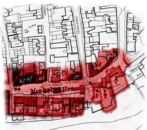
| 61 | Ann Foster later replaced by John Foster | Sarah Marshall, Jemima Stafford, John Pelham (Marlipins) | Two tenements, warehouse and garden late Newnhams | Marlipins Museum, Marlipins pub and up to and including No’s 3 – 4 Middle Street |
| 62 | Robinson and Hanington | Thomas Jennings
Robert Grover |
Two tenements and gardens | No’s 40 – 42 |
| 63 | James Newnham | James Newnham | Tenement and garden | No’s 44 – 46 |
| 64 | In dispute between Tuppen and Deane (Land Tax shows Tuppen as owner) | Elizabeth Pelham | Tenement and garden | No’s 48 – 52 |
South side of High Street opposite Middle Street up to and including the old Customs House/Town Hall opposite John Street
| Survey Number | Owner | Occupier | Description | Site Identification by Modern House Numbers or Area |
| 124 (i) see below | John Roberts now Widow Roberts to which were subsequently added Henry Roberts then Nicholas Roberts | ? | Tenement late Tuppins | No’s 37 – 39 |
| 124 (ii) see below | Susannah Roberts | Susannah Roberts
Widow Brookfield |
Two tenements and a back yard | No’s 37 – 39 |
| 123 | Thomas Fawler later replaced by John Hooper | Clement Freeman | Tenement, garden, coach house and warehouse | No’s 41 – 45
(This was the old Poole mansion house that was demolished in the 1830’s and part replaced by the Custom House/Town Hall) |
(Re.124 – there are two entries in the schedule for this same number. The second one (ii) may be in part a duplication as it has subsequently been deleted but both are included here as there are differences between the two)
HIGH STREET – WESTERN HALF
North side of the High Street between John and Ship Streets
| Survey Number | Owner | Occupier | Description | Site Identification by Modern House Numbers or Area |
| 79 | John Wood
Bradley added later but then deleted |
John Wood | Tenement, back yard, garden and workshop | No’s 54 – 56 continuing up to and including No 5b John Street |
| 80 | Sarah Geere | Sarah Geere | Tenement and garden | No 58 |
| 81 | John Pelham | Thomas Hollingham (Tenement and malthouse)
JamesMichell |
Tenement, malthouse and stable | No’s 60 – 62 continuing up to but not including the Roman Catholic church in Ship Street |
South side of the High Street opposite the area between John and Ship Streets
| 122 | Robinson and Hanington later replaced by Henry Robinson | William Austin
Nathaniel Hillman Widow Boyer Thomas Robinson John Martin Empty William Greatwick |
Eight tenements, ship building yard and blacksmiths shop late Collings
(NB only seven tenements indicated in ‘Occupier’ record) |
No’s 51 – 61 but projecting into High Street |
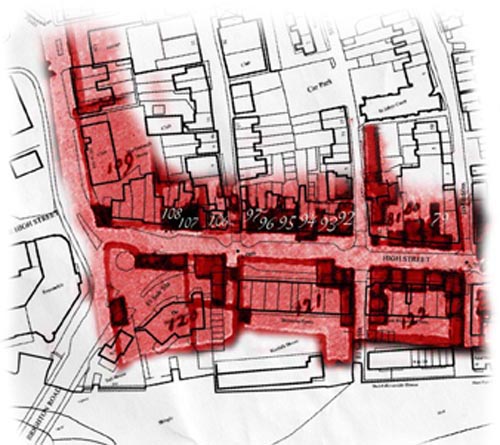
North side of the High Street between Ship and West Streets
| Survey Number | Owner | Occupier | Description | Site Identification by Modern House Numbers or Area |
| 92 | Elizabeth Lashmar | Elizabeth Lashmar | Tenement and yard | No 64 |
| 93 | Ann Daniel
(two later entries illegible) |
Ann Daniel | Tenement and yard | No 66 |
| 94 | John Smith later replaced by John Ford ( a subsequent replacement is illegible) | John Smith | Tenements and yard | No’s 68 – 70 |
| 95 | Robinson and Hanington John Monkhouse added later | Siderick Elgar | Tenement and garden late Dyers | No’s 72 – 72c |
| 96 | Elizabeth Holden
(Land Tax shows John Holden) |
John Holden | Tenement and garden | No 74 |
| 97 | James Miller | James Miller | Tenement and garden | No 76 |
South side of the High Street opposite the area between Ship and West Streets
| Survey Number | Owner | Occupier | Description | Site Identification by Modern House Numbers or Area |
| 121 | Robinson and Hanington later replaced by Henry Robinson then Edwards | William Cooter
Empty Widow Lasseter |
Three tenements, shop, building yard, warehouse and other premises late Strattons | No’s 63 – 77 but projecting more into the High Street |
North side of the High Street between West Street and where the High Street turns north towards the Old Shoreham Road
| 106 | Thomas Pelham
‘Brown’ added later but then deleted with additional wording ‘corr. Brown an infant’ |
John Parsons | Barbers shop and coalhouse part of a garden late Holdens formerly Nyes | No’s 78 – 80 |
| 107 | John Boyce | Napper Daniel | Tenement and yard late Glasspools | No 82 |
| 108 | Cooter and Lasseter later replaced by B.Tilstone then Austin | Martha Chandler | Two tenements and garden late Athers | No’s 84 – 86 |
| 109 | Henry Robinson | Richard Harris | Tenement and three gardens | No’s 88 – 96 |
South side of the High Street between the access road opposite West Street to the east side of Norfolk Bridge
| Survey Number | Owner | Occupier | Description | Site Identification by Modern House Numbers or Area |
| 120 | Henry Innott | Henry Innott | Tenement, blacksmiths shop *, building yard and premises | Detached shop, Bridge Hotel and old Toll House but extending well into the High Street and today’s roundabout. |
* Land Tax shows Napper Daniel (occupier of schedule number 108) also as occupier of the smiths shop here but with Innott and Pelham as joint owners
ROPETACKLE
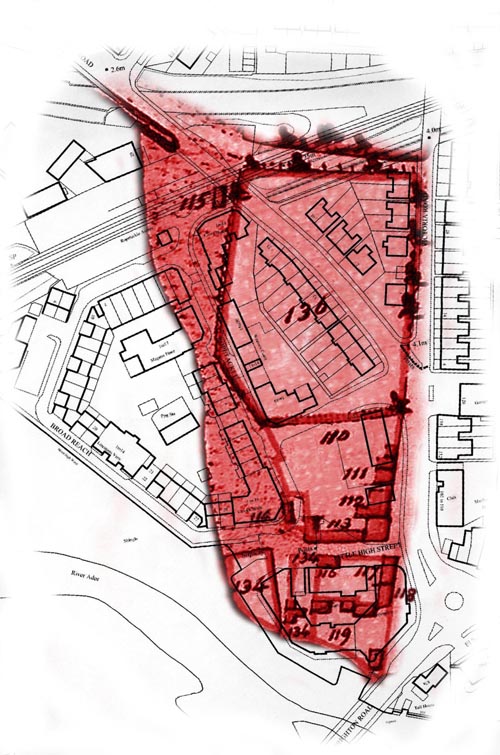
West side of the Norfolk Bridge northwards up to Little High Street
| Survey Number | Owner | Occupier | Description | Site Identification by Modern House Numbers or Area |
| 119 | Richard Tillstone later replaced by Thomas Tillstone | John Sawyer (cottage)
(NB Land Tax shows Benjamin Tillstone as owner and occupier of the cottage and complete site) |
Cottage, shipbuilding yard, warehouse and premises | Southern part of the Arts Centre in the Ropetackle development |
| 134 | James Newnum | ? | Warehouses, garden and plot of ground called Mill Green consisting of Windmill Plot, cottage adjoining the plot, parcel of land now called a garden, messuage and gardens | Western part of the Ropetackle residential block adjoining the Arts Centre |
| 118 | James Wisdom
Benjamin Tillstone added later |
Empty | Tenement and garden | Centre portion of the Arts Centre |
| 117 | Thomas Hanington later replaced by Henry Hanington then James Newnum | Richard Carpenter | Tenement and garden late Mooney | Eastern end of the north part of the Arts Centre |
| 116 | Colvill Bridger, Esq.,
Harry Bridger added later |
William Hassell | Tenement and garden | Western end of the above |
From the Little High Street up to the Ropetackle access road opposite the south end of Victoria Road
| Survey Number | Owner | Occupier | Description | Site Identification by Modern House Numbers or Area |
| 113 | Samuel Harris, Esq.,
John Butler added later |
Empty | Tenement, warehouse and backyards late Ryders | Westwards from the north eastern corner of Little High Street halfway to the hard |
| 112 | John Innott | ? | Tenement and garden
– part called Bell Yard late Athers – part late Wolvens, formerly Grovers |
Opposite No 102 High Street (southern part of Marlborough House) |
| 111 | Friend Daniel later replaced by Richard Carpenter then William Ratcliff | Empty
Empty |
Two tenements and garden late William Daniels | Opposite the northern part of Marlborough House and 112 High Street |
| 110 | William Deane later replaced by Richard Francis Ward | ? | Orchard and stable called Dyers Garden | Opposite 114 High Street up to the Ropetackle access road and westwards to Carrick Walk |
| 114 | Innott and Pelham
John Boyce added later |
? | An enclosed sawpit erected on the waste, late Hows | Immediately north of the hard at Ropetackle |
| 136 | Thomas Fawler formerly Thomas Pools later replaced by John Hooper | Thomas Hanington | Lower Ropetackle Field | Northwards from the Ropetackle access road up Victoria Road to the railway bridge then west along the railway line to just beyond the Old Shoreham Road railway bridge (this field is now traversed by the Old Shoreham Road) |
| 115 | Innott and Pelham later replaced by John Boyce then B.Tillstone | ? | An enclosed sawpit on the waste | On the site of the railway line just west of the Old Shoreham Road railway bridge |
FIELDS AND LAND ABOVE THE RAILWAY LINE BETWEEN THE OLD SHOREHAM ROAD AND VICTORIA ROAD
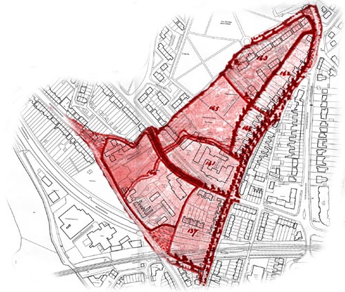
| Survey Number | Owner | Occupier | Description | Site Identification by Modern House Numbers or Area |
| 137 | Thomas Fawler formerly Thomas Pools later replaced by John Hooper | Thomas Hanington | Upper Ropetackle Field | From the railway line northwards up Victoria Road to Swiss Gardens along to No 4 then southwards down to the Old Shoreham Road railway bridge |
| 140 | John Edwards later replaced by Rice | ? | A meadow embanked in 1782 | From the Old Shoreham Road railway bridge northwards along the Old Shoreham Road to No 81, eastwards to No 5 Connaught Avenue, south east to No 4 Swiss Gardens and back down to the Old Shoreham Road railwaybridge |
| 141 | John Edwards later replaced by R.F.Ward | ? | David’s Marsh | The land now containing the Swiss Gardens Primary School and playing field |
| 145 | C.Bridger later replaced by Henry Bridger | ? | Meadow with green bank adjoining | Bounded by No’s 5 – 11 Swiss Gardens northeastwards halfway along the southeastern boundary of the cemetery, along the top and down the east side of the Meads Allotments boundary, back across the top of Swiss Gardens school playing field then south back to
No 5 Swiss Gardens |
| 144 | Richard Tillstone later replaced by Thomas Tillstone | ? | Little Dam Field | The houses and gardens of No’s 45 – 77 Victoria Road |
| Survey Number | Owner | Occupier | Description | Site Identification by Modern House Numbers or Area |
| 143 | Richard Tillstone later replaced by Thomas Tillstone | ? | Meadow late Bartletts | From the top of the allotments northeastwards along the cemetery boundary to Mill Lane then down and around the east side of Overmead back to the allotments |
| 142 | John Edwards later replaced by Henry Roberts then Susan Roberts, then John Boyce jr. then Rice | ? | A field formerly Coles late Roberts | The houses and gardens of
No’s 79 – 95 Victoria Road, No’s 53 – 59 Mill Lane and No’s 1 – 2 Overmead |
FIELDS AND LAND ABOVE THE RAILWAY LINE BETWEEN VICTORIA ROAD AND BUCKINGHAM ROAD
(A good example of how the original field boundaries are reflected by streets, even where the railway line has traversed fields e.g., 153)
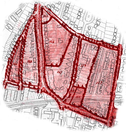
| Survey Number | Owner | Occupier | Description | Site Identification by Modern House Numbers or Area |
| 148 | Henry Robinson | Charles Hanington | Field | Bounded by Hebe Road, Victoria Road and Ropewalk |
| 149 | John Pelham later replaced by Ann Foster, widow, Cheesman and Tate | John Pelham | Field called Long Croft | Bounded by Hebe Road, Ropewalk/Victoria Road and Southdown Road |
| 162 | C.Bridger later replaced by Henry Bridger | No entry on schedule but Land Tax records show C. Bridger ‘occupying’ all three houses | Three tenements and gardens | The three terraced cottages No’s 44 and 46 Southdown Road and 9a Mill Lane |
| 146 | C.Bridger later replaced by Henry Bridger | John Boyce | New Barns Field | Bounded by No’s 12 – 36 Southdown Road, northeastwards to 9 Mill Lane then down and along the access lane below 7 Mill Lane to the rear garden of 12 Southdown Road |
| 147 | Colvill Bridger, Esq., later replaced by Henry Bridger | John Boyce | Wickers Field | Bounded by Southdown Road from No 10 southwards down to Ravens Road, back up to Mill Lane into and along the access lane to return to the rear garden of 10 Southdown Road |
| 152 | James Stow
Mary Roberts and Athor Stow added later but then deleted, then finally Rice |
? | Field | Bounded by No 10 Ravens Road northwards to and along Mill Lane to the rear gardens of Queens Place, then southwards behind these gardens to the rear garden of 10 Ravens Road |
| Survey Number | Owner | Occupier | Description | Site Identification by Modern House Numbers or Area |
| 153 | Mary Connack formerly widow Bowyer (Elizabeth Burton and R.F.Ward added later) | John Boyce | A field in the occupation of J.Boyce | Bounded by the rear gardens of Queens Place on the west side, then Mill Lane, Buckingham Road and Western Road |
| 49 | John Pelham, Esq., | John Pelham
Empty |
Two tenements, orchard and garden | Approximately the width of, and running southwards down, the front gardens of No’s 2 – 8 Ravens Road to the road end. |
| 151 | Ann Foster later replaced by John Foster | ? | Stone Croft | Abutting and matching the length of schedule number 49 plot but extending in width from 49 to the rear gardens of Queens Place |
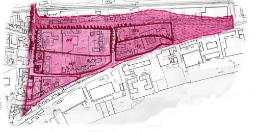
FIELDS AND LAND BOUNDED BY THE JUNCTION OF HEBE ROAD WITH SOUTHDOWN ROAD, WESTERN ROAD, BRUNSWICK ROAD, ST.MARY’S ROAD, NORTH STREET AND JOHN STREET.
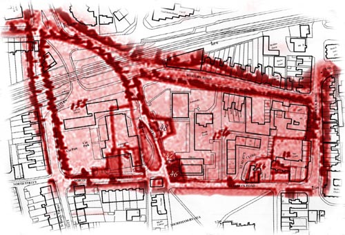
| Survey Number | Owner | Occupier | Description | Site Identification by Modern House Numbers or Area |
| 155 | Mary Connocks formerly Widow Bowyers later replaced by Elizabeth Burton | Empty
Empty Empty (malthouse) |
Malthouse Field formerly Knowles with two tenements, malthouse, yard, stable and garden adjoining | Bounded by Pond Road, North Street, John Street and from the Hebe Road junction with Southdown to Western Road |
| 154 | Mary Connocks formerly Widow Bowyers later replaced by Elizabeth Burton | ? | Alms House Field formerly Culver House Croft with a messuage and garden therein erected | Bounded by Pond Road, Western Road, Brunswick Road and St.Mary’s Road including St. Mary’s Cottage but excluding St. Mary’s House |
| 46 | New Shoreham Parish | ? | The Poor House | On the corner of Pond Road with St. Mary’s Road |
| 47 | Mary Connocks formerly Widow Bowyers later replaced by Elizabeth Burton | ? | Stable and yard late Dunstans | Approximately one quarter of the way up the western side of Pond Road |
| 48 | John Innott | ? | Vault, barn and premises called Redheads | Approximately halfway up the western side of Pond Road |
| 12 | Sarah Butcher
(Deane added later then replaced by John Rice) |
Sarah Butcher | Tenement and premises formerly Brigstocks, since Lins and late Athers | A square plot containing St.Mary’s House, No’s 1 – 3 St. Mary’s Road and northwards up to and including No 9 Brunswick Road |
Roger Bateman, Shoreham 2008
Sources:-
1782 Survey Map – West Sussex Libraries
1782 Survey Schedule – Arundel Castle Archives reproduced by kind permission of His Grace the Duke of Norfolk
Land Tax Returns – West Sussex Archives
Modern Street Map of Shoreham – Geographic Information System and Adur District Council, Licence Number 100018844