Aerodrome c1913

A collection from Alex Robertson. The early days of aviation at Shoreham.

Continue reading “Aerodrome c1913”

Mystery painting

Fisherfolk on a Tidal Estuary 1874, Shoreham by James Webb 1825 – 1895
Could this be the viewpoint?

Nelson writes:
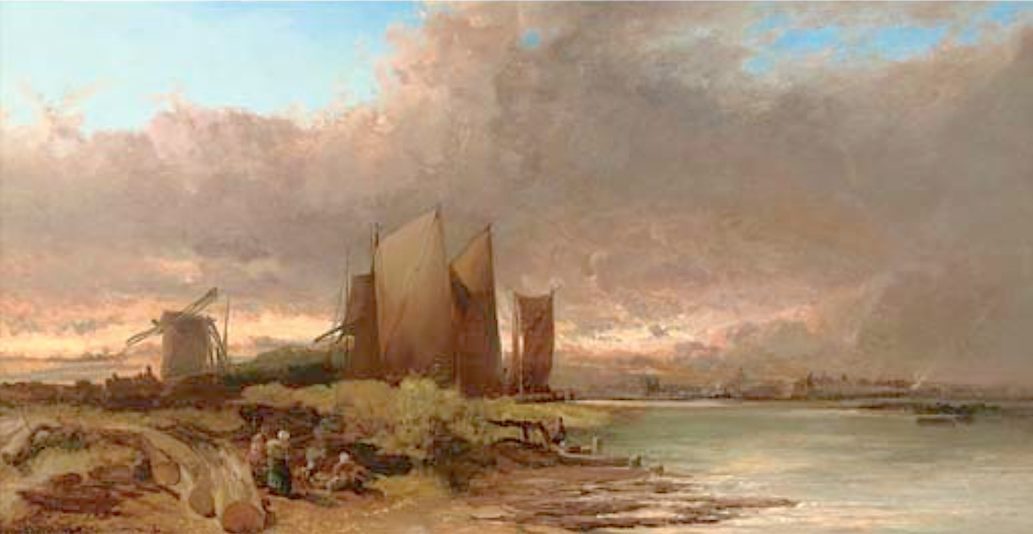
I’m sure we discussed this painting some years ago on the old web site without coming to any real conclusion as to its exact location. Assuming the content is not artistic licence then the view almost fits the history we have of one part of the Shoreham river front area. The windmill could be the one that stood on Mill Green at Ropetackle and behind it rising ground in the distance that may be Mill Hill; the town to the right and the timber work in the foreground is perhaps where the flood arch is now.

There are two question marks of this though.
The Norfolk Suspension Bridge had been well and truly built by the time the artist painted it and (if it is this area) should have featured as the centre piece of the painting so why has he masked the bridge with the boats’ sails?
The Ropetackle mill (we know it was a post mill and the painting confirms this) and the land it was on was sold in 1790 to Daniel Roberts who built a large granary on it. This had burned down by the 1820’s but could it be that the windmill was at a distance from the granary and still standing at the time of the painting – it certainly looks dilapidated with only two sails?

Thoughts and suggestions in comments below


Hebe

On the corner of Victoria Road and Hebe Road, the Hebe pub (possibly named after HMS Hebe) was built to serve the clientele of the very popular Swiss Gardens. The Swiss Gardens entrance (built 1838) was opposite. I estimate the Hebe was built after 1844 but before 1872.

The Hebe ghost image: 1894 and 2018 ©Roger Bateman
Continue reading “Hebe”

Star Inn

Ghost image ©Roger Bateman

Star Inn   In the 18th century the Star Inn on the corner of Church Street with the High Street was the once town’s main coaching inn and had stables stretching to East Street from the main building. The early 1900’s photo here was taken shortly after a face lift which, sadly, hides for ever its earlier heritage. 

Middle Street

A little known story is  about the demolition of the lovely old cottages in Middle Street that were replaced by today’s car park. Why just those in between other similar cottages in the street? It seems the whole row  were considered then to be unfit for human habitation and, true or not, one of the criteria was said to be a lack of natural light (which of course many old buildings do suffer from). During the inspection of those in Middle Street the  council official responsible for approving the demolishing had reached the cottages beyond today’s car park and, when asked if she needed the light on to be able to see, replied she could see perfectly well. In doing so she could not then condemn it and that, I am told, is why the rest survived.

1914 & 2020 image from NLS and Bing. https://maps.nls.uk/geo/explore/side-by-side/#zoom=19.7&lat=50.83261&lon=-0.27595&layers=168&right=BingSat

Shoreham Beach 1860s

I remember one midsummer morning (during the 1860’s) when we started at six o’clock (from Saddlescombe) to explore that remote wilderness called ‘No Man’s Land’ at Shoreham – then so lonely, now so populous (known) as Bungalow Town. We crossed the old suspension bridge, our country horses shrinking from the gleaming water on either side, turned on to the beach and rode to the only building there in those days*, the now ruined fort at the harbour mouth. From this issued a number of soldiers all in the scarlet coats of the period, who stared at us as if we had been a company of ghosts.
* Written by Maude Robinson in the 1930’s of her childhood 70 years previously who, with the passing of so much time, seems to have forgotten or missed seeing the Preventative Service Watch House, later the coastguard houses, that had been erected by 1829.