
Summary
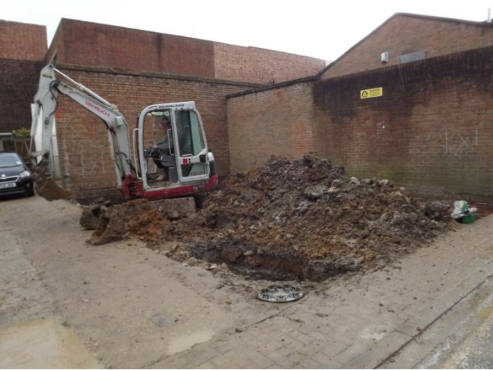
In August 2015 ASL were sub-contracted to maintain a Watching Brief on land opposite 3 Ship Street Shoreham, by West Sussex Archaeology LTD. This took place over the course of nine days in September 2015 on the 7th – 11th and then a second week on 21st, 22nd, 23rd and 25th.
Remnants of domestic medieval pits were partially excavated containing burnt cereal grains, building material and pottery dating to the 13th – 14th century. A later phase was represented by the demolished remains of an 18th century building and cobbled yard which was replaced by a later 19th century house. A mid 19th century French bayonet was found rammed through the yard surface. In the mid 20th century the house was demolished and the area levelled to create a car park space.
Contents
1.0 Introduction
2.0 Overall aims and specific objectives
3.0 Archaeological background
4.0 Methodology
5.0 Results
6.0 Finds
7.0 Discussion and interpretation
8.0 Archive
9.0 Acknowledgements
Figures
Fig.1 Location plan
Fig.2 Site plan showing location of trench
Fig.3 Site trench plan
Fig.4 Site plan after excavation
Fig.5 Long section south facing across site
Fig.6 West facing cross section through pit [19]
Fig.7 South facing cross section through wall [3]
Fig.8 Plan of lower feature; medieval pits [19] and [25]
Fig.9 Suggested plan for phase one; eighteenth century
Fig.10 Suggested plan for phase two; late nineteenth century
Fig.11 Phased plans for both periods superimposed
Fig.12 Ordnance Survey map regression showing outlines of Phase 1 (1874) and phase 2 (1899) footprints ©Crown copyright. All rights reserved. License number: ASL10003606
Plates
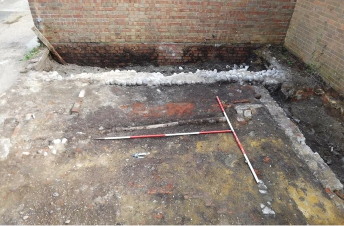
Plate 1 Looking SE at the site showing space constraints
Plate 2 The cobbled yard surface and associated drain. The wall on the right lies on top of the yard
Plate 3 Plate 3 demolition layer (2)
Plate 4 West facing section showing laid in-situ brick surface over demolition rubble (2) overlying cobbled yard [7] (scales 20cm)
Plate 5 wall [3] looking north (scales 1m and 2m)
Plate 6 Wall [3] foundations with medieval pit [25] underneath (scales 2m)
Plate 7 Wall [4] abutting wall [3] and well [6] to south
Plate 8 Features in the SE corner of the site after initial stripping (scales 50cm)
Plate 9 The well after partial excavation, note concrete capping in foreground (scales 1m and 50cm)
Plate 10 The cobbled yard and drain after cleaning (scales 2m)
Plate 11 The bayonet within the cobbles note twisted wire around the grip (scales 20cm)
Plate 12 Later wall [9] clearly laid over the cobbled yard (scales 20cm)
Plate 13 Foundation of wall [9] is clearly poured concrete (scales 20cm)
Plate 14 The ‘buttresses’ for a possible fireplace. Eastern buttresses removed (scales 20cm and 50cm)
Plate 15 The ‘ghost wall [10] east side
Plate 16 West facing section through pit [19] in baulk (scales 1m
Plate 17 Pit [25] seen cutting underneath wall [3]
Plate 18 The southern facing section through pit [25] underneath the cobbled yard and sub-floor levels
Plate 19. The corroded bayonet recovered from the cobbles compared to a pristine example (scales 20cm and 8cm)
Tables
Table 1. Spot dates for contexts
Table 2. Context register
Table 3.Pottery assemblage
Table 4. Later Post Medieval ceramics
Table 5. Ceramic Building Material fabrics
Table 6. Ceramic Building Material assemblage
Table 7. Mortar types
Table 8. Quantification of mortar
Table 9. Glass
Table 10. Geological Material
Table 11. The Shell
Table 12. The Metal
Table 13. Results from the sample residues
Table 14: Charred Plant Remains in the Sample
Table 15: Clay pipe assemblage
Table 16. Miscellaneous finds
Table 17. Archive content
Appendix
Appendix 1: Measurements of animal bones from SSS15 (Von den Driesch, 1976)
1.0 Introduction
1.1 This report is the result of an archaeological watching brief which was maintained during the excavation of ground works associated with development on land opposite Nos.1-3 Ship Street in the centre of the town of Shoreham-by-Sea, West Sussex (Fig.1 and 2). The site sits at 5.5m AOD and is centred at OS grid reference TQ 2143 0507.
1.2 This report has been produced for the owner, Mr Mike Deller by Lisa Fisher, Principal Archaeologist at Archaeology Services Lewes. The archaeological monitoring, as specified below, followed the recommendations made in a brief issued to the client by the Archaeology Team at West Sussex County Council in response to planning application number AWDM/0967/12.
1.3 The owner of the site has obtained planning permission for the erection of a two bedroom house and the archaeological watching brief recorded the excavation of the footings trenches and removal of the over burden (Fig. 3). This took place in accordance with a Written Scheme of Investigation prepared in July 2015 which was submitted to and approved by the WSCC Archaeology Team as well as Adur District Council1.
1.4 Due to other commitments, WSA were not able to undertake the fieldwork and so ASL were sub-contracted to undertake the work on behalf of WSA.
1.5 The Watching Brief was continuous and took place over the course of nine days in September 2015 on the 7th – 11th and then a second week on 21st, 22nd, 23rd and 25th.
1.6 Planning background: The following conditions were attached to the planning consent:
“No development shall take place until the applicant (or agent or successor in title) has secured the implementation of a programme of archaeological work in accordance with a written scheme of investigation which has been submitted by the applicant (or agent or successor in title) and approved in writing by the Local Planning Authority”.
1.7 This report has been prepared in order to meet the requirements of the planning condition in order to remove the condition as the final stage of mitigation.
1.8 The underlying geology of the site is the Newhaven Chalk formation overlain by Head deposits (clay, sands, silts and gravels) (http://mapapps.bgs.ac.uk/geologyofbritain/home.html). The development site itself lies at an approximate height of 5.5m above sea level.
2.0 Historical Background
2.1 The town of New Shoreham was probably founded in the late 11th century AD by William De
Braose as a port to rival Steyning. It grew in importance, reaching its peak in the late 13th century AD, when it was one of the principal ports on the south coast. However the succeeding centuries marked a sharp decline in its fortunes due to a change in trade patterns and the problems of silting in the Adur channel. This decline was to some degree reversed in the mid- 19th century with the advent of the railway and the expansion of the harbour2.
1 George Annaley, 2015. A Written Scheme of Investigation for a programme of Archaeological Works at the Car Park opposite 1-3 Ship Street, Shoreham-by-Sea, West Sussex. West Sussex Archaeology Ltd.
2 Harris, R., 2009, Shoreham: Historic Character Assessment Report. Sussex Extensive Urban Survey. West Sussex County Council
2.2 Ship Street lies towards the western side of the historic town of New Shoreham, and within what was probably a planned street grid dating from its foundation3. The earliest detailed historic mapping (see Fig.12) indicates that buildings extended at least half way up its length from the High Street, a spread encompassing the current development site; however earlier housing is likely to have extended for its full length.
2.3 The site now is surrounded by modern buildings, except to the north where, on the far side of a small car park, lies what was the Roman Catholic church of St. Peter, constructed in 1875, but converted into flats in 2002.
2.4 During the excavations many interested locals imparted information regarding the presence of former buildings on the plot. This included information that the building was once known as Trinidad Cottages and that part of Ship Street was known simply as ‘Trinidad’ 4. During the 18th century, the early maps (Fig.12) show this part of Ship Street contained a large property which extended towards where the Catholic Church now stands and was referred to as ‘a tenement, malthouse and stable’.
2.5 Given this background it was perceived that there was a high likelihood of encountering
medieval and later remains on the site. It was initially suggested that such remains may take the form of foundations or beam slots for buildings fronting onto Ship Street, with associated features such as boundary ditches, pits or post-holes also anticipated. To a certain extent this proved to be the case, although earlier medieval building foundations were not encountered but medieval pits were evident.
3.0 Overall objectives and Specific research aims
3.1 The National Planning Policy Framework (NPPF) states:
141. Local planning authorities should make information about the significance of the historic environment gathered as part of plan-making or development management publicly accessible. They should also require developers to record and advance understanding of the significance of any heritage assets to be lost (wholly or in part) in a manner proportionate to their importance and the impact, and to make this evidence (and any archive generated) publicly accessible. However, the ability to record evidence of our past should not be a factor in deciding whether such loss should be permitted.
3.2 In line with the principles of the National Planning Policy Framework (NPPF) the aims were to
investigate the assets of the site to seek a better understanding of the depth, extent, condition, nature, character, quality and date of any archaeological remains present.
3.3 To identify and record heritage remains on this site and to make the results of the investigation
publicly accessible through submission of a report to the West Sussex Historic Environment Record and the project archive to the local museum.
3.4 To establish a chronological framework for the site where possible, given sufficient dating
material.
3.5 Site specific objectives were:
To investigate the earlier foundations of former buildings on the site
To record any medieval features such as pits or ditches
3 Harris, R., 2009, Shoreham: Historic Character Assessment Report. Sussex Extensive Urban Survey. West Sussex County Council
4 Roger Bateman, local resident, pers.comm.
4.0 Methodology
4.1 The foundations for the proposed new dwelling consisted of five strip foundations supporting a concrete raft. The trench for the concrete raft covered the entire footprint of the site and extended to a minimum of 400mm below the current ground surface (see Fig.3). The strip foundations formed a hollow rectangle around the perimeter of the site, measuring c.5m x 8m in dimensions, each trench being 600mm wide with a minimum depth of 1.2m. A single central trench ran across the long axis of the rectangle in and east-west direction, just to the north of centre. This trench was slightly narrower at 450mm wide and a minimum of 1.2m deep.
4.2 The oversight for the raft foundation was excavated in two sections as the spoil from the first area stripped had to be piled on top of the second area to be stripped. During the first week on site, the over burden was reduced down to an in-situ cobbled yard and so this was cleaned back by hand and recorded prior to the second area strip. Luckily the extent of reduction came down to the top of the cobbled surface and was not extending beyond. Assistant County Archaeologist John Mills visited and it was decided to try and preserve the cobbles by laying a layer of sand topped by membrane.
4.3 The site was surrounded on the east and south boundaries by a tall brick wall which meant that
access was tight. To the west the site was immediately bounded by the pavement for Ship Street and to the north immediately bounded by an access route to the flats beyond. Due to party wall concerns the methodology was to excavate the footings trenches in alternate sections, so as to avoid any potential undermining of the upstanding walls. As a consequence the footings were excavated in nine different sections, with concreting occurring in between. This made for haphazard recording in such a tight space and there were considerable Health and Safety issues in wet conditions. Fig. 3 shows the numbering of the footings and order in which they were excavated.
4.4 Although the plan was for the trenches to be approximately 1.2m at times these exceeded
1.5m and so any features seen in section were recorded by sketch drawings and observed from the side of the trench only in order to maintain safe working conditions.
4.5 The excavation of both the trench for the raft and for the strip foundations was mechanically
excavated under archaeological supervision, using a toothless bucket, to the top of the archaeological deposits. Excavation of sensitive archaeological deposits were then undertaken by hand by staff of ASL.
4.6 The trench was tied in to the National Grid in conjunction with a site plan. A spot height of
4.63m AOD was measured in from the top of a manhole cover outside number 4 Ship Street which was used as the TBM. Levels were taken off this for relevant existing ground levels with all heights recorded on a levels register which will be kept in the archive.
5.0 Results
5.1 Spot dates
Table 1. Spot dates for contexts
| Context | Spot date | Artefact type |
| 1 | Mixed C16th – Mid 20th
century |
Pottery, metal, glass |
| 2 | Medieval (residual), late 18th – mid 20th from made up soil. | Burnt daub, pottery |
| 4 | Later C18th – 19th | CBM but some mortar definitely m/l C19th (later
repair?) |
| 4A | Later C19th – 19th | CBM |
| 5 top | Mid C18th -late C19th | Pottery |
| 5 lower | Early/mid C19th | Pottery |
| [6] well | Top (14)– mid 19th –mid 20th Base – late 18th – mid 20th | Pottery, glass, metal, (incl. corroded battery) |
| 8 | Mid C18th – early 19th | CBM |
| [9] wall | Mid 19th – early 20th | CBM |
| 9 under
wall |
Probably middle C18th | Pottery found under wall |
| 11 | Mid 19th – early 20th | Pottery and metal |
| 12 | Later C18th – 19th | |
| 13 | Early to mid 19th century | Pottery |
| 15 | Mid 19th – mid 20th century | Pottery, metal |
| 16 | Mid/Late 19th –early 20th | Glass, pottery |
| 17 | Mixed Later C13th – 14th & C17th/18th | Pottery |
| 18 | c. 1250-1350 | Pottery |
| 21 under wall [10]
east |
Later C18th – 19th | Pottery |
| 22 | c. 1800 – late 19th | Pottery, metal |
| 23 | c. 1780-1850 | Pottery and stone |
| 26 | c. 1250-1350 | Pottery and stone |
5.2 All archaeological deposits, features and finds were recorded according to accepted
professional standards, using context record sheets numbers 1-28. Deposit colours were recorded by visual inspection and not by reference to a Munsell Colour chart.
5.2.1
Table 2. Context register
| Context | Type | Description | Max thickness and /or height | Location | Deposit depth below
ground |
Max height
AOD |
| (1) | Deposit | Loose mid-brown to dark brown silt with high percentage of debris within. Modern made up soil with demolition material within and some older residual
artefacts. |
Only <150mm in the middle of the site with a deeper deposit
<220mm to the south. |
Across site |
| (2) | Deposit | Very firm with loose pockets within, dark brown silty soil with demolition rubble and pockets of orange and off-white soil. Approximately 30% CBM, and 30% lime mortar, 30%
silt and 10% gravel |
<260mm thick directly below (1) but over [6]. | A spread of firmer made up soil in the middle of the site within boundary foundation
walls |
||
| [3] | Masonry | A flint and mortar wall running for 5.30m in length in a north-south alignment one metre west of the eastern boundary, utilising natural water worn cobbles ranging between 70- 300mm in size. The facing sides face east and west and are bonded with lime mortar. It measures approximately 600mm in width and runs the length of the trench excepting an area of later truncation to the south where it meets
the modern wall. |
<280mm in height surviving above floor
surface but in total<1010mm in height surviving incl. foundation |
To the east side of the site ‘below’ (1) with a later wall [4] abutting it to the south west side and sitting on clay (24) as well as pit [25] | Top surface visible
before excavation |
|
| [4] | Masonry | Another wall running east- west approx.1.1m north of the site southern boundary, with flint cobbles <130mm in size but also built with brick fragments (not measureable as they are all different). This is also bonded with a lime mortar and measures 300mm wide and 3.5m in length across
the site. |
<750mm in depth from top of the surviving wall to base of foundation except in the cellar area where it is a minimum of
1.5m and beyond LOE |
South of site only, under (1) and sitting directly on top of natural clay (24). | ||
| (5) | Layer | A loose, dark brown very organic/humic garden soil to the east of wall [3]. This contains <30% rounded, water worn pea-grit
<200mm in size but this may be gravel from the former car park. |
<360mm thick | Under (1) and abutting wall [3] to the east of the cottage directly on top of pits [19] and [25]. | ||
| [6] | Masonry | A brick and mortar circular well made from unfrogged bricks measuring on average 170mm long x 110mm wide and 80mm deep. Bonded with lime mortar Excavated by hand
to depth of 402mm |
Approximately 600mm diameter this was partially truncated by modern footings to the
south. |
Under (1) and to the south of wall [4] | ||
| [7] | Deposit | A very firm cobbled yard surface constructed from water worn grey flints
ranging from 50mm-200mm in size. They did not appear to be bonded in-between the cobbles with mortar but were earth fast. |
One course in depth <20mm at a depth of
280mm on average, below ground |
Under (2) in the middle area of site
between wall foundations [3], [4] and [9]. Lying on thin bed of sandy lime mortar. |
| [8] | Masonry | Brick drain constructed from bricks laid on edge measuring 203mm long x 100mm wide and 70mm deep. Bonded with lime mortar running east-west forming a T-junction to the south and north in the west
side. |
Approximately 280mm below ground. Three sections; 1.2m east and 680mm to the west with
1.3m return to the south. |
On the north side within the cobbled yard [7] directly under (2) and running between walls [3] and [9] | ||
| [9] | Masonry | A flint, brick and mortar wall running in a north- south alignment 4m to the east of the western boundary between wall [4] to the south and wall [10] to the north. Utilising natural water worn cobbles
<140mm in size and brick fragments approximately 100mm x 55mm. The facing sides face east and west and are bonded with a yellow sandy lime mortar with <50% pea-gravel <30mm in size. |
It measures approximately 220mm in width and
approx.3.75m in length |
Under (1) and sitting on top of re- deposited clay (12). | ||
| [9]A | Masonry | A mortar and brick wall running in an east-west alignment between wall [9] and [27], 3m north of the
site southern boundary |
Approx.3.5m in length and 280mm wide | |||
| [9]B | Masonry | A small ‘buttress’ attached to the north side of wall [9]A, 1.5m east of the
western boundary |
400mm N-S x 200mm E-W | |||
| [9]C | Masonry | A small ‘buttress’ attached to the south side of wall [9]A, 1.5m east of the
western boundary |
300mm N-S x 200mm E-W | |||
| [10] | Masonry | A brick and mortar wall running in an east-west alignment between walls
[3] and [27]. Bonded with lime (60-70%) mortar with 30-40% rounded and angular pebbles <60- 103mm in size. |
Approx.6.70m in length and 300mm in width | To the north of the site, directly underneath (2) | ||
| [10]A | Masonry | A single course of brick on top of a mortar foundation running east-west for between walls [9] and [27] 4m north of the site
southern boundary. |
3.5m in length, 100mm wide and approx. 290mm deep | Under (2) above, (12) |
| (11) | Deposit | A very firm off white to mid-brown layer of demolition rubble. This contained <50% lime mortar and 30% rounded beach pebbles very similar
to (2) and probably one and the same. |
<150mm thick | Directly below (2) within a room to the north west side of the site and over re- deposited clay
(12). |
||
| (12) | Deposit | Compacted, yellow clay with grey pockets containing <1% angular flint and 2% rounded pebbles
<25mm in size. |
From top of wall [9] to base of sondage 420mm
(50mm thick) |
Below (11) within room to NW side and above earlier Victorian
deposits. |
||
| (13) | Deposit | A small area of very firm yellowish chalk (80%) with orange silty clay (10%) which had loose pockets within. The chalk was
<150mm in size and there was also <10% angular flint <150mm in size. |
800mm | In SE corner, adjacent to junction between walls [3] and [4] and next to well [6]. | ||
| (14) | Fill | Same as (2) | 240mm in thickness | Top fill of well [6], over (15)
below (2) |
||
| (15) | Fill | Second fill of well as
excavated, a very firm dark grey sandy silt with <5% angular flints <140mm in size, <5% rounded pebbles <15mm and <5% sub- angular chalk <20mm in size. A thin spread of concrete/mortar lies at the interface with (14) above. |
Not fully revealed but excavated down in section by 7 courses to depth of 450mm. Rest machined. | Below (14) within [6] | ||
| (16) | Deposit | Loose light brown – off white silty clay with <15% pea gravel <10mm and
<10% sub-angular brown river gravel <30mm with occasional chalk piece <60mm in size. Only seen in section as machine driver had excavated this NE corner to the east of wall [3] before arrival on site. |
<350mm thick | Directly below (5) | ||
| (17) | Fill | Top fill of medieval pit [19] a firm mid-orange clay silty clay with <2% sub-rounded water worn pebbles <60mm and less than 1% sub-
angular flint <20mm in size. |
<150mm thick | Under (16)
sub-soil to east of wall [3] |
||
| (18) | Fill | Second fill of pit [19] as recorded in section. A loose to firm mid-brown silty clay with less than 1% sub-
rounded water worn flints <50mm |
<200mm thick in the middle, lensing out to the south | Below (17) and within pit [19] |
| . | ||||||
| [19] | Cut | A pit feature partially recorded in section only measuring approximately 1m wide and up to 350mm in depth at base of trench. Break of slope gradual with sloping sides and gradual break of slope leading to a concave base. Filled with
(17) and (18). |
<350mm in depth | Cut below (16) in NE corner of site | ||
| (20) | Deposit | A firm, off-white re- deposited chalk with orange patches of clay within. The chalk comprises of <80% of the deposit and is a lens of screed laid down directly over clay to create a level area for a wall [10] running east-west across site. Recorded in sketched
section as footings dug. |
<250mm thick | Sitting underneath wall [10] and on top of (21) | ||
| (21) | Deposit | Base layer of wall [10] a firm , dark brown clayey silt (30% – 70%) with up to 30% water worn pebbles <80mm
in size within. |
<200mm thick. | Underneath (20) and above (22) | ||
| (22) | Deposit | A made up floor screed underneath the cobbled yard [7] consisting of a loose mid brown silty chalk with off white patches within and <30% worm sorted small chalk and gravel pieces <2mm in size and less than 1% rounded water worn pebbles <40mm
in size. |
<100mm thick | Underneath cobbled yard [7] and wall foundation [10]/(21) | ||
| (23) | Deposit | A firm orange brown clay sub-floor levelling layer below the cobbled yard with <5% rounded brown gravel <20mm. Contains residual Horsham Stone
tiles. |
<300mm thick | Directly below (22) and part of the top layer of sub- floor level (23A) below. | ||
| (23A) | Deposit | A loose dark brown silt
(<30%) with high levels of ash(<30%), chalk (<20%) <30mm in size and <20% pea grit chalk pieces. Lots of CBM within. |
<150mm thick | Directly below (23) and part of the same sub-floor level. Directly on top of natural clay
(24) |
||
| (24) | Layer | Very firm mid-orange clay with <10% angular brown
river flints <90mm in size. |
Natural so not measurable | |||
| [25] | Cut | A recta-linear cut pit
feature up to 1m in width roughly aligned NE-SW which was partially excavated at the base of the trench. Appeared to have vertical sides but the top is likely to have been truncated. The base was not reached. Filled with (26). |
Not fully
exposed |
Below wall [3]
on east side of site and cut through natural clay (24). Sealed with (23a) to west of wall. |
| (26) | Fill | Fill of pit [25], a loose mid- brown silt (80%) with rotted organic deposits and <10% chalk pieces <10mm in size and <5% angular brown flint
<50mm in size. |
<900mm minimum estimated depth. | |||
| [27] | Masonry | A flint and mortar wall running in a north-south alignment on the west side of the trench flush with the pavement so west face not revealed. Turns to meet wall [10] at North corner and buts wall [4] in the SW corner by the cellar. Bonded with lime mortar, same as
in[3] |
Not fully exposed so not measurable | |||
| [28] | Deposit | A second very firm cobbled yard surface constructed from water worn grey flints ranging from 50mm-200mm in size. They did not appear to be bonded in-between the cobbles with mortar. This area was smaller than the larger yard [7] | 1.5m N-S and
1.5m E-W. |
5.3 The Over burden
5.3.1 Context (1) was a very modern disturbed layer of debris which has built up since the area
ceased to be a parking space. Finds were relatively modern and only a small sample was taken to establish the date. This layer was cursorily recorded due to its modern date but did contain a wide range of artefacts dating from the 16th century (abraded pottery) to the modern day.
5.3.2 Context (2) was also a made up consolidated sub-floor level, probably laid down to create a
level area on top of a demolished building and also containing the demolition rubble itself. A corroded iron drain pipe ran through in a north-south direction (plate 3). There were patches of re-used brick laid in-situ (plate 4) and other areas contained patches of crushed CBM. The whole context was a patchwork of different building materials, including some areas which had higher soil content. In the south east corner of the site was found a fairly modern cat burial. The top end of a brass handled mid.19th century French (Chassepot) bayonet was found rammed through this layer in the middle of the site which extended into the context below (see section
6.8.2). Other finds included mid-late 19th century pottery.
5.4 The Eighteenth century building (Fig.9)
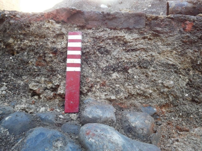
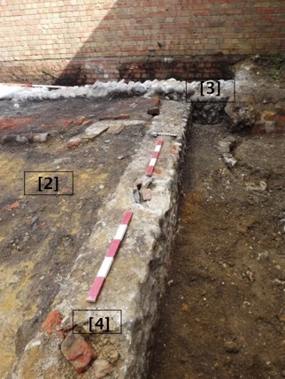
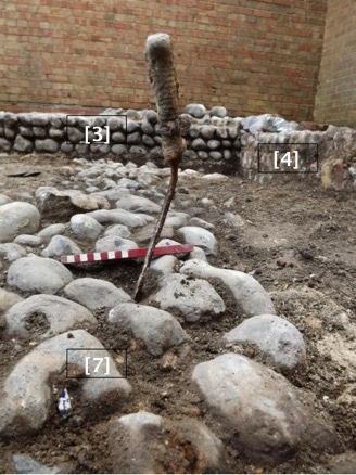
5.4.1 Context [3] was a substantial flint cobbled wall (plates 5 and 6) with off-white/cream sandy lime
mortar which matches a boundary wall which runs up the east side of Ship Street, although this is on a different alignment and does not match up. It is very similar in construction to wall [27] which is probably its counter-part on the extreme western side of the site. A test pit had been excavated through the west side of this prior to archaeological monitoring. It was not apparent at the time, but they had excavated through the side of a medieval pit, feature [25]. This was later recorded underneath the wall (plate 6).
5.4.2 A later wall [4] runs east-west and abuts wall [3] at right angles in the far south east corner
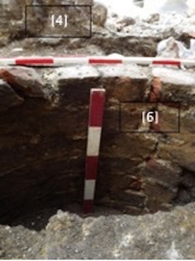
(plate 7) of the site. In turn, this wall continues west to form the foundation wall for a cellar located in the far south west corner of the site where it extended beyond 1.5m in depth at the extent of the trench but it was clear it extended deeper but was not measurable. The bricks used date between mid.17th – mid 19th and some of the mortar matches that in wall [3] but could be re-used materials. Finds retrieved from adjacent to it date to the later 18th – 19th centuries and some of the mortar in the wall represented a mid-late 19th century repair. A return wall here [27] continues in a north-south direction and would appear to be contemporary.
5.4.3 Wall [4a] was not fully recorded as it lie at depths of over 1.5m at the base of impact forming
one wall of a cellar. However, brief notes were made and a brick sample taken which dates to 18th – 19th century. Broken rubbish directly in this area dates to the Early 20th.
5.4.4 Wall [27] was not fully revealed; in part it lie underneath the edge of the pavement of Ship
Street to the west and in part, the north corner was truncated by later activity. It did appear to roughly line up with the E-W wall [10] but the phasing in this part was not clear. It was fairly evident that to the south side of the site, wall [4] butted up against this where the cellar room was evident.
5.4.5 Context (5) may be a former garden area to the East side of the site outside of wall [3] and
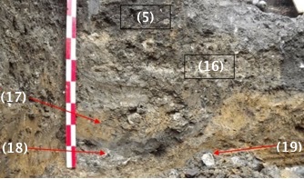
appeared to be the only highly organic garden soil on site. Early to late 19th century pottery was recovered from this soil. A second soil context (16) underneath the topsoil contained pottery Mid/late C19th. Three fragments of 18th – 19th century brick and roof tile also came from this deposit. It is likely that this garden area fell out of use after the building was demolished.
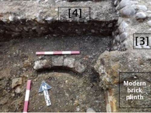
5.4.6 The well, Context [6], was partially excavated down to seven courses but was not fully recorded due to health and safety considerations, It was evident that the full extent of the well was not fully exposed through excavation and is likely to run much deeper and that the southern half had been truncated by later phases of building on site (plate 8). Some artefacts were briefly retrieved from the fill after the feature had been partially sectioned by machining. Artefacts from the lower deposits gave a mid 18th century date with the pottery from the higher deposits being early 19th century. The top fill of the well was the same as (2) in the middle of the site and was not given a separate context as it was the same material. Two mid-late 19th century artefacts (pottery vessel and a glass bottle) from the area above the well within (2) were found to be part of the same vessels retrieved from (2) to the north of the site. The brick sample from the well dates from the mid 18th – early 19th Century.
5.4.7 The fill of the well was only partially excavated for health and safety reasons (plate 9). The top
fill (14) was essentially the same as disturbed backfill layer (2) across site with a concrete cap to the well extending half way across the southern half of the well at a depth of 240mm below the existing top line of bricks. It is clear that the well was not complete and had been reduced in height. A second fill (15) lie underneath which was also similar to (2) but varied in colour and composition slightly. Machine excavation of the lower deposits produced artefacts dating to mid C18th – early 19th.
5.4.8 Context (13) was a small area of re-deposited and very mixed soil between wall [4] to the north
wall [3] to the east and the well [6] to the south. Excavation of a small sondage in this area revealed a drain hole punched through the wall foundation at a depth of 400mm from the top of the existing foundation. This measured 120mm in diameter and may have been associated with the well although no connection was visible.
5.5 Early nineteenth century
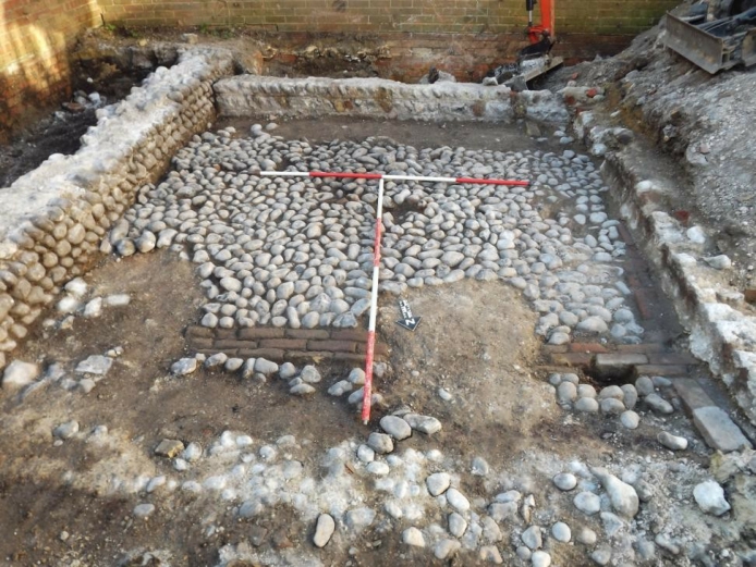
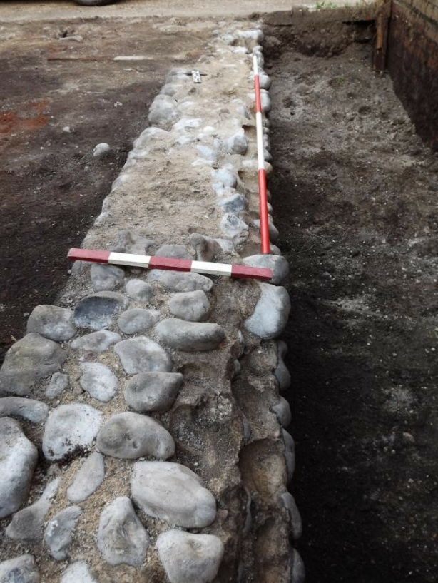
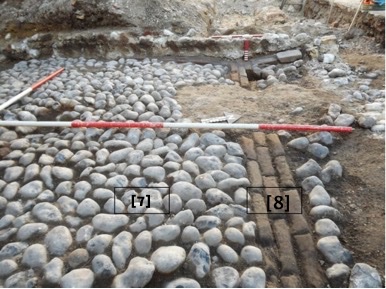
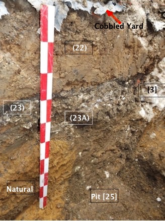
5.5.1 A flint cobbled yard [7] was sitting on top of a thin layer of mortar (plate 10) which in turn was
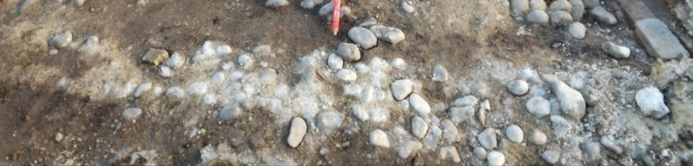
on top of a very disturbed and made up ground (22) which contained artefacts dating from 1800-1850. Below this was another disturbed layer (23) and (23a) both probably put down as a levelling layer prior to constructing the flint surface. Pottery from this combined layer dates from 1780-to 1850 so there is a mixed picture here regarding the construction date. Some patching within the yard surface was caused by the machine removing some of the cobbles and an area to the south was missing, where a later brick feature ran as a small foundation wall. This actually turned out to be part of the second phase of building on site but was overlooked due to its shallow depth. Consequently although this wall is on the 1899 map (Fig.12), it may have served a small outshot or porch. A French Chassepot bayonet dating to around 1875 was found rammed through this layer (plate 11) and was excavated to a depth of approximately 350mm.
5.5.2 A second area of cobbled yard [28] was exposed on the west side of the site. However, later
truncation has caused some confusion on this side but it is highly likely that this formed one surface with yard [7]. It was at the exact same level as the larger area of cobbles and appeared also to be overlain by a later wall. It is just possible that this whole area formed one large yard in the 18th century
5.5.3 The brick drain [8] associated with the cobbled yard (Plate 12) was recorded in four sections,
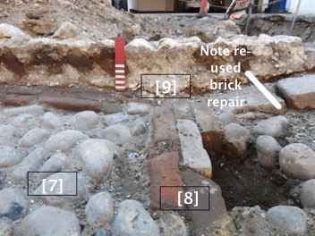
with the section on the west side being noticeably more worn than that on the east side. The bricks date to the mid C18th – early 19th. In the middle, the drain was missing; possibly marking the location of a former feature, approximately 700mm wide, but this was located in an area to the north of the site which had been disturbed in later years by the addition of a toilet and modern drain. This may have caused some disturbance to the earlier drain. Further later activity also truncated the far east side where it would have met wall [3]. The east-west alignment formed a T-junction which ran for 1.3m to the south and just 500mm to the north (later patching) where this part of the site was disturbed by the later activity on site. A later phase wall [9] was clearly built over the top of the drain.
5.6 Later nineteenth century (Fig.10)
5.6.1 Wall [9] was roughly constructed from fragments of brick with a foundation that would appear
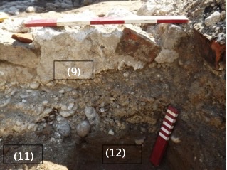
to be simply poured concrete (plate 13) with a high percentage of shingle pebbles cemented within. It is likely that this wall represents the latest phase on site, with some artefacts (probably middle 18th century in date) found directly underneath the foundation. It was evident that this wall had been built over the top of the cobbled yard surface [7] and the brick used to construct it was Mid C18th – early 20th. Pottery which lie adjacent to the wall underneath a floor in room 1 from context (12) dates to Later C18th – 19th.
5.6.2 Wall [9A] ran between wall [9] and potentially wall [27] although this again was uncertain on
the west side of the site. This seemed to form the most northerly wall of a second room within a later structure. This wall was mostly demolished prior to recording and was only apparent as a ghost of a wall at the base of impact for the raft foundation and so was not more fully recorded.
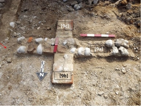
5.6.3 Two short ‘buttresses’ flanked wall [9A] and may have been later additions to help support an
unstable wall. The north spur [9b] was slightly longer than the southern counter-part [9c]. However, it is more likely that they formed part of a fireplace; although the matching eastern sides were missing during recording there was evidence in section for a removed foundation (marked ‘?’ on Fig.5) adjacent to these supports but previously removed. For certain the wall [9A] was very disturbed and almost non-existent at this point (plate 14).
in section below ground
5.6.4 Wall (10) was poorly constructed and fell apart when the machine bucket caught the edge of it
to the west. At the east side of the site it was very ephemeral (plate 15), showing as a thin spread of mortar but this was in the area of later disturbance where a modern toilet had been built. It is highly likely that the wall to the east side is earlier in date. To the west side it was very friable and was difficult to measure with just 290mm in height in-situ. It clearly butted up to wall [3] to the east side where the make-up of the wall was slightly different. The story on the west side of site was unclear where it met wall [27] as later disturbance meant that it was not clear if it butted onto or was bonded with it. For clarity this wall will therefore be referred to as [10] west or east. The contexts underneath this wall were recorded in section as the middle trench was excavated towards the east side. A mixed range of dates were retrieved which gives the underlying deposit (21) a date of Later C18th – 19th with the deposit under this (22) oddly later, between 1800-1850. There were also residual medieval roof tiles (C13th – 14th) within this context proving that a deal of disturbance whilst digging the foundations had clearly brought earlier artefacts to the surface.
5.6.5 Wall [10a] consists of a single course of stretcher laid bricks which were used as a joist support
in room one. This was not recorded further.
5.6.6 Context (11) was the backfill of room one within a structure which is likely to be the same
demolition rubble fill as (2).
5.6.7 A small sondage measuring 370mm x 670mm and 170mm in depth was hand excavated in the
SE corner of room one through (12) to ascertain if it was re-deposited clay or natural. This proved not to be in-situ, with a layer of flint pebbles and CBM dating to C18th – 19th lying at the base of the sondage. As this was below the level of impact for the raft foundation this was not further excavated. Further excavations for the footings trenches near this sondage proved that the area was heavily disturbed with a succession of Victorian pits below this re-deposited clay. These were not fully recovered for health and safety reasons after the trench side collapsed during a spell of wet weather.
5.7 Earlier medieval features (Fig.8)
5.7.1 There were two medieval pits: [19] and [25]. The first pit [19] was only seen in section (plate 16
and Fig.6) in the NE corner of the site where the machine driver had sadly machined the corner of the footings trench before attendance on site in the morning. This was recorded in section only and a few pieces of medieval pottery were retrieved from the top fill (17) Mixed Later C13th – 14th & C17th/18th pottery with C17th – 18th CBM and Later C13th – early 15th roof tile from top fill and the basal fill (18) contained pottery dating to c. 1250-1350.
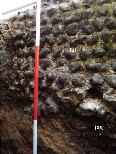
5.7.2 The second pit [25] was also partially recorded (plate 17 and Fig.8) as the top of this had been
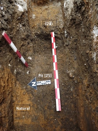
truncated by the building of wall [3] which sat directly on top of the pit, although it was partially sealed with a layer of made up soil (23) which extended across the cobbled yard area of the site. It would appear that the sub-floor area was platformed to create a level layer prior to building, which was when the top of the pit is likely to have been truncated. It formed a slight diagonal alignment underneath the wall (Plate 18) and there is a slight possibility that this pit extended to form part of the first pit [19] although it was not clear through excavations if this was the case. The fill (26) from the second pit contained pottery and roofing slate dating to c. 1250-1350 and was also sampled. This was found to contain fish bones as well as pottery and several charred plant remains including grains of oat (Avena sp.), hulled and twisted grains of barley (Hordeum vulgare L.) and rye (Secale cereale L.). Although excavations did not fully remove the fill (s) of the pit due to time constraints and safety reasons, the base of the excavated area was augered and continued down to at least another 400mm. This gives an estimated overall minimum depth of at least 900mm.
5.8 Other features
5.8.1 Other contexts noted include two small pits. One of these was cursorily recorded as a burnt
patch lying up against wall [3] to the north of the site on the west side where wall [10] abuts it and was found to contain matching pottery sherds to others found elsewhere on site within the demolition layer (2). Therefore this was considered as part of the demolition phase in the mid. 20th century.
5.8.2 The other pit lie at depths beyond 1.5m in the far SW corner of the site. As this was at the base
of impact within the cellar area a few artefacts were recovered swiftly by the contractor and the area dotted in. The artefacts also proved to be early to mid 20th century in date.
5.9 No other features were revealed. All trenches were dug to a maximum of 1.5m below current
ground levels although current ground levels varied across site. Consequently levels and measurements were also taken from the TBM level and have been retained in the archive. Monitoring was complete at this point as recording of all archaeological deposits and features was complete.
6.0 The Finds
6.1 The Medieval and Early Post Medieval Ceramics by Luke Barber
6.1.1 The archaeological monitoring recovered a small assemblage of pottery from the site, the
material coming from one of seven individually numbered contexts. The majority of sherds were recovered by hand, however, one environmental residue produced further pieces from the medieval pit [25]. The material has been fully listed in Table 3 as part of the visible archive.
Medieval fabrics have been allocated the West Sussex fabric code as cited in the Ropetackle excavations5 as well as a common name, while post-medieval ones have been allocated common name only.
Table 3: Pottery assemblage (High Medieval c. 1200/25-1350/75; LM – Late Medieval c. 1350/75- 1525/50; EPM – Early Post-Medieval c. 1525/50-1750; LPM – Late Post-Medieval c. 1750-1900+).
| Context | Fabric | Period | No | Weigh t | Comments |
| 1 | Tudor Green | LM | 1 | 16g | Green glazed jug |
| 1 | Glazed red earthenware (early) | EPM | 1 | 6g | Uncertain form. C17th – early 18th |
| 1 | Glazed red earthenware (late) | EPM/LP M | 1 | 30g | Dish with rounded club rim. C18th |
| 5 (base) | English stoneware | EPM/LP M | 2 | 162g | Handled bottle x1. 6. C18th |
| 18 | Medium grey sandy ware (Q/M9) | HM | 4 | 40g | Bowls (cooking) x2. Expanded rim. Reduced |
| 23 | Medium sandy ware (Q/M24) | HM | 1 | 4g | Cooking pot |
| 25 | Medium sandy ware (Q/M24) | HM | 1 | 8g | Cooking pot |
| 25 | Well fired sandy ware with rare chalk/shell (Q+s/M5) | HM | 6 | 142g | Cooking pots x2 (inc concave- topped expanded rim), bowl (cooking) x1 (expanded rim) |
5 Barber, L. 2011. ‘The Pottery’ in S, Stevens, Archaeological investigations of medieval and post-medieval
Ropetackle, Shoreham-by-Sea, West Sussex, Sussex Archaeological Collections 149, 72-121.
6 Green, C. 1999. John Dwight’s Fulham Pottery: Excavations 1971-79. English Heritage Archaeology Report No. 6.
| 25 | Fine/medium sandy ware (Q(f)/M3) | HM | 1 | 4g | Jug (oxidised) with beaded rim and external clear glaze |
| 25 | North French whiteware (UWW/M3) | HM | 1 | 2g | Green glazed jug |
| 25 <2> | Well fired sandy ware with rare chalk/shell (Q+s/M5) | HM | 8 | 20g | As above |
| 25 <2> | Sparse quartz temper (Q/M16) | HM | 1 | 2g | Cooking pot |
| 25 <2> | Fine/medium sandy SE off- white ware (Q/M19) | HM | 1 | 2g | Green glazed jug |
6.1.2 The High Medieval assemblage from the site is the earliest material present. The sherds are
notably fresh and have clearly not been subjected to any significant reworking. The fabrics and firing suggest the majority of pieces are best fitted within a mid/late 13th- to 14th- century date range. The Late Medieval and Early Post-medieval periods are represented by very low numbers of stray sherds – only in the Late Post-medieval period do quantities increase and begin to appear in contemporaneous contexts. Despite this none of the post-medieval sherds show extensive signs of abrasion.
6.1.3 The pottery assemblage is small with the majority consisting of residual and/or late types well
known of in Sussex as a whole. Although the medieval sherds are quite fresh and clearly in situ
they add nothing new to the study of Shoreham’s ceramics which was extensively covered by the assemblages from Marlipins Museum and Ropetackle7 8.As such the assemblage is not recommended for long-term curation and can be dispersed.
6.2 The Later Post Medieval Ceramics by Lisa Fisher
6.2.1 A total of eighty six sherds of later post medieval pottery were recovered from the site from
fourteen different contexts which have been condensed into table 4 as part of the visible archive.
Table 4. Later Post Medieval ceramics
| Contex
t |
Category | Sub-division | Quantity | Weight
(g) |
Date | Comments |
| Pottery | ||||||
| 1 | transfer print | 3 | 48 | L19th -mid
20th |
Two pieces of blue and white, one stamped ‘Stafford’ and ‘ War’ and is willow pattern, one is rim of flower motif cup and other is brown and
white plate rim very fresh |
|
| 2 | 7 | 60 | L18th – mid 20th | All blue and white refined earthenware some more worn and crazed than others, two willow pattern and one with bowl footring with castle design inside base and other with ‘per’ ‘meas’ on
outside |
7 Barber, L. 2006b (for 2005). ‘The Pottery’ in G. Thomas ‘Refining the biography of a marketplace tenement: A recent excavation and archaeological interpretative survey at ‘The Marlipins’, Shoreham-By-Sea, West Sussex’
Sussex Archaeological Collections 143, 192-195 (and ADS supplement).
8 Barber, L. 2011. ‘The Pottery’ in S, Stevens, Archaeological investigations of medieval and post-medieval
Ropetackle, Shoreham-by-Sea, West Sussex, Sussex Archaeological Collections 149, 72-121.
| 2 (pit) | 3 | 93 | Mid19th –
L19th |
Blue and white refined earthenware sherd from plate, very abraded from pit against wall [9] and two large dark cream rim sherds from chamber pot with two brown and cream transfer printed
strips around exterior |
||
| Above well (2) | 1 | 51 | E20th | Blue and white refined earthenware willow
pattern sherd from plate, slightly abraded |
||
| 15 | 3 | 79 | E20th | Brown and white plate base sherds from one plate with castle ruins depicted and base
marked …’on’ in decorative cartouche |
||
| (22) under cobbles | 3 | 54 | Mid 19th | Green and white refined earthenware rim sherd
from large serving bowl or wash bowl |
||
| 23 | 3 | 2 | LPM | Pearlware Cup x1 (landscape design) | ||
| Total | 23 | 387g | 26.5% | |||
| Porcelain | ||||||
| Surface find | 1 | 41 | Mid 20th | Lustre ware green tea pot lid with fluted finial | ||
| Surface find | 2 | 6 | E-Mid 20th | Pink painted lusterware, probably from cup | ||
| Total | 3 | 47g | 3% | |||
| 2 | Hand painted
wares |
4 | 8 | E-mid 20th | Refined earthenware with green stripe from one
vessel |
|
| Above well (2) | 1 | 96 | Mid 19th | Yellow slip trailed earthenware rim with dark brown glaze, probably from York potteries from
large rectangular dish |
||
| 5 (base) | Sunderland slipware | 1 | 40 | LPM | Dish with iron mottling | |
| Base of well [6] | 1 | 22 | Mid 19th | Refined earthenware with pink lustre stripe from base of large jug or vase, very stained and
crazed |
||
| (13)
base |
1 | 18 | E-Mid 19th | Brown slip decorated (sponged)iron glaze over yellow glazed rim from chamber pot. Matches
other piece found inside well |
||
| Total | 8 | 184g | 9% | |||
| Sussexware | ||||||
| 1 | 1 | 164 | E20th | One very thick ham pan or pancheon sherd crazed | ||
| 2 | 3 | 137 | E20th | Thick storage vessel fragments, one beaded rim,
all fresh |
||
| Above well (2) | 2 | 192 | Mid 19th | Thick storage vessel fragments, one rim, all fresh
but crazed |
||
| Under wall [9] | 4 | 237 | L19th-E20th | Thick storage vessel fragments, probably from one pot with interesting flower motif roulette
decoration under rim |
||
| (22) under cobbles | 1 | 20 | mid19th – L19th | Crazed base sherd from storage jar | ||
| Total | 11 | 750g | 12.5% | |||
| 2 | Creamware/
whiteware |
4 | 34 | L19th – mid
20th |
One cup base and body sherds in plain cream
refined earthenware, fairly fresh |
|
| 2 | 1 | 3 | LPM | Heavily burnt creamware | ||
| 22 | 1 | 34 | LPM | Yellow ware Bowl with beading along top of rim | ||
| 22 | 1 | 14 | LPM | Pearlware Jug/measure with industrially slipped annular lines | ||
| Surface find | 2 | 14 | Late19th -mid
20th |
Plain off white refined earthenware body sherds | ||
| Above well (2) | 1 | 14 | L19th – mid
20th |
Refined cream earthenware sherd | ||
| 2 (pit) | 4 | 219 | Mid19th –
L19th |
Refined cream earthenware plain sherds from
wash bowl, crazed |
||
| 15 | 1 | 18 | Mid 19th – L19th | Refined cream earthenware sherd base sherd from large jug or vase. Similar to those found in pit within (2) | ||
| 15 | 1 | 8 | Late19th -mid
20th |
Small sherd of refined earthenware with off
white crazed glaze. |
||
| (22) under cobbles | 3 | 42 | mid19th –
L19th |
Refined cream earthenware sherds from kitchen
bowl, one with cabled rim |
||
| Total | 19 | 400g | 22% | |||
| 2 | Salt-glazed stoneware | |||||
| Surface find | 1 | 18 | E20th | Fragment of stoneware bottle, ink or blacking
jar |
||
| 6 | 542 | E20th | Ginger beer bottle fragments, representing
three bottles, one is brown the others are cream |
|||
| 11 | 1 | 5 | Mid 19th – E20th | Small fragment of plain cream stoneware bowl base with footring | ||
| Total | 8 | 565g | 9.5% | |||
| Earthenware | ||||||
| 2 | 1 | 48 | Mid 20th | Fragment of flowerpot saucer, very fresh | ||
| 2 (pit) | 4 | 218 | E20th | Dark cream plain fragments from wash bowl,
very fresh |
||
| 2 (pit) | 1 | 15 | L19th – E20th | Yellow glazed sherd, probably from creaming bowl | ||
| 2 | 1 | 5 | E-Mid 20th | Rich iron glazed sherd of refined white
earthenware, fairly fresh |
||
| 2 | Buckley-type black-glazed redware | 1 | 20 | LPM | Uncertain form. All over glaze | |
| 23 | Glazed red earthenware (late) | 1 | 12 | LPM | Uncertain form | |
| Above well (2) | ||||||
| Base of well [6] | 1 | 287 | Mid 20th | Base fragment of flowerpot saucer, very fresh | ||
| 16 | 3 | 126 | L19th-E20th | Yellow glazed earthenware, one fits one from pit
within (2) |
||
| (22) under cobbles | 1 | 7 | Mid19th
L19th |
Yellow glazed earthenware probably from West
Country potteries |
||
| Total | 14 | 738g | 16.5% | |||
| Grand total | 86 | 3071g | ||||
6.2.2 These later ceramics were dominated by transfer printed refined earthenware (26%) dating
between the late 18th century and mid 20th century and creamwares (22%) of late 19th – mid 20th date mostly recovered from the demolition contexts. The demolition material on site in contexts (1) and (2) represented a background spread of ceramics dating between these main periods. The more sealed contexts below contained some slightly earlier ceramics including late 18th century -mid 19th century pottery under the cobbled yard (22) and (23). Individual dating elements have been combined with the earlier post medieval spot dates and incorporated into the main body of text so will not be discussed further here.
6.2.3 None of these ceramics were complete and hold no potential for further analysis and will be
discarded or returned to the owner.
6.3 The Ceramic Building Material by Luke Barber
6.3.1 A relatively large assemblage of brick and tile was recovered during the archaeological work.
The material was in mixed condition, with the earliest types being notably abraded and the later ones quite fresh. The assemblage is summarised in Tables 5 (fabrics) and 6 (quantification) as part of the visible archive.
Table 5: Ceramic Building Material fabrics
| Fabric | Description | Comments | Suggested date |
| B1a | Moderate/abundant fine ‘sugary’ quartz with some voids, common iron oxides to 6mm & occasional marl swirls | Pale orange fabric. Well formed, low/medium fired | Mid C17th – 18th |
| B2a | Moderate fine quartz with some voids, sparse clay pellets to 2mm | Dull yellow/pink fabric. Well formed, medium fired | Mid C18th – 19th |
| B2b | Sparse fine quartz, common red iron oxides/clay pellets to 12mm | Dull yellow fabric. Well formed & fired | Mid C18th – 19th |
| B3a | Sparse fine quartz, some voids, with moderate/abundant white calcareous inclusions to 3mm & occasional siltstone/sandstone grits to 2mm | Well formed & fired | C18th – 19th |
| B4a | Over fired aerated type tempered with slag and containing some voids | Crudely formed/distorted, hard fired | Mid C18th – 19th |
| B5a | Sparse fine quartz with many voids, moderate calcareous inclusions/flecks with sparse angular flint to 8mm | Crude formed, well fired. Frogged | Mid C19th – early 20th |
| B6a | Common/moderate calcareous flecks with occasional marl swirls | Well formed & fired. Even/well-mixed fabric | C18th – 19th |
| B7a | Moderate/abundant fine ‘sugary’ quartz with moderate/abundant iron oxides to 5mm & sparse pale marl flecking | Well formed, medium fired | C17th – 18th |
| T1a | Sparse fine quartz with rare/sparse marl swirls | Well formed & medium/well fired | C18th – 19th |
| T1b | Sparse fine quartz with sparse/common iron oxides to 1mm
& occasional marl |
Well formed & medium/well fired | C18th – 19th |
| T2a | Moderate/common fine quartz, rare/sparse iron oxides to 1mm & very occasional flint to 2mm | Well formed, medium fired (mathematical tile) | C18th |
| T3a | Moderate/abundant medium quartz | Quite well formed, medium fired | C13th – 14th |
| T4a | Sparse fine quartz, common/abundant marl streaks/swirls & common iron oxides to 1mm | Quite well formed, hard fired | C18th – 19th |
| T5a | Moderate/abundant fine/medium quartz, occasional iron oxides to 1mm | A buff fabric. Well formed, medium fired | Later C13th – early 15th |
Table 6: Ceramic Building Material assemblage
| Context | Form | No Fabric | Weight | Comments | |
| Modern pit | Peg tile | T1a 1 | 76g | 11mm thick | |
| 2 | Peg tile? | T1b 1 | 82g | 12mm thick (possibly pan tile) | |
| 2 | Mathematical tile | T2a 2 | 222g | 31mm+ thick tapering to 10mm at lower edge | |
| 4 | Brick | B1a 2 | 1462g | 65m thick. Sooted stretcher | |
| 4 | Brick | B2a 1 | 266g | 60mm thick. In M1a mortar | |
| 4a | Brick | B3a 1 | 1050g | 65mm thick. In M1a mortar | |
| 5 | Brick | B3a 2 | 80g | – | |
| 5 | Peg tile | T1b 1 | 38g | 12mm thick | |
| 6 | Brick | B4a 1 | 1228g | 65mm thick. In M4a mortar | |
| 8 | Brick | B2b 1 | 2342g | 220 x 100 x 65mm. Very worn stretcher – used on edge as kerbing or floor drain | |
| 9 | Brick | B5a 1 | 1426g | ? x 95 x 64mm. Crude splayed ‘U’ frog | |
| 9 | Brick | B2b 1 | 1178g | ? x 110 x 64mm | |
| 12 | Brick | B6a 1 | 76g | Worn face – flooring | |
| 17 | Brick | B7a 1 | 344g | 55mm thick | |
| 17 | Peg tile | T5a 1 | 24g | 12mm thick | |
| 22 | Peg tile | T1a 1 | 46g | 12mm thick | |
| 22 | Peg tile | T1b 1 | 52g | 12mm thick | |
| 22 | Peg tile | T3a 1 | 46g | 11mm thick. Worn | |
| 22 | Peg tile | T4a 2 | 60g | 9 & 12mm thick | |
| 23 | Peg tile | T1b 2 | 60g | 13mm thick |
6.3.2 The ceramic building material assemblage is notably varied in types and fabrics. Although a little
medieval material is present, the vast majority is of the Late Post-medieval period. The diversity of fabrics and finishes suggests either/or multiple phases of construction during the 18th to 19th centuries and/or the re-use of material within the period from this and surrounding sites. Such a suggestion is reinforced by the brick samples from walls [4] and [9] where each brick is of a different type.
6.3.3 The ceramic building material assemblage is essentially of Late Post-medieval date with a
scattering of residual earlier pieces. There are no particularly large or independently dated
groups. As such the material is not considered to hold any potential for analysis beyond that undertaken for this report and, following the extraction of fabric samples, has been discarded.
6.3.4 The Mortar
A relatively large number of mortar samples were recovered during the archaeological work. The assemblage is summarised in Tables 7 (types) and 8 (quantification) as part of the visible archive.
Table 7: Mortar types
| Type | Description | Comments | Suggested date |
| M1a | Off-white/cream sandy lime mortar with angular & sub-rounded flint to 5mm c. 50% & occasional pebbles to 25mm | Used for both flint and brick rubble walling | Undatable in isolation but post-medieval at current site |
| M1b | As M1a but with more flint (c. 60- 70%) | May simply be a variant due to uneven mixing | Undatable in isolation but post-medieval at current site |
| M2a | Pale yellow fine sandy lime mortar with 10% sub-rounded flint to 15mm (most to 5mm) | Finer version of M1a | Post-medieval |
| M3a | Hard mid/dark grey cement with 10% chalk (to 8mm), 10% coal (to 8mm) and occasional crushed tile (to 20mm) | Used as a late repair on current site | Mid/late C19th – 20th |
| M4a | Buff fine sandy mortar with 5% chalk grits to 1mm | – | Post-medieval |
| M5a | Buff fine sandy lime mortar with sparse crushed shell to 2mm & common black iron oxide grains | – | Post-medieval |
Table 8: Quantification of mortar
| Context | No Fabric | Weight | Comments | |
| 3 | M1a 6 | 288g | ||
| 4 | M1a 7 | 226g | ||
| 4 | M2a 5 | 110g | ||
| 4 | M3a 1 | 42g | ||
| 4a | M1a – | – | Adhering to brick | |
| 6 | M4a – | – | Adhering to brick | |
| 7 (under) | M5a 4 | 54g | ||
| 9 | M1b 2 | 168g |
| 10 | M1b 2 | 444g | ||
6.3.5 The mortar samples show a range of types in use at the site. M1a and M1b are typical gritty
lime mortars used for flint walling but the fact some examples were found adhering to bricks shows it was also used when rubble brickwork was being used (wall [4a]). The mixing of mortar types on the single wall (context [4]) confirms the observation from the bricks, that re-used material was present. Old mortar adhering to re-used bricks, the new mortar used to actually construct the wall and subsequent repair work (M3a) have given wall [4] a mixed suite of mortars.
6.3.6 The mortar samples from the site are not considered to hold any potential for further analysis
beyond that undertaken for the current report and have duly been discarded.
6.4 The Bone by Carol White
6.4.1 A small assemblage of 109 bones, weighing 331gm, recovered from five contexts. 98 of the
bones were recovered Context 2 which comprised a cat ‘burial’.
6.4.2 The remaining 11 bones were assigned to large mammal (2), medium mammal (5), sheep (2),
cattle (1) and bird (1).
6.4.3 Context 2, comprising a cat ‘burial’, considered by the excavation team to be modern. The
majority of skeletal elements were present with the exception of the carpals, tarsals and phalanges of the feet, with the exception of a single calcaneum to the rear right limb. The majority of the bones were in good condition, other than the scapula which were fragmented. All bones had fused indicative of an adult cat. No baculum (penis bone) was recovered; however it cannot be concluded by the absence of this bone that the animal was female. The pelvis was incomplete and again, the gender of the animal cannot be defined.
6.4.4 Context 9. A single thoracic vertebra fragment assigned to large mammal (probably cattle) was
recovered9. No fusion data was present and therefore an approximation of age at death is not possible.
6.4.5 Modern pit. A complete sheep metacarpal was identified. Proximal fusion of this skeletal occurs
prior to birth, with the distal fusion complete between 18-24 months10. From measurement and calculation the estimated height at withers of this animal was 59.42cm11.
9 Hillson, S. (2003) Mammal Bones and Teeth, An Introductory Guide to Methods of Identification. Institute of
Archaeology, University College London.
10 Silver, I. A. (1969) The Ageing of Domestic Animals in Brothwell, D and Higgs, E (Editors) Science In Archaeology. Bristol, Thames and Hudson.
11Von Den Dreisch, A. (1976) A Guide to the Measurements of Animal Bones from Archaeological Sites. Peabody Museum Bulletin 1. Harvard University.
6.4.6 Context 25. This context comprised the fill of a medieval pit. 8 bones were recovered, 5
assigned as medium mammal, 1 large mammal, 1 sheep and 1 bird. The sheep bone comprised a calcaneum of the left rear limb. Fusion of this skeletal element is complete between 30-36
months. From measurement and calculation the estimated height at withers of this animal was
50.11cm. A single tibio-tarsus of the Galliforme family – likely domestic fowl, was identified12.
6.4.7 Above the well (2). A single cattle astragalus was recovered. This bone exhibited evidence of
butchery with saw marks present.
6.4.8 Discussion
A small assemblage of bones recovered from a medieval pit with overlying later deposits. The estimation of withers height for sheep from the metacarpal recovered from a modern (18/19th Century) pit complies with measurements for post medieval animals and suggests breeding patterns introduced to produce larger animals. As mentioned above, the cat ‘burial’ was considered by the excavation team to be of modern date. A table of measurements is appended to this report.
6.5 The Later Post Medieval Glass by Luke Barber and Lisa Fisher
6.5.1 The glass recovered from the site consists mostly of later 19th century and modern glass
excepting one piece that was highly patinated. However, this fragment was from a handmade blown glass and likely to be 18th century in date.
Table 9. Glass
| Context | Type | Count | Weight | |||
| 2 | Clear | 3 | 147 | E20th | Thick fragments of two large bottles and one small piece of window glass
2mm thick. All slightly patinated. |
|
| 2 (pit) | 3 | 85 | L19th – E20th | Thick fragments of two large bottles probably mineral water bottles, one stamp ‘hton’ (Brighton?) and another base stamped ‘s sons’. All slightly patinated. | ||
| 2(pit) | 1 | 120 | E-mid
20th |
Small but complete press moulded bottle with yellow resin content and black resin filled ‘stopper’. This also contains a clear liquid, possibly from the washing process leached into the bottle. 122mm high, 50mm wide and
flattened rectangular in shape with rounded sides and short stubby neck |
||
| 16 | 1 | 37 | L19th –
E20th |
Thick base sherd of bottle, probably mineral water with ‘7 EVAN’ stamped on
base’ matches piece from pit within (2) |
||
| Brown | ||||||
| Above well (2) | 1 | 16 | Mid
20th |
Very fresh fragment from bottle | ||
| Green | ||||||
| (5) | 490g | C19th | large fresh pieces from the same green wine/beer bottle with a 75mm
diameter base with pointed kick and a well finished applied lip |
|||
| Base of well [6] | 1 | 7 | L18th-
mid19th |
Body sherd of handmade glass from bottle, not patinated | ||
| Total | 10 | 412g | ||||
6.5.2 None of the glass has potential for further study and has been discarded.
12 Cohen, A. & Serjeantson, D. (1996) A Manual for the Identification of Bird Bones from Archaeological Sites.
Archetype Publications
6.6 The Geological Material by Luke Barber
6.6.1 A reasonable-sized assemblage of stone was recovered from the site. The assemblage has been
fully listed in Table 10 as part of the visible archive.
Table 10: Geological Material
| Context | Stone type | No/weight | Comments |
| Surface find | Horsham stone | 3/2588g | Roof slabs. X1 200mm wide by 30mm thick with 12mm diameter peg hole. Top broken away on line of peg hole. Re-used – mortar stain on break |
| 2 | Welsh slate | 6/165 | Fresh Roofing slate probably from demolition of buildings |
| Base of well [6] | Welsh slate | 2/25 | Fresh Roofing slate probably from demolition of buildings |
| Test pit | West Country slate | 2/12 | Roofing slate. Silver grey type from contractors backfill found with burnt daub |
| Modern pit | Belgium-type slate | 1/46g | Roofing slate |
| 19 | Belgium-type slate | 1/10g | Roofing slate |
| 22 | Welsh slate | 1/18g | Roofing slate |
| 22 | Horsham stone | 1/194g | Roof slab. Grey/brown bedded. 12mm thick |
| 16 | Horsham stone | 1/100g | Roof slab. 18mm thick. Burnt pinkish |
| 23 | Horsham stone | 4/396g | Roof slab. Grey. 11mm thick. Re-used |
| 25 | West Country slate | 5/198g | Roofing slate. Pale silver green type |
| 25 | Horsham stone | 1/12g | Roof slab- |
| 25 <2> | West Country slate | 2/6g | Roofing slate. Pale silver green type |
| 25 <2> | West Country slate | 3/1g | Roofing slate. Silver grey type |
6.6.2 The entire assemblage of stone relates to different roofing materials through the ages though
much is clearly residual in its context. The earliest type consists of pieces of West Country slate, most probably relating to the 13th to 14th centuries. The presence of a piece of Horsham stone roofing slab in context [25] is interesting as the type does not normally become common until the later 14th to 15th centuries. As such the piece in this pit may be intrusive or be one of the earlier instances of its use for roofing in the medieval period. Once in use Horsham slab roofs continued for a long time (indeed it can still be found on some roofs in Sussex, including Marlipins Museum in Shoreham). The later slate includes typical Welsh slate as well as another type that is not typical for Welsh material, but closely matches samples of Belgium slate held by the author.
The stone assemblage is not considered to hold any potential for further analysis and has been discarded though slate samples have been retained for reference.
6.7 The Marine Shell by Lisa Fisher
6.7.1 A small quantity of marine shell was recovered during the excavation and these have been
outlined in Table 11 below. The species consisted of Oyster(Ostrea edulis L.), Native Clam (Tapes decussatus ) and Scallop (Pecten maximus ) and are all are edible sea molluscs common to the shores of Britain during the medieval period.
Table 11. The Shell
| Shell | Type | Count | Weight | ||
| 1 | Oyster | 3 | 243 | Large complete shells | |
| Surface find | 1 | 98 | Large complete | ||
| 2 | 6 | 376 | 4 compete | ||
| above well (2) | 1 | 86 | 1 complete large | ||
| Base of well [6] | 1 | 16 | Small but
complete |
||
| 16 | 1 | 105 | Large complete shell | ||
| (26) fill of med.pit | 1 | 26 | Small but
complete |
||
| (18) fill of med.pit | 3 | 36 | Fragmented | ||
| 2 | Scallop | 1 | 8 | Fragment | |
| 2 | Clam | 3 | 5 | Fragment | |
| 2 (modern
pit) |
1 | 5 | Complete | ||
| Total | 22 | 1004g | |||
6.8 The Metal by Lisa Fisher and Luke Barber
6.8.1 The majority of metalwork produced from the site consisted of early 20th century artefacts and
as such hold little potential for further analysis but have been included in table 12 as part of the visible archive. Drain [8] produced a 52g, 72mm iron long wedge of rectangular section and with squared head, mainly the result of having been repeatedly struck with a hammer. It may well have acted as a suspension hook on a wall. Context [19] produced a complete 77mm long (14g) headless nail, potentially of medieval date. The metalwork has no potential for further study and has been discarded.
6.8.2 The most significant artefact retrieved from the excavations was a French Bayonet found
stabbed through the cobbled yard surface [7]. Although mostly complete, this object (where manufactured from steel such as the blade) is much corroded although the brass handle remains fairly robust. A small piece of corroded twisted wire was found wrapped around the top of the grip, suggesting that something may have been secured to the top of the object. The steel blade was too corroded for any manufacturers marks to be seen which would help pin down the place of manufacture and date, but this type of bayonet is well documented and of the type known as a Yataghan sword bayonet, which was fitted onto a needle-fire rifle (M1866; 11 mm) referred to as the ‘Chassepot’, after its inventor, Antoine Alphonse Chassepot 13.
13 http://worldbayonets.com/Bayonet_Identification_Guide/France/france_2.html
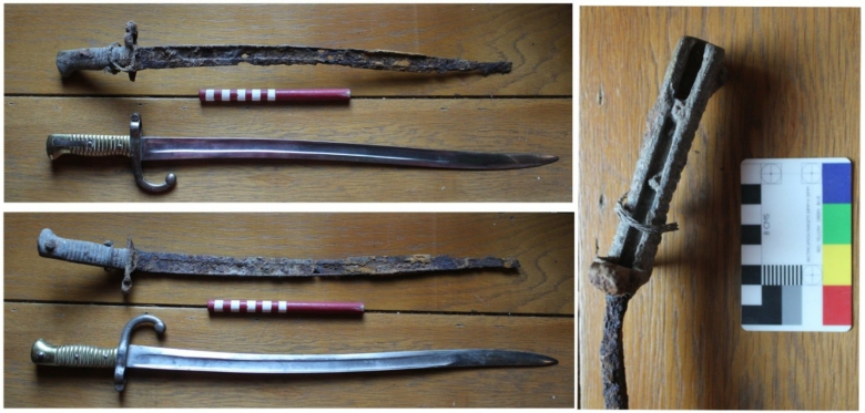
Unfortunately it cannot be seen if the blade was inscribed on the edge, as is the usual custom. The blade length would have been 578mm but the very tip of the blade has corroded and is no longer evident. The muzzle ring diameter is 17mm and is intact but the curved quillon or cross- guard was also much corroded and became detached from the blade, although this was found next to the bayonet, it was thickened significantly by rusted concretions so that its shape is no longer clearly evident. Although mainly of French manufacture, they were also manufactured in
England under contract and in service between 1867-1874, used widely by the French in the Franco-Prussian war of 1870-187114. No scabbard was found with the bayonet.
Marlipins Museum was approached with a view towards archiving the artefact but it was considered too corroded and so the object will be returned to the owner.
Table 12. The Metalwork assemblage
| Context | Type | Count | Weight | Date | ||
| 1 | Coppe
r alloy |
1 | 4 | Mid 20th? | Rivet with dark patina | |
| Above well (2) | 1 | 4 | Mid 20th? | Round lid of unkown form, 40mm diameter with machined line decoration
on edge, 10mm deep edge to side of lid |
||
| 15 | 1 | 6 | E-mid 20th | Plain rectangular buckle frame or fixing plate 25mm x 35mm | ||
| 2 | Iron | 5 | 251 | Mid 19th
– E20th |
Two cut nails 140mm long and one round shanked extruded round headed nail 155mm long. One amorphous bracket with wire extruding from the top could be part of bayonet attachment. One small bent nail corroded | |
14 http://Wikipedia.org/wiki/Chassepot accessed 30/11/16
| Above well (2) | 1 | 26 | Mid 19th
– E20th |
Cut nail, corroded and 105mm long | |||
| Base of well [6] | 1 | 53 | Mid 20th | Corroded battery, 48mm long and 27mm diameter with traces of orange and
blue paint with un-decipherable letters |
|||
| 8 | 1 | 52 | ? | Iron wedge | |||
| 11 | 1 | 47 | Mid 19th
– E20th |
Large rectangular cut nail, truncated shaft 21mm x 15mm flat head | |||
| 15 | 3 | 335 | Large fragments of forged highly corroded and amorphous iron forming right
angled shapes in section. |
||||
| (18) fill of pit
[19] |
2 | 36 | Medieval
? |
Highly corroded lumps of iron, possibly bolts or nails | |||
| (22)under
cobbles |
1 | 159 | Large corroded bolt 185mm long and 27mm square at the head. Forged iron. | ||||
| (26) med.pit | 1 | 64 | Probably
medieval |
Large corroded amorphous lump of iron unidentifiable shape | |||
| 2 | Lead | 4 | 272 | 20th
century |
Three lead strips 15mm wide and 145mm long, possibly from roof flashing
and one end of cut lead pipe 23mm diameter. |
||
| Total | 22 | 1257g | |||||
6.9 The Environmental Samples by Lisa Gray and Lisa Fisher
6.9.1 Introduction
The excavation work at Ship Street Shoreham produced two whole earth samples, one of which was contaminated and so was not processed. Only one 10L sample <2> has been assessed with the results presented below. The bulk samples came from the sealed fill (26) of a pit feature [25], provisionally dated to the high medieval period c.1300. The dry flot together with the macroplant remains recovered from the residue sample is assessed by the relevant specialist below.
6.9.2 Methodology
The single sample of 10L was processed in a flotation tank. The residues and flots were captured on a 1mm mesh to collect the residue and a 250μm mesh to collect the flot.
6.9.3 Results from the sample residues by Lisa Fisher
A magnet was passed over the residues during the processing stage. All the residues were dried prior to sorting. They were passed through 7mm, 4mm and 2mm geological sieves and each fraction sorted for both artefactual and environmental evidence (Table 13). All artefacts retrieved from the residues >2mm were picked out by eye, and the larger elements were sent off to the specialists for full analysis along with the hand picked pieces.
The majority of the magnetic material consists of slightly magnetic stones (80%) and other material such as burnt clay (5%). Of particular note is the presence of pieces of flat, scale-like hammerscale in the sample which amounts to approximately 10% of the magnetic material with small round globular forging residues amounting to another 5% of the material. The weight of these elements are relatively low, indicating a background ‘noise’ of smithing activity within the vicinity but this is unlikely to have been close to the pit. If a forge was nearby, the amount of hammerscale recovered would be substantially more that that recovered from the excavations. Without full excavation of the features it is impossible to do volume comparisons. No further analysis was undertaken on the material.
After extracting the magnetic material, the residues 1mm – 2mm in size were considered to have low potential for analysis. After discussions with the relevant specialists it was decided that these should be assessed by sampling a percentage of the remaining unprocessed contents. This was done by selecting a 10% sample from the processed sample. This was then subjected to assessment by means of a binocular microscope at x10 magnification. The results of the residues revealed some artefacts (modern mortar, burnt clay and small pieces of slate all probably worm sorted) but they were all considerably fragmented and do not hold any potential for further analysis. There were no complete molluscs and no complete profiles for the charcoal elements, such as thin twiggy stems. No seeds were present and less than 1% of small, abraded shell was present with the majority of the residue consisting of small stones (5%), quartz (65%), chalk (20%) and flint (1%). The results are logged below and no further analysis was carried out on these small fractions as they were better represented elsewhere with larger and more complete elements fully analysed by the relevant specialists. It is not recommended that any further work is done on the residues which are recommended for discard.
Table 13. Results from the sample residues
| Sample and
context (25) |
Residue size | Slate | Mortar | Fire cracked
flint |
Burnt clay | Magnetic
Residues |
| <2> from (25) | >2mm | X 45 pieces (green and grey) 7g and 2- 25mm long | X17 – 40g probably from wall above and intrusive | X19 – 43g between 4- 55mm in size | X 30 – 12g. Pieces are rounded and range from 2-
20mm in size |
See below |
| <2> from (25) | <2mm | Small abraded pieces, less than 1% of the total residue | Small abraded pieces of modern mortar, <5% of the total residue | – | Small abraded pieces, just over 1% of the total residue | 7g in weight from the whole sample residue |
6.9.4 The Charred Plant Remains by Lisa Gray
6.9.5 This sample was taken during an archaeological watching brief during the excavation of ground works associated with development on land opposite Nos.1-3 Ship Street in the centre of the town of Shoreham-by-Sea, West Sussex. This report will list the identifications of the plant macro-remains and supply any information they give with regards potential for dating and provision of economic and dietary information.
6.9.6 Recovery
The sample was processed in a Siraf type flotation tank with a 1mm mesh to collect the residue and a 250 μm mesh to collect the flot (L.Fisher, pers.comm). The residue was examined by Archaeology Services Lewes (L.Fisher, ibid). The pit was not fully excavated. The top of the pit is likely to have been contaminated by the construction of an 18thC wall and 19thC cobbled yard immediately above but the sample was taken from a well-sealed deposit (L.Fisher, ibid).
6.9.7 Identification and Recording
Identification of these plant remains were made using modern reference material (author’s own and the seed reference collection at the Institute of Archaeology, University College London) and reference manuals 15 16. Whole grains and embryo ends of grains were counted. Plant nomenclature for non-cereal plant remains comes from Stace 17, for cereals from Jacomet 18, and botanical terms from Cappers (Cappers ibid). The correct botanical terms are used in the tables and in the text, the term ‘seed’ replaces correct botanical terminology to avoid confusion.
15 Beijerinck, W. (1947) Zadenatlas der Nederlandsche Flora. Wageningen: Veenman and Zonen.
16 Cappers, R.T.J., Bekker, R.M. and Jans, J.E.A. (2006) Digitale Zadenatlas. Groningen: Barkuis Publishing and
Groningen University Library.
17 Stace, C., (2010) New flora of the British Isles- 3rd Edition Cambridge: Cambridge University Press
18 Jacomet, S. (2006) Identification of cereal remains from archaeological sites – second edition. Basel: Basel
University Archaeobotany Lab IPAS.
6.9.8 RESULTS
Table 14: Charred Plant Remains in the Sample.
| Sample | 2 |
| Context | 26 |
| Bulk Sample Volume (L) | 10 |
| Charred Plant Remains | |
| Avena sp. (grains) | 135 |
| Hordeum vulgare L. (straight hulled grains) | 13 |
| Hordeum vulgare L. (twisted hulled grains) | 2 |
| Secale cereale L. (grain) | 3 |
| Charred wood fragments >4mmØ | ++ |
| Charred wood fragments <4mmØ | +++++ |
Key to Estimated Quantities: + =1-10 items, ++ =11-50 items, +++ = 51-150, ++++ = 150-250., +++++ =
>250
This sample produced 15 counted charred plant remain per litre of samples soil. All of them were charred cereal grains. No chaff or weed seeds were present. Grains of oat (Avena sp.), hulled and twisted grains of barley (Hordeum vulgare L.) and rye (Secale cereale L.) were recovered. Absence of barley rachises meant that it was not possible to determine these grains were from two or six-rowed barley. The flot contained no faunal remains and no magnetic or other artefactual material.
6.9.9 Discussion
Plant remains were preserved by charring. Charring of plant macro-remains occurs when plant material is heated under reducing conditions where oxygen is largely excluded leaving a carbon skeleton resistant to decay 19.
The sample was taken from a sealed context but the 1mm fractions contained building material, pottery, animal bones and hammerscale suggesting smithing activity near the pit. This suggests that the charred plant remains entered the context as general background waste so will provide general rather than site specific information. The possibility of reworking and subsequent intrusively is also indicated by the presence of two modern dog’s mercury (Mercurialis perennis
L.) seeds.
The cereals present are typical for the Medieval and later periods in Central and Southern
England 20 21. Oats, and barley were common in the Medieval diet and consumed as bread,
potage or ale 22and might have been grown as a mixed ‘dredge’ crops. Rye was also a source of
grain for bread-making (Hammond ibid). With regards potential for radio-carbon dating this
sample does contain identified charred plant macrofossils but their provenance is dubious due to possibility of reworking.
19 Boardman, S. and Jones, G. (1990) Experiments on the Effect of Charring on Cereal Plant Components. in Journal of Archaeological Science 17, 1-11.
20 Pelling, R., Campbell, G., Carruthers, W., Hunter, K. and Marshall, P. (2015) ‘Exploring contamination (intrusion and residuality) in the archaeobotanical record: case studies from central and southern England’. In Vegetation History and Archaeobotany. (2015) 24: 85-99.
21 Van Der Veen M., Hill A., Livarda A. (2013) Medieval Archaeology, 57, 2013 The Archaeobotany of Medieval Britain (c ad 450–1500): Identifying Research Priorities for the 21st Century Medieval Archaeology 57,151-182.
22 Hammond, P.W. (1993) Food and Feast in Medieval England. Stroud: Sutton Publishing Ltd.
6.10 The Clay Tobacco Pipes by Luke Barber
6.10.1 The archaeological work recovered just 13 pieces of clay pipe from the site. The material has been fully listed in Table 15.
Table 15: Clay pipe assemblage
| Context | Element | Date | No | Weight (g) | Comments |
| 2 | stem | c. 1700-1750 | 1 | 2g | 26mm long. Slight wear |
| 2 | stem | c. 1750-1900 | 3 | 10g | 73mm, 48mm (embedded in mortar) and 52mm long. Latter stamped: BURNS CUTTY |
| 5 base | stem | c. 1750 | 3 | 8g | 30mm, 55mm and 72mm long. Quite fresh |
| 5 top | stem | c. 1750 | 2 | 6g | 57mm & 32mm long. Latter with start of Briar bowl decoration |
| 9 under wall | stem | c. 1750 | 1 | 2g | 45mm long. Probably C18th |
| 16 | stem | c. 1750 | 3 | 12g | 34mm, 86mm & 47mm long (latter with start of Briar bowl decoration |
6.10.2 The clay pipe assemblage consists of purely late post-medieval material all of which has no or only slight signs of abrasion. Although a little 18th- century material appears to be present the vast majority is probably of the 19th century. The material is not considered to hold any potential for further analysis beyond that undertaken for this report and has been discarded.
6.11 Miscellaneous Finds by Lisa Fisher
6.11.1 Just four pieces of material regarded as miscellaneous were retrieved which are difficult to date. However, it is likely that the burnt daub is from the medieval period. These were found unstratified within the backfill of test pit 2, which was excavated prior to archaeological monitoring. The fire cracked flint cannot be dated. None of these finds will be retained and have been discarded.
Table 16. Miscellaneous finds
| Context | Fire cracked
flint |
Burnt
daub |
Weight | |
| 16 | 1 | 13g | ||
| 18 | 1 | 98g | ||
| (25) fill of
med.pit |
3 | 37g | ||
| Test pit | 2 | 56g | Two pieces of burnt daub with impressions from withies found in backfill of contractors test pit against wall [3] |
7.0 Discussion and Interpretation
7.1 It should be noted that conditions on site were difficult; with very wet weather at times and the
spoil having to be piled directly above very deep trenches, some elements were recorded as safely and efficiently as possible. Consequently scaled drawings of sections, particularly in deep trenches beyond 1.2m, were kept to a minimum.
7.2 In addition, the methodology called for nine different footings trenches to be excavated and
immediately filled with concrete for safety reasons. This also prevented further drawings being made and hindered interpretation at times with constantly shifting levels and areas of re- deposited spoil confusing the uppermost layers.
7.3 Not all wall foundations were recorded in full as some of them were not fully impacted or
revealed in section. Those that were, may have been seen in section as the machine excavated and removed them, others may have only been recorded down the sides of the footings only. Cross sections for some of them were sketched rather than drawn to plan as the trench sides had become very unstable in some parts of the site and the trenches were deeper than 1.5m and so were not safe to enter as one had partially collapsed during a spell of wet weather. Consequently there is diversity in the way that the walls have been recorded; some were only ghost foundations whereas others were more robust.
7.4 The Medieval period
Two pit features were evident at the lower deposits on site dating to the High Medieval period. These lie at the extent of impact at approximately 1.2m. The first pit was only seen in section, due to the machine driver digging this corner of the site before an archaeologist was on site in the morning. The top fill of this pit (17) contained a mixed assemblage, with Later 13th – 14th century pottery as well as 17th/18th century artefacts. This is likely to indicate a high level of disturbance to this pit during the construction of wall [3] which was immediately adjacent to this feature. Consequently, these artefacts are highly likely to give a construction date for the wall, as potentially 17th century at the earliest. The lower and basal deposits contained very fresh and un-abraded medieval pottery dating between AD.1250-1350 and as such is likely to have been deposited in-situ as rubbish.
7.4.1 The second pit feature [25] was more fully excavated under controlled conditions although the
full extent of this was not revealed. The top had clearly been truncated by later development, including the construction of wall [3] which sat directly on top of the pit. The pit fills were sampled and contained pottery dating between AD.1250-1350, making this pit contemporary with the first pit [19]. Environmental samples produced burnt seeds indicating domestic activity using cereal grains such as oat, barley and rye. Animal bones such as sheep and domestic foul were also recovered from this pit and also relate to nearby domestic activity, as does the presence of smithing debris in the form of magnetic hammerscale retrieved from the sample residues. Finally, the recovery of several large slabs of Horsham Stone roofing material (C14th- 15th) may potentially indicate the demolished remains of a nearby later medieval building. However; caution should be urged as several other kinds of roofing material were recovered from both pits including slate (C13th-14th)and ceramic peg tiles (C13th-15th). The larger pieces of Horsham stone was found higher up profile and not in the pit and so is more likely perhaps have been disturbed by the ‘first’ phase of building recorded on site dating potentially to the 18th century. Alternatively they could have been sat in the top (now truncated) deposits of pit [25] and dragged up profile during construction or even utilized to form the sub-floor screed layer. Pit [25] formed a slight diagonal alignment underneath the wall and there is a slight possibility
that this pit extended to form part of the first pit [19] although it was not clear through excavations if this was the case.
7.5 The 18th century
7.5.1 It would appear that the natural clay geology was platformed to create a level layer prior to
building, which was when the top of the medieval pits are likely to have been truncated.
7.5.2 The phasing of the walls should have been fairly straight forward but due to the methodology
employed to ensure safe retention of the party walls which surrounded the site, it was necessary to excavate the area using different portions of trench opened at different times. This was problematical as no one area was open at the same time. This meant that phasing and recording became very difficult as levels and contexts were removed in a haphazard fashion across site. It is fair to say that wall [3] at the far east of the site was the first wall built on site and is likely to date from the mid or earlier 18th century. It would be reasonable to suggest that wall [27]on the far west of the site is of the same date as wall [3] due to similarities in construction and use of materials including the mortar and similar footings depths. A map regression from 1874 would also suggest that wall [4] and the ‘ghost’ foundation [10] to the east side only are also likely to date from this phase, including the cellar and wall [4a] in the south west corner which is built from bricks dating from the mid 18th century. However, artefacts found underneath wall [10] in contexts (21) and (22) to the east side dated from the late 18th to mid 19th century. In addition the layer below these (23) was dated by artefacts to 1780-1850. This does suggest that there was some activity in the late 18th century and it is more likely that the artefacts date from the earlier part of the suggested date range rather than the later part as this would make sense stratigraphically.
7.5.3 Of course it is entirely possible that the first phase of construction was simply wall [3], with walls [4]
and [10] and [27] built at a later date but with no firm dating evidence for wall [3] as such, it would be difficult to prove.
7.5.4 The well would also appear to be at least mid 18th century, as the bricks date this firmly to the first
phase of building on site, with later 18th century pottery recovered from the lower fill of the well. This means that access to the well was not possible for this building, unless there was a doorway in wall [4], or if wall [4] was built at a later date.
7.6 The Late 18th/ Early 19th century
7.6.1 What is not clear is whether the cobbled yard [7] was built at the same time as wall [3] as no
internal wall divisions are apparent in the early maps. The footprint for the building suggests that the yard comes into being during phase two but the dating evidence would suggest otherwise; the brick from the drain adjoining the yard is of mid 18th – early 19th century in date but could have been constructed utilising reclaimed bricks. Pottery found underneath a later wall [9] for phase two was probably middle C18th (could be residual) but it was clearly evident that this wall had been built over the cobbled yard, therefore making the phase two building later than the yard. This makes it more likely for the yard to be either later 18th century or perhaps early 19th century in date, which is backed up by pottery found under the yard dating between late 18th to mid 19th century. Two semi-circular ‘breaks’ in the yard to the north may be suggestive of some kind of gateway but with excavations down to the limit of impact this was not excavated further. Later disturbance in the north east corner from the creation of the outdoor privy also confuses the story. To add furthermore to the likelihood that the cobbled yard is from phase one, is the fact that the cobbles are laid up to the sides of wall [3] with the wall still slightly extent above the cobbles
(280mm at time of recording). If the cobbles had been added after the wall had been demolished it is far likelier that the ground level would have been raised to go over the demolished wall or that the wall would have been literally raised to the ground. However, there is no apparent access route into the yard during phase one, unless there was some kind of gateway not marked on the map. Early documentary sources point to the area being part of a tenement, malting and stable. It is just possible that one half of the phase one building was used as stables with the other side forming a small entrance yard with boundary walls around the perimeter.
7.7 The Late 19th century
7.7.1 The plan of the building does not appear to change until the end of the 19th century in 1899 when
the footprint for a different building is recorded.
7.7.2 The ‘garden soil’ (5) contained only mid-late 19th century pottery which was also evident in the
layer (16) below. It is likely therefore, that this area went out of use after the first phase of 18th century building was demolished in the late 19th century.
7.7.3 There are not many traces of the later 19th century walls left in-situ on site and this is partially due
to poor construction. This later footprint appears on the map regression exercise to fully utilize the whole area, which means that the most southern and eastern walls would have been totally destroyed by the building of the mid 20th century boundary walls which still flanks the site to the south and east. The wall to the north is probably one built over the top of former wall [10] to the west side of the site only due to a difference in materials and build on this side of the wall. The demolition of wall [10] east would allow for a new toilet block to be built and would also open up the area in the middle, thus creating an open access route to the yard area.
7.7.4 It looks likely that walls [3], [4] and [10] east from the phase one building were demolished during
this second phase, with wall [27] potentially re-used for the new footprint on the west side.
7.7.5 The only clear walls evident from this phase appears to be wall [9] which runs north south in the
middle of the site, [9a] which runs off this at right angles E-W and the ‘buttresses’ [9b] and [9c]which abuts this either side. This would have formed two small rooms, room 1 to the north where later 18th century CBM was found underneath the floor (12) and room 2 to the south.
The brick from wall [9] is of mid 19th century to early 20th century with some re-used C18th/C19th brick.
7.7.6 The ‘buttresses’ which appear either side of wall [9A] are likely to have formed part of a fire-place
although the eastern supports are missing. These were not evident during excavation until the middle footing trench was excavated across the site. The foundation was seen in section only and was not clear until the section was super-imposed on the site plan, thus placing this unknown masonry as the likely spot for the eastern supporting wall of the chimney breast. It is possible that when the building was demolished that the second support was removed entirely, thus only showing in section. The spurs [9b] and [9c] unfortunately do not show in the section drawing as these had already been excavated in the western footing trench prior to the middle footing being excavated.
7.7.7 Another later wall which appears to have cut through the cobbled yard to the south was very
shallow (approximately 320mm deep) and just 1.5m in length running east-west directly north of wall [4] to the east of wall [9] . Unfortunately this was not recognized at the time due to high levels of building material on site. This wall was only one course in depth which was laid directly onto a concrete base and assumed modern at the time. It would appear that this wall formed one of the
east-west walls for the phase two building although due to its shallow construction this may have been part of an out-shot rather than a two-storey supporting wall.
7.7.8 A disturbed layer (2) dating to the mid-late 19th century seals the top of the well and the
cobbled yard surfaces, representing either the demolition from the later building in the 20th century OR represents a covering of the cobbles to create a flat yard. The levelling layer contained some irregular patches of hard core and some in-situ but haphazard laid areas of brick. It is likely that this formed a later yard area to the last phase of building on site, with a free standing toilet block to the north which had truncated the cobbled yard surface below.
7.7.9 The top of a French bayonet was first discovered with the end of the pommel lying at the top of
context (2), which was the levelling layer on top of the cobbled yard surface. It is not clear if the made up ground (2) was piled around this artefact or whether it had been driven through this layer. Given that the date of manufacture is between 1866-1874 and that the phase two building is constructed somewhere between 1874 and 1899 based on OS maps, it is more likely that the bayonet was driven through the cobbled yard and left extant by some 250mm above the cobbled yard. A small piece of twisted wire was attached to the end loop fitting, as if it was used to secure something, perhaps to tie up an animal.
7.8 Twentieth century
7.8.1 The site appears to have been levelled in the mid –late 20th century and used as a car park. A
disturbed demolition layer (1) lay across the whole site which had clearly been used as a
dumping ground for some years. Once this layer had been excavated a second layer of disturbed soil became apparent but which contained early – mid 20th century artefacts mixed with some later 19th century pottery. At the top of this layer lie an iron drainpipe which probably came
from the demolished building. Other patches of in-situ bricks either post date the building or were formed in the early 20th century to cover over the cobbled yard.
7.8.2 It is considered that the aims and objectives of the watching brief were met with a high degree
of success.
8.0 Archive
Table 17. Archive contents
| Number of Contexts: | 28 |
| Number of Files/Paper Record: | 1 |
| Measured sketch plan and Section Sheets: | 4 |
| Photographs: | 144 Digital |
| Bulk Finds: | Three trays |
| Environmental Flots/Residue: | 1x 10L bag with 1 flot |
8.1 Marlipins Museum has been approached to take the finds but are not able to at present as the
museum stores are full. The paper archive will be held by ASL until such a time as the museum are able to archive this, an accession number will be obtained at this point and the file deposited in the museum. The owner has expressed an interest in retaining some of the material for the future inhabitants of the new building, including the bayonet. The remaining finds not retained by the owner have not been considered worthy of long term curation and will
be disposed of. A digital copy of the report will be retained in accordance with the WSI as follows:
the Historic Environment Record (a PdfA copy of the report plus a selection of images on CD)
the Local Planning Authority
the project archive temporarily held by ASL
the owner
the County Archaeologist
9.0 Acknowledgements
ASL would like to thank George Annaley for sub-contracting the work to us and also to the owner Mike Deller for his support and co-operation throughout. We would also like to thank Mark Taylor and John Mills, the County Archaeology team, for visiting and commenting on the work in progress and Herbie the machine driver without whom we could not have manoeuvred easily. Thanks are also due to the local residents for their interest and informative discussions about the site and to Pete Tolhurst for his help on site.
Lisa Jayne Fisher
Archaeology Services Lewes
February 2016
Appendix HER summary report
| Site Code. | SSS15 |
| Site
identification and address |
Land opposite 3 Ship Street, Shoreham, West Sussex. |
| County, district and / or borough | West Sussex, Adur District |
| O.S. grid ref. | TQ 2143 0507 |
| Geology. | Newhaven Chalk formation overlain by Head deposits (clay, sands, silts and gravels) |
| Project number. | ASL 69-15 |
| Fieldwork type. | Watching Brief |
| Site type. | Urban excavation for footings of three storey town house |
| Date of fieldwork. | Sept 7th-11th and 21st-23rd and 25th 2015 |
| Sponsor/client. | Mr.Mike Deller |
| Project manager. | George Annaley, West Sussex Archaeology Ltd. |
| Project supervisor. | Lisa Fisher, Archaeology Services Lewes |
| Period summary | High medieval , 13/14th century domestic rubbish pits, with later C18th and C19th structures. |
| Project summary. | In August 2015 ASL were sub-contracted to maintain a Watching Brief on land opposite 3 Ship Street Shoreham, by West Sussex Archaeology LTD. This took place over the course of nine days in September 2015 on the 7th – 11th and then a second week on 21st, 22nd, 23rd and 25th. Remnants of domestic medieval pits were partially excavated containing burnt cereal grains, building material and pottery dating to the 13th – 14th century. A later phase was represented by the demolished remains of an 18th century building and cobbled yard which was replaced by a later 19th century house. A mid 19th century French bayonet was found rammed through the yard surface. In the mid 20th century the house was demolished and the area levelled to create a car park space. |
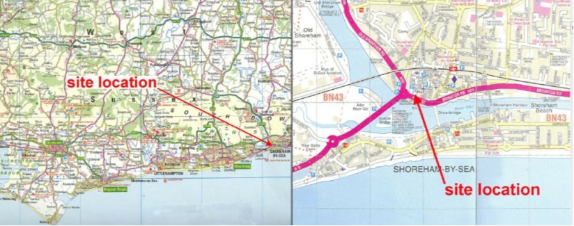
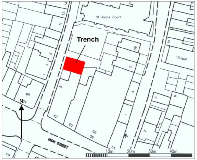
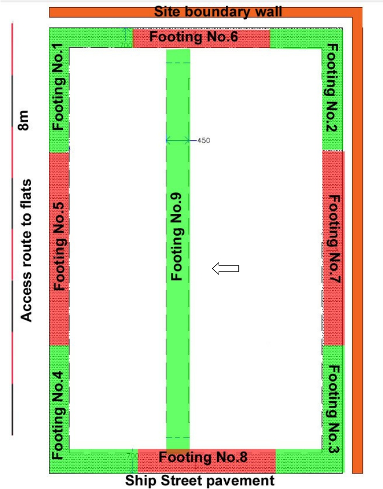
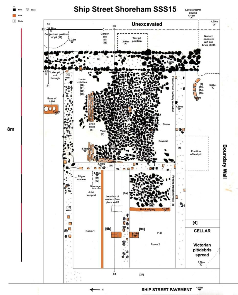
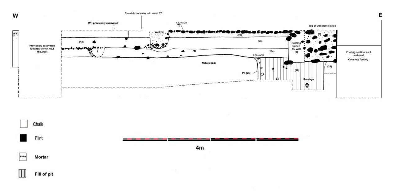
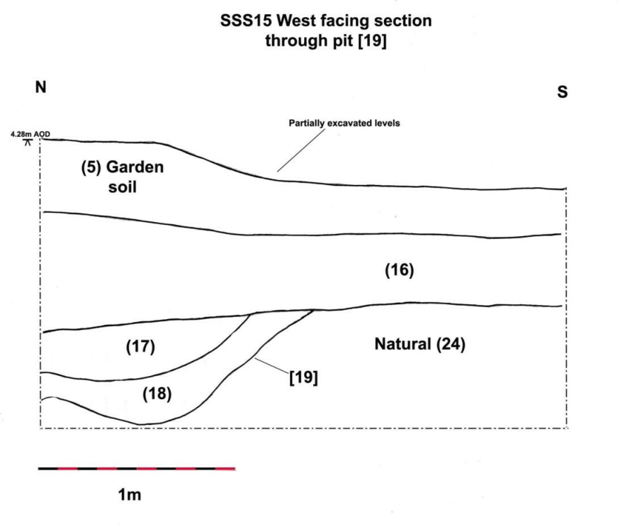
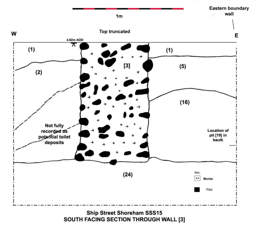
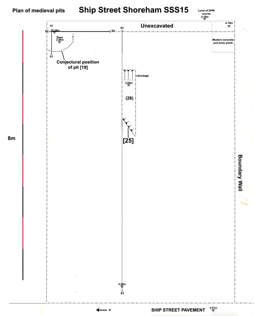
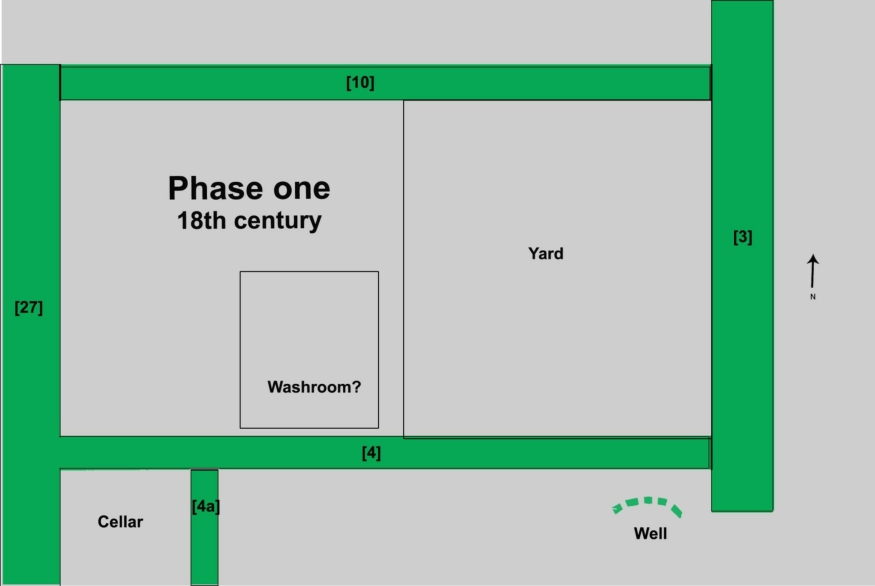
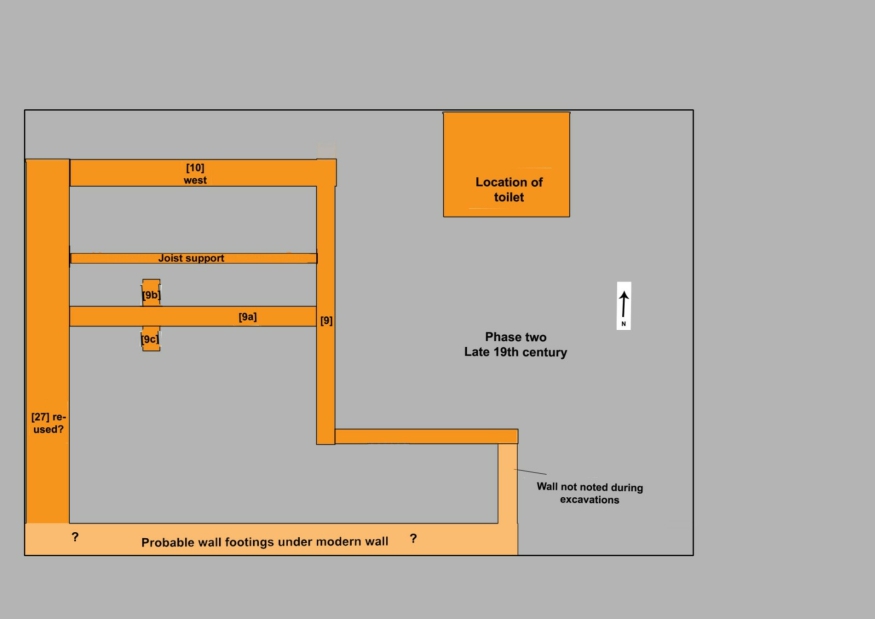
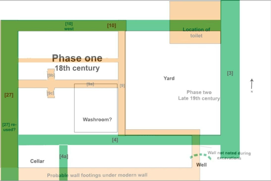
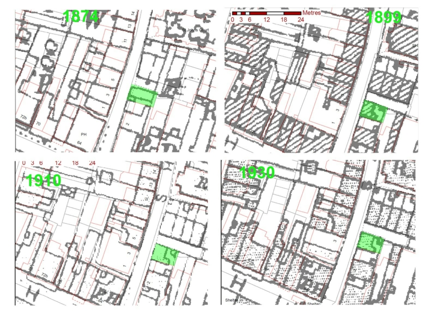
Appendix 1: Measurements of animal bones from SSS15 (Von den Driesch, 1976)
| CONTEXT | FEATURE | SPECIES | BONE | GL | Bd | Bp | Dc | Dm | GLm | GLC | SDO | DPA | GB | PL | GLP | SLC |
| – | Modern Pit | Sheep | MC | 121.52 | 25.38 | 22.79 | ||||||||||
| 25 | Fill of pit | Sheep | Calcaneum | 46.48 | 16.04 | |||||||||||
| 25 | Fill of pit | Bird | Tibiotarsus | 18.30 | ||||||||||||
| – | Above
Well? |
Cattle | Astragalus | 43.55 | 37.34 | 61.12 | ||||||||||
| 2 | Cat ‘burial’ | Cat | Humerus | 101.26 | 20.15 | 18.08 | ||||||||||
| 2 | Cat ‘burial’ | Cat | Humerus | 100.40 | 19.85 | 17.79 | ||||||||||
| 2 | Cat ‘burial’ | Cat | Femur | 108.10 | 19.72 | 22.24 | 10.27 | 108.24 | ||||||||
| 2 | Cat ‘burial’ | Cat | Femur | 107.91 | 19.39 | 22.46 | 10.41 | 108.01 | ||||||||
| 2 | Cat ‘burial’ | Cat | Tibia | 114.08 | 14.93 | 21.24 | ||||||||||
| 2 | Cat ‘burial’ | Cat | Tibia | 114.39 | 16.23 | 21.60 | ||||||||||
| 2 | Cat ‘burial’ | Cat | Ulna | 11.21 | 12.47 | |||||||||||
| 2 | Cat ‘burial’ | Cat | Radius | 96.34 | 13.86 | 8.89 | ||||||||||
| 2 | Cat ‘burial’ | Cat | Radius | 96.61 | 13.81 | 9.17 | ||||||||||
| 2 | Cat ‘burial’ | Cat | Calcaneum | 32.20 | 11.60 | |||||||||||
| 2 | Cat ‘burial’ | Cat | Scapula | 15.50 | 14.62 | |||||||||||
| 2 | Cat ‘burial’ | Cat | Scapula | 15.19 | 14.69 | |||||||||||
| 2 | Cat ‘burial’ | Cat | Sacrum | 29.76 | 28.73 | |||||||||||
| 2 | Cat ‘burial’ | Cat | Caudal Vert | 18.11 |
| CONTEXT | FEATURE | SPECIES | BONE | 1.00 | 3.00 | 5.00 | 9.00 | 7.00 | 8.00 | 10.00 |
| 2 | Cat ‘burial’ | Cat | Mandible | 61.74 | 55.77 | 19.34 | 12.34 | 6.98 | 28.34 | 11.86 |
| 2 | Cat ‘burial’ | Cat | Mandible | 19.26 | 12.22 | 7.33 | 28.31 | 12.16 |