
An Archaeological Reappraisal of the Loss of the Nave of the
Parish Church of St Mary de Haura, New Shoreham, Sussex
Giles Standing BA MPhil (Cantab)
This dissertation was originally submitted in partial fulfilment
of the requirements of the Degree of BA Archaeology
of the University of London in 2004
University College London
Institute of Archaeology
In this format © Giles Standing 2011
Abstract
This study is concerned with the archaeology and history of the ruined Norman nave (c. 1130) of the Parish Church of St Mary de Haura, New Shoreham, in West Sussex. It is intended as an up-to-date reappraisal of the lost fabric of the church, through the utilization of a geophysical and structural survey, and the analysis of primary documentary and pictorial sources. It is not, however, a history of the church’s complex architectural development, for which reference to other works should be made. It is hoped that this study will advance a greater understanding of the ruined nave, not least through the consideration of its future presentation to the public. The results of this investigation have led to the conclusion that St Mary’s nave fell into disrepair around the mid-17th century, and that it was demolished and restructured in the early 18th century. Improved provision for visitors to the site has also been addressed, with the introduction of information panels being recommended by current visitors in a public archaeology questionnaire conducted as part of this study.
List of Contents
Abstract ii
List of Contents iii
List of Illustrations iv
List of Tables iv
Preface v
Acknowledgments vi
Chapter 1 – Introduction and Aims 1
Chapter 2 – Review of Prior Research: 1853–1988 2
Chapter 3 – Project Methodology 6
Chapter 4 – Geophysical Survey 7
Chapter 5 – Standing-Building Survey 10
Chapter 6 – The Loss of the Nave: documentary evidence 17
Chapter 7 – The Loss of the Nave: probable cause 23
Chapter 8 – Public Archaeology Survey: a future for St Mary’s nave? 26
Chapter 9 – Conclusion and Future Research 34
Appendix 35
Bibliography 36
List of Illustrations
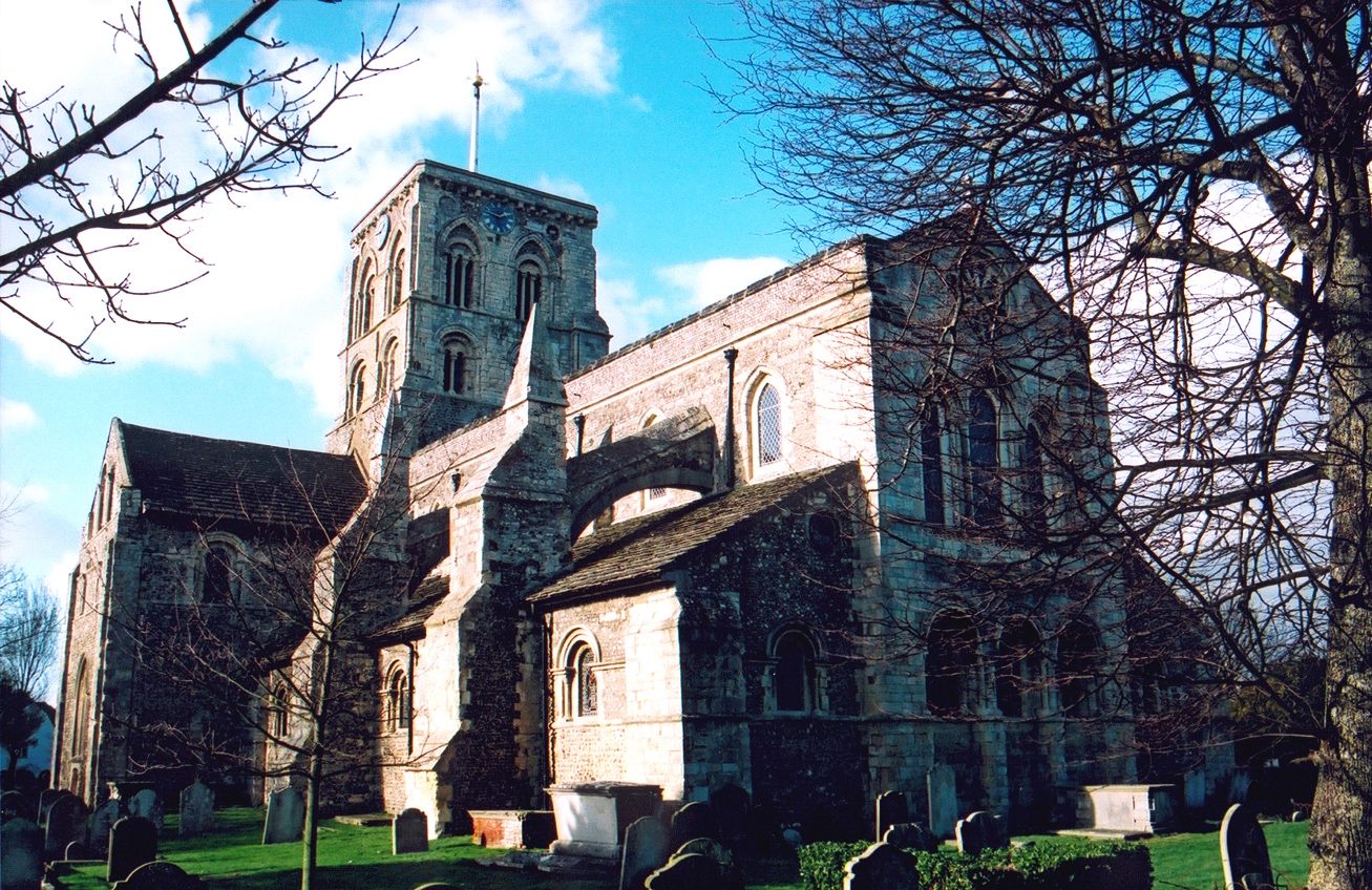
Title Page St Mary’s Church, New Shoreham, showing chancel
2.1 17th-century chimney-piece
2.2 17th-century chimney-piece (detail)
2.3 Excavation of St Mary’s south porch in 1915, showing east buttress
2.4 South porch east buttress during excavation in 1915
4.1 St Mary’s nave resistivity survey results (high resistance in black)
4.2 St Mary’s nave resistivity survey results (high resistance in red)
4.3 Detailed 10 x 10 m resistivity survey of north side of nave
4.4 Composite image of resistivity survey results and church plan
5.1 St Mary’s present west front, showing the late Rood window, etc.
5.2 Elevation of St Mary’s restructured west front
5.3 Stone-by-stone analysis of St Mary’s restructured west front
5.4 South-western nave pier arch replaced by bricks: front view
5.5 South-western nave pier arch replaced by bricks: side view
5.6 English-bond brickwork over the north-western nave pier
5.7 Flemish-bond brickwork (post-1630s) over the south-western nave pier
6.1 Lead plaque from re-leading the chancel roof in 1677
6.2 Plan of St Mary’s restructuring in c. 1714–15
8.1 The area of St Mary’s nave around 1907
8.2 Standing ruin of St Mary’s nave west end, behind trees and railings
8.3 Nave area today (left) and impression after gravelling (right)
List of Tables
1 Q2: Have you been to the church before today?
2 Q3: Did you know that half the church fell down several centuries ago?
3 Q4: Have you seen any of the remains in the churchyard?
4 Q5: Would it be a good idea to give the public more information..?
5 Q6: Which of the following ideas would help to reconnect the ruined nave..?
6 Q7: Are you..?
7 Q8: Are you..?
Preface
The illustrations throughout this study, numbering 20 figures and 7 tables, have been numbered according to the chapter with which they are primarily associated. The figures appear as two-digit references, the first number corresponding to that of the relevant chapter, the second referring to the number of the illustration with the chapter (e.g. FIG. 4.2 refers to the second illustration in Chapter 4). The tables refer to Chapter 8 alone, and are accordingly labelled in numerical order only. Illustrations are located at the end of each chapter.
Several quotes from 17th- and 18th-century documents are used, the original spellings of which have been preserved. Some more common words, however, have been substituted for their present-day equivalents by modern writers and editors, such as ‘the’ for ‘ye’, and this style has been followed in the present work.
Finally, some of the late-19th- and early-20th-century pamphlets which have been used contain limited bibliographic information, particularly relating to publication. At the time of writing, however, all such documents are available for consultation (reference only) in either Worthing Library or the West Sussex Records Office at Chichester.
Acknowledgements
I would like to extend my gratitude to the following for their advice or assistance in this project:
- Gustav Milne, Sue Hamilton, and Dafydd Griffiths of the Institute of Archaeology, UCL
- Martin Brown, Chichester Diocesan Archaeologist
- David Rudling, Neil Griffin, and David Martin of the UCL Field
Archaeology Unit
- Michael Norman, former Curator of Marlipins Museum, Shoreham
- Richard Andrews, Consultant Architect, St Mary de Haura
- Helen Poole and Gabor Thomas of the Sussex Archaeological Society
- Richard Channon, Clerk of the Worshipful Company of Shipwrights
- Stuart Rankin, Editor of the Redriffe Chronicle
- the staff of the West Sussex Records Office, East Sussex Records Office, The British Library, The British Museum, and Shoreham Library
- the Vicar and Churchwardens of St Mary de Haura
CHAPTER 1
Introduction and Aims
The Church of St Mary de Haura, New Shoreham (hereafter referred to as St Mary’s Church), is set apart from most other Norman churches in Sussex, and indeed England, on account of its extraordinary Transitional architectural style and design (Nairn and Pevsner 1965: 276–77). Yet, both the cause and date of the loss of this great church’s nave have eluded those who have studied the church, and written about its history, since the mid-19th century. The purpose of this reappraisal is not to overly reiterate the work of these previous commentators, but instead to bring the study of St Mary’s Church up-to-date through more recent techniques of archaeological interpretation and analysis.
Two main research questions underlie the present work, firstly relating to the loss of the nave and its ensuing demolition and blocking, and secondly to the future of the ruined nave as a site of public and community interest. A non-intrusive programme of fieldwork and historical research forms the core of this project on the recommendation of Mr Martin Brown, Chichester Diocesan Archaeologist, rather than intrusive excavation. Two distinct methods of analysis have been utilized in this field, that of a geophysical survey in the area of the nave and its surrounding churchyard, and a standing-building survey of the surviving fabric of the nave. These techniques have proved to be of considerable value in assessing both the original size and plan of the nave, and the nature and chronology of its ruination and restructuring.
In attempting to answer the second research question, concerning the possible future development and presentation of St Mary’s nave, a public archaeology survey of 50 visitors to St Mary’s Church and 50 parishioners was undertaken in order to broaden and contextualize an otherwise potentially isolated study. A discussion of further research which this project may hopefully promote concludes the study.
CHAPTER 2
Review of Prior Research: 1853–1988
The loss of St Mary’s nave has prompted debate since the mid-19th century, most notably from the time of Mr Edmund Sharpe’s seminal architectural study, read before the Archaeological Institute of Great Britain and Ireland in 1853 (Sharpe 1861). Local historians, too, have contributed in the Sussex Archaeological Collections (see below), the long-standing journal of the Sussex Archaeological Society, though these comparatively early articles are based on documentary evidence alone, much of which, in fact, does not relate directly to St Mary’s Church but to the history of the town and port of New Shoreham.
There are two main strands of thought relating to the loss of St Mary’s nave, being differentiated by the interpretation of a single piece of pictorial evidence. Following the publication of Sharpe’s work in 1861, one common cause was followed, relating to the decline of New Shoreham port and the town’s ensuing depopulation during the 15th century (Sharpe 1861: 46; Green 1877: 75; Adams 1891: 19; Salmon and Pilmore 1902: 28; Daniels 1907: 14, 18; Harrison 1920: 181; Glossop 1928: 3). This theory has sound theoretical grounds, in that the nave of St Mary’s Church was the financial responsibly of the parishioners, however few in number (Friar 2000: 87, 108; Child 1982: 15). Indeed, it would appear that nearby Hove Church was similarly neglected following the inundation of the sea from the late 16th century or before (Farrant 2001: 262).
This socio-economic model of decline was neglected, however, by five writers from 1903 (Salmon 1903: 237; Cheal 1921: 148, 186; Simpson 1971: 17, 19–20; Hudson 1980: 171; Woodcock 1988: 33–4, 89 n. 4). In that year, Mr Ernest Salmon published a short note on a carved wooden chimney-piece, which was at that time in the Fountain Inn in Shoreham High Street (now in Marlipins Museum, Shoreham). He was of the opinion that the right-hand panel of the chimney-piece portrayed an inexact but legitimate representation of St Mary’s Church with its nave intact (Salmon 1903: 237) [FIGS 2.1–2.2].
The significance assigned to this chimney-piece, and thus the depiction of the church, is its date, this being set by the depiction of the Arms of the Worshipful Company of Shipwrights in its central panel (Cheal 1921: 148). These Arms were originally granted in 1605 to the ‘Foreign Shipwrights’ at Redrith (Rotherhithe) in Surrey (now Greater London), south of the River Thames (Rankin 2000: 75, 77; Rankin 2003: 17–8). It has been suggested, therefore, that the chimney-piece depicts St Mary’s nave complete in or around 1605, and that it must have collapsed after this date (Cheal 1921: 148, 186; Simpson 1971: 17; Hudson 1980: 171; Woodcock 1988: 33–4, 89 n. 4). Accordingly, two theories of the nave’s destruction during the 17th century have been advanced: the war with France in 1628 and the English Civil War from 1643 (Nairn and Pevsner 1965: 276; Simpson 1971: 19–20).
A closer analysis of the iconography of the chimney-piece, however, calls the interpretation of Mr Salmon et al. into doubt. Firstly, the church depicted is shown without either transepts or aisles, which contradicts the form of St Mary’s nave when complete; if the aisles were depicted blocked (as they are seen today), then the columns and arches of the arcade would remain visible, rather than a blank outside wall. Secondly, the south porch is shown attached to the south wall of the nave rather than the south nave-aisle, again indicated by St Mary’s plan (see p. 3 below)
[FIG. 6.2]. Thirdly, the west end of the nave is shown without a west door (attested by the surviving beam slot in the remaining west wall), and with a large Decorated window, in which style no other features survive at St Mary’s. Furthermore, fourthly, there is no evidence that St Mary’s had a spire (Woodcock 1988: 39–40 n. 12). Reference to the church’s ‘Steeple’ in 1686 is by no means conclusive, for the term was similarly applied to St Nicolas’s Church (Old Shoreham) in the same source (Ford 1994: 35), though around that time St Nicolas’s does not appear to have carried anything more than its present peaked tower (as illustrated in 1645 by Wenceslaus Hollar; he did not record St Mary’s, Pennington 1982: 154). These and other more general features, such as the incorrect rendering of the nave and tower windows, and the obviously unsupportable central tower (shown perched precariously above the nave roof), suggest that the church depicted was not based on any real, standing example, but rather is a stylized, schematic representation of a church in the early 17th century. It can be stated with some confidence, therefore, that the chimney-piece does not offer a terminus post quem of 1605 for the loss of St Mary’s nave.
The present study, then, has effectively broken the historical mould, following only three other writers since 1903 (Daniels 1907: 14, 18; Harrison 1920: 181; Glossop 1928: 3) in rejecting the long-held view that the chimney-piece shows the nave intact around 1605. The accounts of the nave’s history published between 1861 and 1988, therefore, reveal no concrete evidence for the dating of the loss of the nave, nor, accordingly, any definitive reason for its occurrence.
This interpretation is unfortunately applicable also to the only archaeological fieldwork carried out on St Mary’s nave prior to the present study, that of its partial excavation in 1915. In that year, the Revd Walter Marshall (then vicar of St Patrick’s Church, Hove) directed an excavation in the area of the ruined nave, predominately at its western end and along its south side, at which time the discovery of a sizeable porch abutting the south nave-aisle was made (Marshall 1915: 8, 14, 33; Norman 1955; Simpson 1971: 39) [FIGS 2.3–2.4]. The porch’s floor level appears to have been buried to a depth of around 2 feet (c. 60 cm), attested by a number of 5-square-inch, red medieval floor tiles discovered in situ (Marshall 1915: 8; Norman 1955). Several unglazed red tiles of a similar size are preserved at a comparable depth inside the church at the base of the tower steps, perhaps dating to the time of the porch’s construction, around 1400 (Simpson 1971: 39). At this time, a smaller building was erected to the west of the porch, fragments of its slate roof being preserved in the west wall of the south transept (Holden 1965: 73, 76; Holden 1989: 80, 83)
[FIG. 5.1]. This may have served as a sacristy, or perhaps a chapel (Simpson 1971: 41; Ratcliff 1972: 14).
As was common practice at the time of the 1915 excavation, the tracing of the plan of St Mary’s lost nave appears to have been the central objective of Revd Marshall’s excavation (e.g. Clarke 1986: 68), thus, regrettably, no stratigraphic or other archaeological information was recorded. A major role of the present study, then, is to attempt to rectify this unfortunate deficit through archaeological means other than re-excavation, a discussion of which follows.
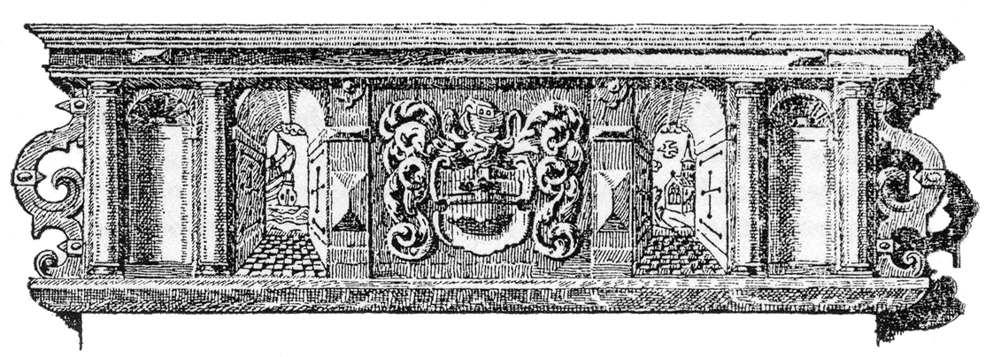
FIG. 2.1 17th-century chimney-piece
(Image: Cheal 1921: 148)
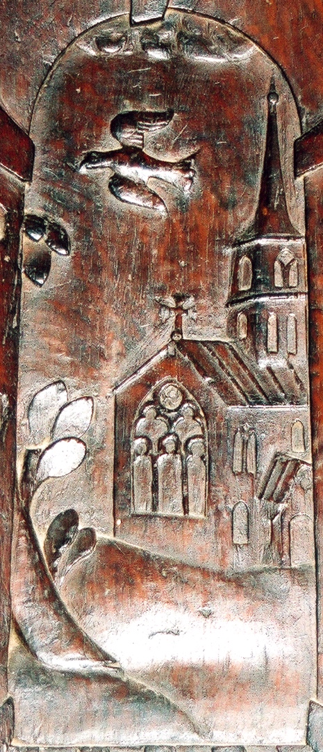
FIG. 2.2 17th-century chimney-piece (detail)
(Photo: author)
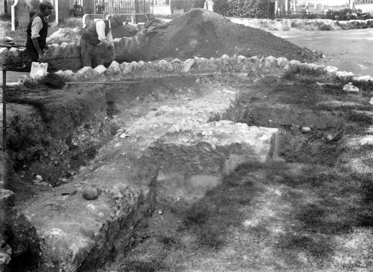
FIG. 2.3 Excavation of St Mary’s south porch in 1915, showing east buttress
(Photo ©: by permission of Michael Norman)
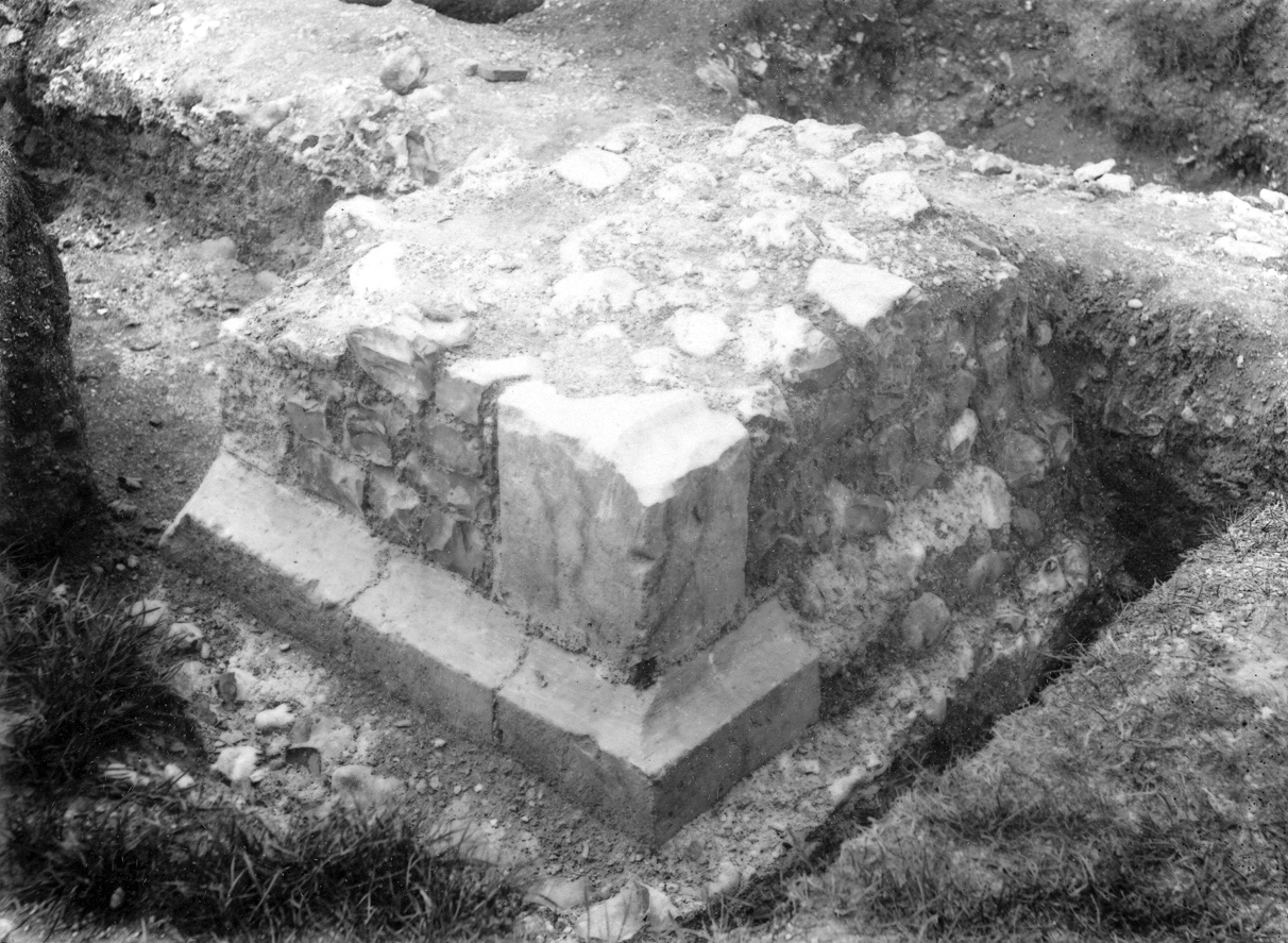
FIG. 2.4 South porch east buttress during excavation in 1915
(Photo ©: by permission of Michael Norman)
CHAPTER 3
Project Methodology
The methodology underlying the present study of St Mary’s nave is based specifically on non-intrusive fieldwork, encompassing three main investigative approaches: a resistivity survey, a standing-building survey, and a public archaeology questionnaire.
St Mary’s spacious churchyard is a complex and diverse archaeological environment. As well as changes to the church’s fabric since its construction in the early 12th century (Nairn and Pevsner 1965: 276–77), the churchyard has also been considerably disturbed through innumerable inhumations since that time (Rice 1941: 113–15; Cheal 1921: 189–91). For this reason, it was advised that excavation should not be undertaken in or near the nave (see p. 1 above), as both its interior and exterior have been used to accommodate burials from at least the 18th century (manifested by the surviving graves stones in and around the nave) [FIG. 8.1]. As the analysis of buried human remains did not form part of this study (e.g. Rodwell 1989: 157–80), their unnecessary disturbance was deemed avoidable by investigatory means other than excavation. In order to confirm the plan of the nave established in the 1915 excavations, a resistivity survey was instead undertaken in August 2003 in the area of the nave (see Appendix), the results of which are discussed below (see Chapter 4).
Having established its plan, an analysis of the standing structure of the nave was undertaken through the methodical study of its remaining fabric. The main focus of this standing-building survey was the single surviving nave bay, adjacent to the tower. In order to better understand the complex arrangement of this structure, a stone-by-stone illustration was made of this easternmost bay, now the present west front. As the use of scaffolding was not feasible, an enlarged 35 mm photograph of the west front [FIG. 5.2] was instead traced onto transparent acetate paper, and then digitized using photographic imaging software. The leaning perspective of the image (resulting from the wide-angle photograph) was digitally corrected, and the stone types distinguished by colouring and labelling within the programme, the results of which are presented below (see Chapter 5). Such stone-by-stone analyses are common practice in ecclesiastical archaeology, resulting in a far more detailed study than the mere viewing of in-situ stonework alone (Clarke 1986: 79; Rodwell 1989: 89–93, 108–09).
The third constituent part of the fieldwork undertaken was concerned with public archaeology, and the possible future presentation of the ruined nave. As a means of data collection within this area of study, a short questionnaire was distributed within St Mary’s Church in August 2003. As would be expected in a summer month, a large number of both visitors and parishioners were available to take part in the survey, the results of which should be considered within this light (i.e. the same survey undertaken in winter would have given less, and perhaps different, responses). A total of 100 individuals were asked to fill in the anonymous questionnaire, discriminated only by their status as a visitor or parishioner. The survey was not consciously biased towards or against any social group (e.g. on grounds of age, sex, or ethnicity), but was rather undertaken in order to obtain a valid and broad representation of public opinion concerning the hypothetical (or otherwise) development of the nave as an archaeological site of public and community interest. The results of this survey are presented statistically through computer-generated graphics, below (see Chapter 8).
CHAPTER 4
Geophysical Survey
The general plan of St Mary’s ruined nave can be deduced by observation of the remaining sections of low-lying flint walling in the churchyard. Whilst the division of the individual bays or aisles is not clear, the general rectangular shape of the structure can be discerned. In order to verify this basic plan, a resistivity survey of the nave and its immediate churchyard was undertaken (see Appendix, p. 35 below). No such survey has been carried out at St Mary’s prior to this study.
The south side of the nave was surveyed first, with grids 1 and 2 extending 40 metres along the line of the south nave-aisle to a point beyond the west wall [FIG. 4.1]. The south wall of the south nave-aisle was clearly detected as a broken line of high resistance (depicted in black). A linear high-resistance anomaly was recorded extending from this wall at a right-angle (shown in a dark grey tone), confirming the presence of the large south porch (see p. 3 above). No further walls or structures were detected in the vicinity of the south side of the nave, the resulting space being depicted in a ‘general’ grey tone. A single, c. 0.5 m-long, high-resistance feature recorded at the western end of the south nave-aisle wall most likely represents sub-surface rubble (mortared flint, grit, etc.), or the remnants of a buttress.
The area of high resistance at the west end of the nave almost certainly represents sub-surface rubble, receding from the west wall for several metres, particularly at its mid-point. An amount of this gravelly material can be seen above ground in this area, most likely due to the ongoing corrosion and subsidence of the wall through natural weathering processes.
Much of the outer wall of the north nave-aisle remains intact above ground today. For this reason, only a c. 6 m gap in the wall could be surveyed. An area of high resistance was clearly detected along this line, however, indicating the continuation of the wall at a relatively shallow depth below the surface [FIG. 4.2]. To the south of the wall, 1 m inside the north nave-aisle, a similar linear pattern of high resistance was detected, most likely representing a sub-surface spread of rubble within the aisle itself. No clear, right-angled high-resistance features appear to extend from the north nave-aisle wall. A diagonal band of high resistance, however, was detected either side of the path (most notably to the east), which cuts the north nave-aisle wall at its western end. This feature appears to match the arrangement of the south porch opposite, where it is also divided by a path. A more detailed survey of this diagonal anomaly [FIG. 4.3] suggests that it does not extend from the north nave-aisle wall at a right-angle, nor conforms to the design of any particular ecclesiastical structure. It most likely represents a further spread of rubble, receding on both sides of the path. As on the south side of the nave, then, the general expanse of churchyard surveyed to the north appears to have remained structurally undeveloped in medieval times.
The large size of St Mary’s Church has prompted the suggestion that it may have been intended as a collegiate church (i.e. a priory), most probably from the time of the rebuilding of its chancel around the last quarter of the 12th century (Hudson 1980: 171). A fundamental part of the geophysical survey, therefore, was the verification or refutation of St Mary’s collegiate design through the detection of a cloister or other associated outbuildings extending from its external nave-aisle walls, as at Boxgrove Priory, in West Sussex (Popham 1954: 2; Ratcliff 1972: 7–8). The survey has shown that the churchyard in the vicinity of the nave was not, in fact, used to accommodate either attached or detached outbuildings [FIG. 4.4], suggesting that St Mary’s was not designed (or rather perhaps not completed) as a collegiate building, thus confirming its status as a (large) parish church.
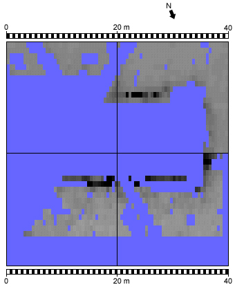
FIG. 4.1 St Mary’s nave resistivity survey results (high resistance in black)
(Image: author)
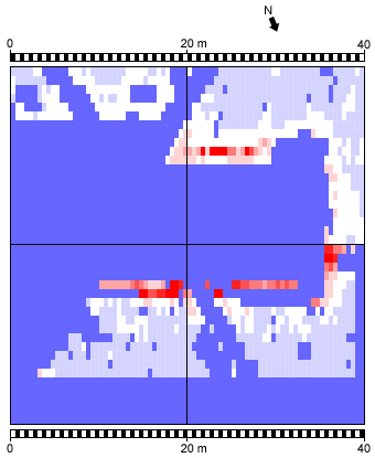
FIG. 4.2 St Mary’s nave resistivity survey results (high resistance in red)
(Image: author)
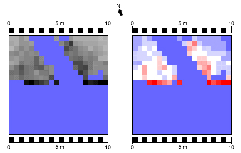
FIG. 4.3 Detailed 10 x 10 m resistivity survey of north side of nave
(high resistance in black and red)
(Image: author)
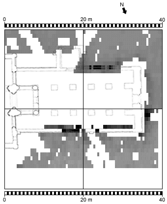
FIG. 4.4 Composite image of resistivity survey results and church plan
(Image: author, after Norman 1955)
CHAPTER 5
Standing-Building Survey
Having established the plan of St Mary’s nave prior to its loss, the analysis of the fabric of the present west front serves to illustrate the nature and date of the nave’s restructuring following its ruination.
As seen today, the present west front constitutes both Norman and later work [FIG. 5.1]. The original work (c. 1130) consists of the mortared flint walls of the upper arcade and clerestory, the round-headed window in the north clerestory wall, the weatherings of the nave aisles (below the clerestory stringcourse and in the west walls of the transepts), and four round piers, of which the second pair to the west are now, in part, on the exterior of the church (Marshall 1915: 8–10). Following the addition of a sacristy or chapel and a porch to the south nave-aisle around 1400 (see p. 3 above), the latest apparent addition to the nave fabric is a Rood window in the south clerestory wall, dating to around 1400–1500. This window lit a spacious Rood loft in the easternmost nave bay, one end of its Rood beam resting on a stone corbel east of the window base (Simpson 1971: 43, 45; Marshall 1915: 11; Evans 1936: 341–42). This undertaking would have been funded by the parishioners (Friar 2000: 87), and suggests that money was sufficient even after the decline of the port (see p. 2 above), seemingly confirmed by a funerary brass of a mercantile citizen and his wife of c. 1450 in St Mary’s chancel (Cheal 1921: 187–88; see also Pilmore 1891: 6; Salmon 1909: 156–57). That new additions were being made to the fabric of the nave, rather than essential repairs, during the 15th or early 16th centuries, strongly suggests that it was still standing and almost certainly complete at that time.
When considered in elevation [FIGS 5.2–5.3], the thick flint walls of this single nave bay clearly survive in section (the interruption of the external clerestory stringcourse in the south wall is particularly prominent), suggesting that the nave was deliberately truncated to its easternmost bay through controlled demolition (e.g. Rodwell 1989: 97). Confirmation that the nave was demolished is apparent in the interruption of the flint nave walls by several courses of thin yellow bricks above the remaining westernmost piers; their yellow colour is indicative of a high calcium carbonate content (i.e. chalk), thus the use of local clay (Smith 1985: 44). These bricks are not part of the original nave walls, but instead appear to have been laid in place of the demolished arcade arches which sprang from the piers on both sides at that point [FIGS 5.4–5.5]. The bond of the bricks (the way in which they are arranged) is of considerable significance in terms of their dating, and thus that of the arcade’s demolition, for whilst those above the northern pier are of English bond, those above the southern pier are of Flemish bond, the latter style appearing in England only after the early 1630s (Woodforde 1976: 64, 74–7, 84; Smith 1985: 48, 50; Davey 1961: 82) [FIGS 5.6–5.7]. It may be suggested, therefore, that St Mary’s nave arcade (or at least its second bay from the tower) was not demolished and restructured until after the 1630s.
The presence of identical yellow bricks in the fabric of the present west front further facilitates the dating of the nave’s demolition and restructuring. Whilst the west front predominately constitutes re-used Caen stone from the nave, presumably made available following the nave’s demolition, the external upper tier of the west front is of a lesser build quality, being made up of numerous yellow bricks, arranged broadly in three bands [FIG. 5.3]. Though these bricks do not appear to conform to any particular bond or arrangement, one group in the lower-left portion of the gable (upper tier) appears to be arranged to form a putlog hole for scaffolding (later blocked with mortared flint) [FIGS 5.2–5.3], suggesting their integral use in, and at the time of, the restructuring of the west front, itself presumably post-1630s.
Two main architectural features are present in the west front, those of the entrance doorway and the traceried window above [FIGS 5.1–5.2]. The doorway is effectively undatable in its present position, for although the moulded stone (with beakhead decoration) used in its construction dates to the Norman period, c. 1130, it has been reshaped to form a later, pointed doorway. This may have resulted from too few segments of the original Norman doorway (perhaps that of the west end or south nave-aisle) surviving to make a suitably large round-headed arch, or that a Gothic shape was considered to be more appropriate or appealing at the time of its re-erection (Daniels 1907: 18; Simpson 1971: 41; Evans 1936: 341). This entrance would have replaced the large south porch, by then assumedly also in a state of decay and demolished with the nave (the remaining porch walls appear distinctly uniform, as if systematically razed) [FIGS 2.3–2.4].
The window above this doorway is also pointed, but is in the Perpendicular style. Previous writers have assumed that the construction of this window dates to the time of the nave’s restructuring, during the late 1400s (Adams 1891: 19–20; Salmon and Pilmore 1902: 28, 31; Harrison 1920: 181). Close observation of the internal base of this window reveals that it was constructed, or rather inserted (Simpson 1971: 41), upon several courses of thin bricks, a number of which match the yellow bricks discussed above. An identical window is also present in the south wall of the south transept, the flint walls either side of which (though whitewashed) have clearly been disturbed by the inclusion of further courses of comparable yellow bricks. Both these windows, therefore, appear to have been inserted at one time, and based on the dating of the yellow bricks, after the 1630s. It may be suggested, then, that these (re-used) windows pre-date both the loss of the nave and the restructuring of the present west front, their existence appearing to further confirm the development and embellishment of St Mary’s nave, rather than its demise, in the later medieval period (see p. 10 above). The careful dismantling and re-erection of these two Perpendicular windows further suggests that the demolition of the nave was carried out with some considerable care and proficiency. Indeed, it is clear that this systematic reclamation, and the ensuing rebuilding of the present west front, would have been undertaken with scaffolding and lifting machinery, the putlog holes of the former being depicted in various 18th- and 19th-century engravings, at that time remaining unblocked (e.g. British Library Add. MS. 5673, fol. 43; Hudson 1980: facing 113).
It may be suggested, then, that the use of these thin yellow bricks in (1) the demolition of the remaining arcade, (2) the construction of the west front with putlog scaffolding, and (3) the insertion of the present west window (and that of the south transept), is of one time and single enterprise, the whole scheme post-dating the early 1630s.
The nature of the work undertaken at the time of the nave’s restructuring is further illustrated by the non-brick fabric of the west front. When viewed from the interior, where the west front abuts the western nave arches, mortared flint work is visible, suggesting that the Caen façade of the west front is, in fact, merely the fascia of a rubble-core of flint. This follows the original method of constructing walls at the time of the nave’s construction in the Norman period (Hislop 2000: 37), as testified by the remaining rubble-core of the original nave west-end wall at the rear of the churchyard [FIG. 8.2]. The quantity of Caen stone used to face the restructured west front, however, suggests that the nave was not left derelict for a sufficient period of time as to encourage stone robbing en mass, as may be expected over many centuries (Barker 1993: 20; Glossop 1928: 3; Simpson 1971: 20; cf. p. 2 above). Nor does this re-used stonework exhibit any clear indication of pre-demolition alteration or damage, such as reshaping, or blackening by fire.
The nave aisles were not filled with Caen stone but mortared flint alone [FIG. 5.1] (whitewashed on the interior), a common method of consolidating churches in post-medieval times (Rodwell 1989: 70). Further flint work (chamfered with red bricks and whitewashed) appears to have been constructed internally along a line below the capitals of the western nave piers, perhaps to serve as buttresses, supporting the flint infilling or preventing the two surviving nave arches from collapsing. Whilst this work most likely dates to the restructuring of the west front, it is also possible that the nave aisles may have been blocked to their full length prior to this date, the aisles being first to be made redundant in a deteriorating church (Rodwell 1989: 70; e.g. Farrant 2001: 262).
The single remaining nave bay at St Mary’s, demolished and restructured at one time after the early 1630s, appears to have been preserved, then, in order to serve both as a buttress to the surviving two-storey central tower (the minimum requirement for its safe support) and as a covered way into the church following the loss or demolition of the large south porch (Simpson 1971: 21, 23; Sharpe 1861: 6; Hislop 2000: 44).
Summary of Demolition and Restructuring
- The Rood window of c. 1400–1500 suggests that the nave was still standing and complete at that time
- The presence of two re-used Perpendicular windows further confirms the development and embellishment of the nave, rather than its demise, around the late 1400s
- The Flemish bonded brickwork in place of the south arcade arch of the second nave bay indicates a date of demolition and restructuring after the early 1630s
- Similar bricks underlying the Perpendicular window in the internal middle tier of the west front and surrounding one or more putlog holes in the external upper tier suggest a comparable date for the west front’s demolition and restructuring, after the early 1630s
pre-1630s post-1630s
Nave arcade demolished x
West front middle tier built x
West front upper tier built x
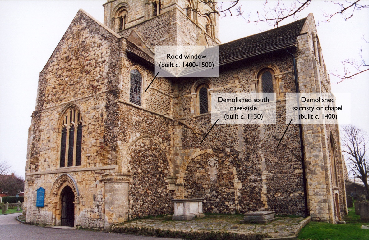
FIG. 5.1 St Mary’s present west front, showing the late Rood window,
and the demolished south nave-aisle and sacristy/chapel (Photo: author)
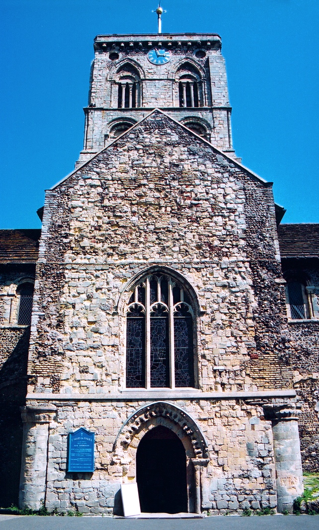
FIG. 5.2 Elevation of St Mary’s restructured west front
(Photo: author)
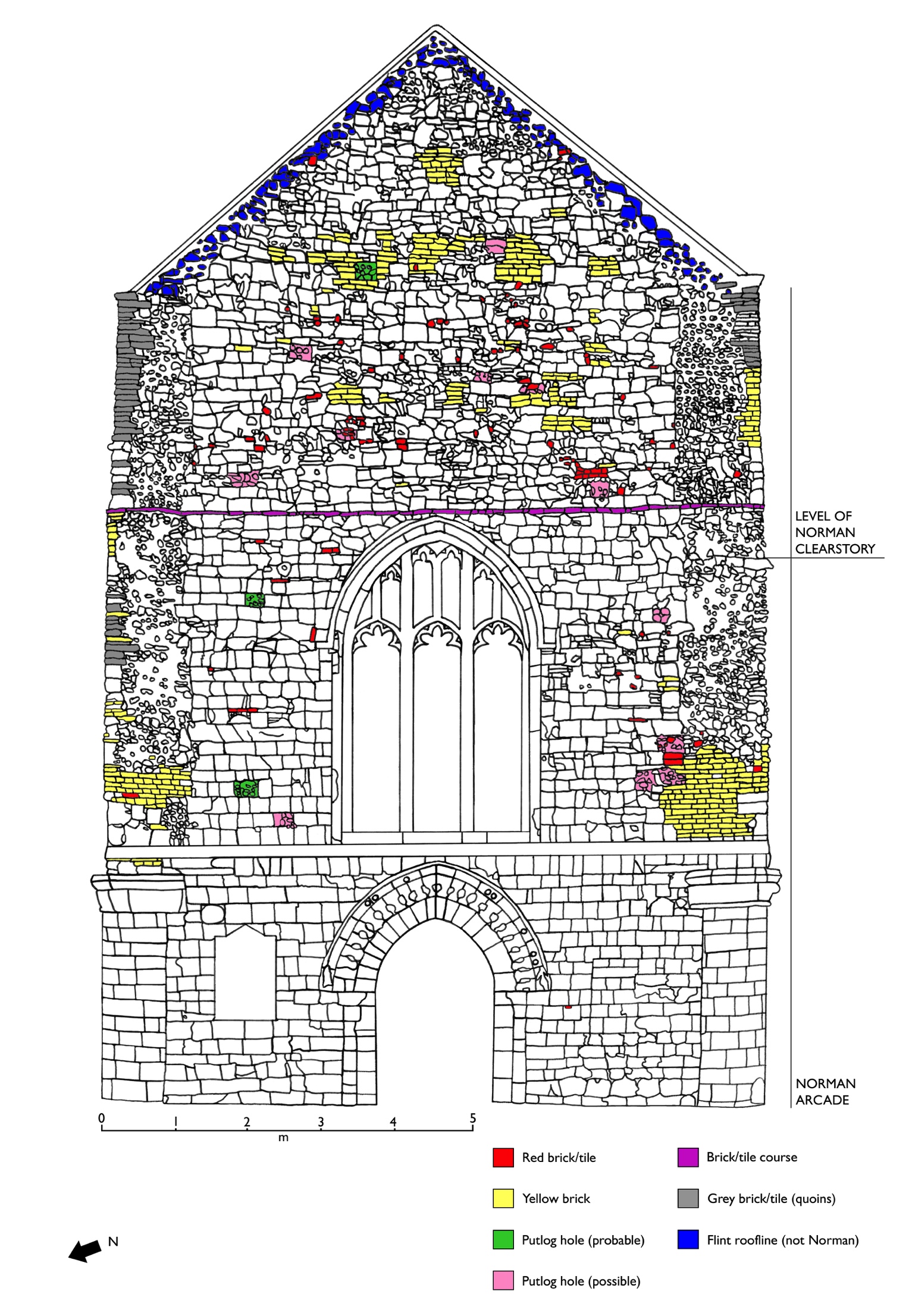 FIG. 5.3 Stone-by-stone analysis of St Mary’s restructured west front
(Image: author, after FIG. 5.2)
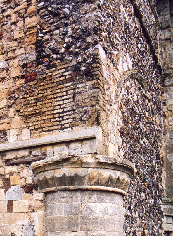
FIG. 5.4 South-western nave pier arch replaced by bricks (front view)
(Photo: author)
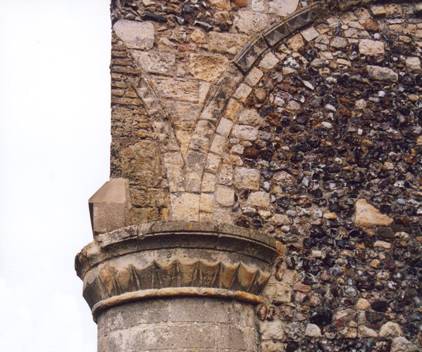
FIG. 5.5 South-western nave pier arch replaced by bricks (side view)
(Photo: author)
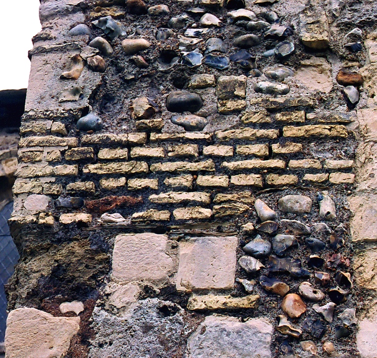
FIG. 5.6 English bond brickwork over the north-western nave pier
(Photo: author)
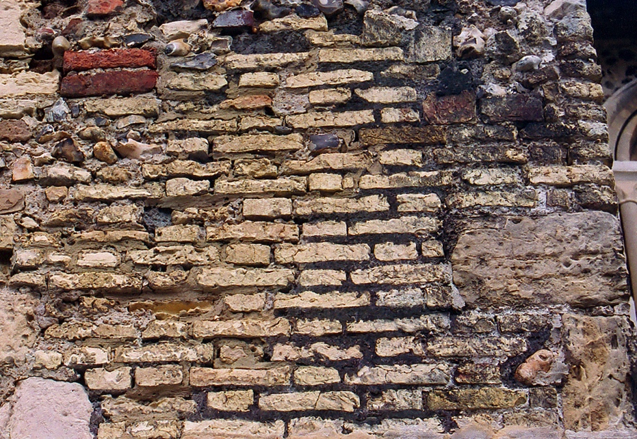
FIG. 5.7 Flemish bond brickwork (post-1630s) over the south-western nave pier
(Photo: author)
CHAPTER 6
The Loss of the Nave: documentary evidence
The majority of work previously undertaken in relation to the loss of St Mary’s nave has been based on historical research alone (see p. 2 above). This has led to the drawing of several fallacious conclusions based on certain pieces of unreliable source material, such as the stylized Jacobean chimney-piece in Marlipins Museum (see p. 2–3 above). Cartographic evidence has also proved to be of little effective use in this study (though thoroughly researched in the British Library, the British Museum, and the West Sussex Records Office), with churches being portrayed as a limited series of schematic and generally inaccurate shapes (e.g. Scott and Barty-King 1985; Woodcock 1988: 38–9 n. 8). It would appear, therefore, that documentary evidence is the only specific, though ambiguous, source of primary historical information relating directly to the loss of St Mary’s nave.
Following the time of its construction around the early 12th century, the first direct reference to the condition of St Mary’s Church comes in a series of episcopal documents dating to the last quarter of the 17th century. Between 1674 and 1677, four ‘bills of presentment’ (or ‘presentments’) were recorded by the then churchwardens of St Mary’s prior to the visitation of Archdeacon Tobias Henshaw in those years. These presentments were copied into a bound parchment by a diocesan clerk or registrar shortly afterwards, and it is this book, rather than the original presentments, which survives today (Johnstone 1949: xxi–ii).
One of the functions of presentments was the reporting of the (usually poor) condition of a parish church, its churchyard, and incumbent’s house (Johnstone 1949: xxxii–iv, xxxvi). St Mary’s first presentment, from 1674, is recorded as “Presentment nil” (Johnstone 1950: 4). It would appear that the churchwardens either found no fault with the church, or that they failed to return their presentments, in that year. The latter appears more likely in view of the second half of the presentment from the following year, 1675, by which time St Mary’s was clearly in a neglected state:
Our church is much out of repaire and the churchyard not well fenced
(Johnstone 1950: 19).
The next presentment, from 1676, is again recorded as “Presentment nil” (Johnstone 1950: 43). However, based on the content of the Old Shoreham presentment from that year (Johnstone 1950: 43), it may be suggested that the latter was erroneously copied by the diocesan clerk (or clerks) who compiled the Lewes archdeaconry presentment book, confusing or misreading Shoreham Vetus (‘Old Shoreham’) for Shoreham Nova (‘New Shoreham’). This suggestion is supported by the clear mistake between the two names in the 1675 entry the year before, where the epithet ‘NOVA’ in the heading SHOREHAM NOVA was overwritten as if originally in error, perhaps mistakenly written as ‘VETUS’ in the first instance (see the original manuscript, DRO 54/II/15/2, in the West Sussex Records Office).
The 1676 Old Shoreham presentment was recorded as follows:
Church a great part of it is fallen downe and the rest in greate danger of falling, if some speedy
corse be not taken to prevent it. The bells are all broken excepting one. The parsonage house hath
bin for many yeares past totaly ruined and fallen downe
(Johnstone 1950: 43).
Reference to the collapse of “a great part” of the church is far more indicative of St Mary’s than Old Shoreham Church, for unlike the former, St Nicolas’s has never been without its nave (testified not least by the Saxon work still in situ within the nave’s fabric), and only ever having lost a portion of its south transept and two small out-chapels (Simpson 1971: 33–7; Cheal 1921: 167). Indeed, ten years after this presentment was written, in 1686, St Nicolas’s nave is recorded as intact, but St Mary’s is not (Ford 1994: 34–5).
Further evidence that the 1676 presentment refers to St Mary’s comes in the second half, with reference to the church bells being “all broken excepting one”. It seems improbable that this could apply to St Nicolas’s, for it had only one bell (or at most, two), whilst St Mary’s had at least four bells at that time (Simpson 1971: 31; Ford 1994: 35). Reference to the collapse of the vicarage (“parsonage house”), furthermore, confirms the presentment’s association with St Mary’s, for in 1724, New Shoreham vicarage was recorded as having fallen down “about 60 years ago”, thus prior to the 1676 presentment, around c. 1664. St Nicolas’s vicarage, however, was recorded as still standing in 1724, having not previously collapsed (Ford 1994: 151). It may be concluded, therefore, that the 1676 presentment assigned to Old Shoreham, in fact, relates to New Shoreham and St Mary’s Church, and that “a great part” of the latter can reasonably be assumed to refer to the loss of its nave by that date, 1676.
The presentment from the following year, 1677, clearly confirms the destitute state of St Mary’s. The second half of the document records that long-overdue repair work was being undertaken at that time:
The parish church hath bin for many yeares in a very ruinous condicion; the churchwardens are
now repayring the same
(Johnstone 1950: 59).
By analogy with the dilapidated condition of St Mary’s vicarage “for maney yeares” by 1676, the ruined state of St Mary’s also “for many yeares” may similarly date to around the mid-1660s (see above), though whether reference was being made to the nave specifically is unclear. The nature of the churchwardens’ repairs carried out in 1677 is not recorded, but appears to refer to the prompt preventative course alluded to in the 1676 presentment, in the previous year (see p. 17 above). As was no doubt known to the churchwardens, the preservation of the remaining portion of the church would have best been assured through the repair of its roofing, as the first part of a decaying building to give way and a major catalyst for the deterioration of the fabric below (Barker 1993: 19–20). That the repair work of 1677 took the form of repairing at least one roof is suggested by a lead plaque inscribed with the names of the churchwardens, Richard Herring and William Harfill, in that year (Simpson 1971: 45; Salmon 1909: 162; see also Braun 1970: 224)
[FIG. 6.1].
It has been suggested that it was not the nave roof but that of the chancel which was re-leaded at that time, the plaque being preserved following its later re-roofing (Cheal 1921: 194–95; Salmon 1909: 162). This would appear to confirm the need to repair the remainder of the parish church (see the 1676 presentment, p. 17–8 above), and notably the chancel, assumedly the only sizeable portion of the church usable for services by that date. Recent architectural analysis of the chancel vault indeed suggests that the chancel was at some time without its roof (Andrews 2003: 62), thus probably around the later 17th century.
The condition of St Mary’s nave is next reported in 1686 (a decade after it is recorded as having fallen), not in a churchwardens’ presentment but a church survey conducted under the auspices of John Lake, the then Bishop of Chichester (Ford 1994: 1–4). The purpose of the survey was the recording of “defects” in the fabric and contents of the churches visited (Ford 1994: 34). St Mary’s (recorded as ‘New Shoreham’) was inspected on October 14th 1686, the first ‘defect’ relating to the condition of the church fabric:
The passag into the body of the church utterly ruinate. Floor of chancel unpaved
(Ford 1994: 35).
This short reference is highly ambiguous and is open to considerable interpretation. In the 17th century, the ‘body’ of a church referred to the main portion of the building when considered as a whole, thus the ‘nave’, though not including its aisles (Simpson and Weiner 1989a: 354, II.8; Simpson and Weiner 1989b: 256). Similarly, the ‘passag(e)’ meant the route or way into the nave, the central aisle of the nave itself being described in this way (e.g. 1627–28: “The open passadge in the middell of the Churche”, Simpson and Weiner 1989c: 301, II.11.a; cf. Ford 1994: 38). The 1686 survey offers the only direct reference, then, to a specifically ruined portion of St Mary’s nave. As the only direct way into the nave, the west entrance at the rear of the nave may have been ruined by this date, but does not appear to constitute the fall of a “great part” of the nave, as recorded in 1676. It is perhaps more likely, therefore, that the commissioners were referring to the nave’s wide central aisle in 1686, as the route into or along the nave, its associated arcade and clerestory sections by that time in ruins. It would appear, then, that neither repair work nor demolition were carried out on the nave in the 1667 repairs (see p. 18 above), the remaining fabric of the nave still standing in situ, though in a ruinous state, as late as 1686.
The first quarter of the 18th century heralds a period of substantial repair work at St Mary’s. On March 11th 1713/4, application for a Brief was proposed at a vestry meeting under the newly-appointed Revd Rice Williams (‘Rice’ then transcribed for ‘Rhys’), the decision to attend to the necessary requirements being written into the parish vestry book of 1707–1779:
… to manage and solicit in all matters that shall be needfull for the obtaining of a Brief for the
repairing of our sd church…
(Salmon 1908: 165).
A Brief was a legal licence allowing the collection of money (usually for one year) for parishes in need of financial assistance after serious loss (Bewes 1896: 6; Turner 1869: 208). Application for a Brief could be made at the time of loss or later (e.g. a Brief was issued in 1710 for the rebuilding of the Church of St Mary-at-the-Walls in Colchester following its ruination in 1648 during the Civil War, Bewes 1896: 34–5, 303). The success of Briefs was varied, many falling short of their financial target and all being reduced by the excessive administrative costs which they entailed, often almost halving the totals collected (Turner 1869: 210; Bewes 1896: 34–7). The response to St Mary’s Brief appears to have been accordingly meagre, based on the surviving records of the four parishes which gave money (between October 1714 and February 1714/5). Responding to the appeal for the sum of £2,203 towards the repair of unspecified “damage” or “damages”, the total amount raised was less than £3 (Simpson 1971: 21; Turner 1869: 211, 214; Bewes 1896: 305). Other parishes may have offered financial support to St Mary’s, though, the final total of the Brief perhaps being greater than surviving records suggest. Briefs issued for ‘damage’, as for St Mary’s, appear to relate to certain specific events such as fires, or natural occurrences such as storms and inundation by the sea (Turner 1869: 211, 217). However, the year before St Mary’s Brief, in 1713, another Brief for “damage” to the sum of £1,510 was granted to Southover Church in East Sussex following the collapse of its tower in 1698, the money collected going towards its rebuilding (Turner 1869: 214). The 1714 Brief for St Mary’s, then, may have been granted for the repair of fallen parts of St Mary’s nave, or indeed by that time, its chancel.
The total of £2,203 for the Brief, though a large sum of money in the early 18th century, is relative to the projected cost of other Briefs issued for church repairs, some even rising beyond this figure to around £4,000–£5,000 (reaching a massive £26,366 towards Llandaff Cathedral in 1732) (Bewes 1896: 305; Turner 1869: 214). St Mary’s Brief, therefore, was most likely intended for relatively small-scale work (cf. Simpson 1971: 21–2). Indeed, the repair of the chancel rather than the nave would have been of the utmost importance, by that time certainly serving as the parish church alone, being used for services rather than the dilapidated nave.
The work carried out on St Mary’s following the 1714 Brief is not recorded. That it was complete by 1720 is evident, however, from a description of New Shoreham by John Owen in an atlas of counties and roads published in that year:
The Parish Church… has lately been repaired and greatly beautified by the Voluntary contributions
and at the expense of the Inhabitants, to their great credit
(Simpson 1971: 23).
The last money given towards the Brief was recorded in February 1714/5 (Simpson 1971: 21). That the church had “lately been repaired” by 1720 appears to suggest that the work carried out on St Mary’s was begun, and perhaps completed, around 1715 (Marshall 1915: frontispiece).
St Mary’s is first officially recorded as being in a good state of repair at the time of the episcopal visitation under Thomas Bowers, Bishop of Chichester, between June and August 1724:
The church in good order, and handsomely beautified of late by a brief; otherwise to be done by the
parish… The chancell in good order, and handsomely beautified of late by a brief; otherwise to be
done by the parish also
(Ford 1994: 150–51).
This survey was particularly concerned with the condition of the fabric of the churches surveyed (Ford 1994: 1), and may accordingly be taken as a more reliable account than John Owen’s description four years previously (i.e. that the parishioners funded the work). The good condition of St Mary’s nave and chancel was commented upon separately in 1724, the former being referred to as the “church”, and the latter, the “chancell”. Thus, the work of c. 1715 appears to have benefited the parish church as a whole, it being generally “beautified” (a common 18th-century term, i.e. improved aesthetically) around that time (Beevers et al. 1989: 55; Simpson and Weiner 1989a: 37–8; e.g. Ford 1994: 225–26). By the first quarter of the 18th century, then, St Mary’s nave appears to have been in good order, for the first time in its recorded history.
As already noted in the standing-building survey (see Chapter 5 above), the nave appears to have been both demolished and restructured at one time after the 1630s, the present west front being blocked with re-used materials from the nave after demolition. Thus, for the nave to have been in a ruined condition, though with much of its fabric still in situ, as late as 1686 (see p. 19 above), it would appear that the nave was not demolished or restructured until after that time, most probably in the works of c. 1715. This suggestion appears to be confirmed by the founding of a Charity School in the clerestory level of the south transept in 1714 (Salmon 1908: 179–81). At that time, a doorway appears to have been built into its south wall (most likely to provide access), and a re-used Perpendicular window inserted above it (presumably to light the lower portion of the transept, the clerestory windows being blocked by the wooden floor of the school) (Marshall 1915: 13; Salmon and Pilmore 1902: 35–6; Glossop 1928: 4). This 15th-century window is further surrounded by post-1630s bricks (see p. 11 above), suggesting that both this window and that of the present west front were re-used and inserted around 1714–15 [FIG. 6.2].
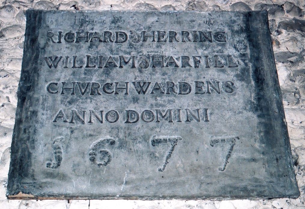
FIG. 6.1 Lead plaque from re-leading the chancel roof in 1677
(Photo: author)
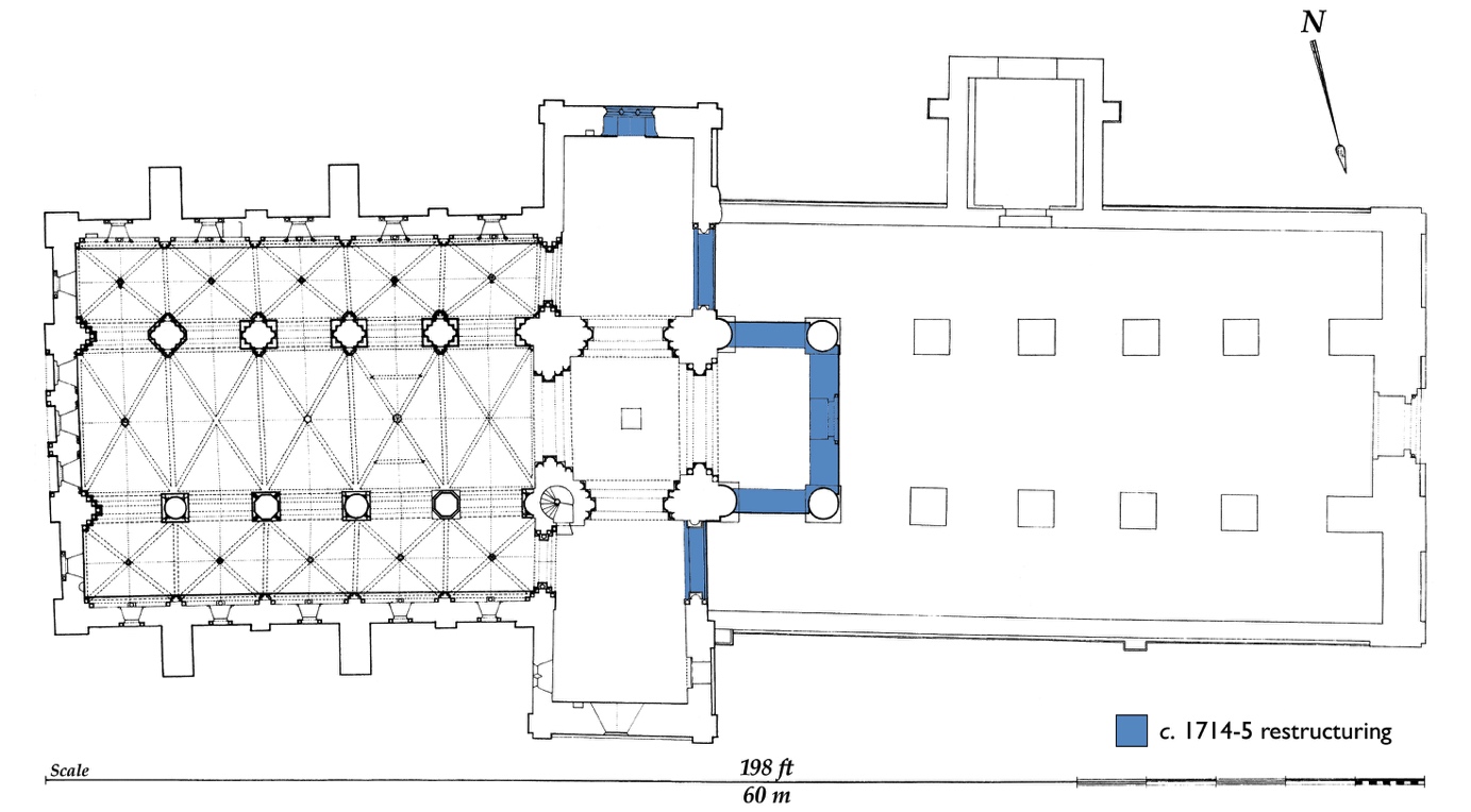
FIG. 6.2 Plan of St Mary’s restructuring in c. 1714–15
(Image: author, after Norman 1955)
CHAPTER 7
The Loss of the Nave: probable cause
Having reviewed and analysed the archaeological and historical evidence for the date of the ruination of St Mary’s nave, one fundamental question remains, however, concerning the probable cause of the loss of the nave.
The standing-building survey and historical evidence together suggest that St Mary’s nave may have been intact as late as the early 16th century, though clearly having fallen by the late 17th century. This period, c. 1500–1676, encompasses a number of potential causes for its loss, central to which are the Reformation of the mid-16th century and the Civil War of the mid-17th century.
The Reformation was a period of considerable change and upheaval within parish churches, though it has not been directly attributed to the loss of St Mary’s nave (Adams 1891: 18; Cheal 1921: 186). Collegiate churches were most severely affected, in some cases with the abandonment of their naves (formerly serving as the parish church), as at Boxgrove Priory in West Sussex and St Bartholomew the Great in the City of London, their choirs instead being adopted for parochial use (Popham 1954: 8; Friar 2000: 312). It seems unlikely that St Mary’s, as a non-collegiate church, was affected in this way, though its unusually large chancel was of a sufficient size in itself to accommodate its parishioners. The late restructuring of the nave, in the early 18th century, and the lack of stone robbing prior to that time (see p. 11 above), further suggest a date later than the Reformation for the loss of St Mary’s nave.
The Civil War of the 1640s, however, has been suggested by several writers as a likely cause, or contributing factor, of the loss of St Mary’s nave (Adams 1891: 19; Pilmore 1891: 9; Green 1877: 75; Nairn and Pevsner 1965: 276; Simpson 1971: 19–20; Smith et al. 1976: 48; Woodcock 1988: 35). The town of New Shoreham was resolutely Parliamentarian in the Civil War, and was fortified by defensive works and heavy cannon to safeguard both the South Coast seaway from King Charles I’s Continental mercenary forces and supplies, and the River Adur as a line of communication and frontier against the Royalist advance from the west (Thomas-Stanford 1910: 64–5, 73, 75; Armstrong 1995: 95, 98; Howard 1999: 58–9). Several hundred troops, many with horses, were accordingly posted in New Shoreham and at nearby Bramber Bridge (the sole river crossing) under high command throughout autumn and winter 1643/4 (Fletcher 1975: 267–68; Thomas-Stanford 1910: 75, 78; Scott and Barty-King 1985: viii–ix). As with other churches in the Civil War, St Mary’s nave may perhaps have been used for garrisoning troops, wintering horses, imprisoning enemy soldiers, or storing supplies and munitions (Porter 1994: 131; Braun 1970: 212; Child 1982: 16; Friar 2000: 412). Indeed, St Mary’s parish registers, in serious disarray around the time of the Civil War, record the burial of two Parliamentary Captains and six soldiers in St Mary’s churchyard in January 1643/4 (Woodcock 1988: 35; see also Gordon 1876: 101–02). Whether or not killed in combat, these burials suggest that Parliamentarian forces continued to control the vicinity of St Mary’s churchyard at that time (Harrington 1992: 52).
Churches were also fortified and defended during the Civil War, and some even besieged or set on fire (Porter 1994: 15, 22–3, 26, 46; Harrington 1992: 32–3; Child 1982: 16; Howard 1999: 58; Friar 2000: 412). Two churches in nearby Chichester were recorded in the later 17th century as having been destroyed and demolished in the conflict (WSRO Ep. III/7/2; WSRO Ep. III/7/5; see also Porter 1994: 42, 65–6). St Augustine’s Church at Dodderhill in Worcestershire was set alight, its nave alone being ruined, as reported in 1674: “the body of the church… was fired and destroyed by the soldiers in the time of the late distractions and is not rebylt yet. But the chancell and what remains is in good order” (Porter 1994: 120–21; cf. p. 19 above). Whilst St Mary’s is similarly without its nave, and its chancel remains intact, there is no evidence that this situation resulted from fire damage, deliberate or otherwise (see p. 11 above). The Brief issued to St Mary’s in 1714 for “damage”, though perhaps relating to Civil War damage (as in the case of other Briefs issued in the early 18th century, see p. 19–20 above), does not explicitly state ruination by fire (see p. 19 above). Nor are there any clear archaeological indications that St Mary’s was either besieged or attacked, as may be suggested by earthworks or shot marks (e.g. Harrington 1992: 31–3). The Civil War, therefore, can only be cited speculatively as the cause of the loss of St Mary’s nave.
The Commonwealth (1649–60) marks more generally a period of neglect in parish churches, resulting in the severe decay or collapse of many by the time of Restoration of the Monarchy in 1660 (Friar 2000: 412; Ford 1994: 8–9). St Mary’s large nave may have similarly succumbed to a lack of maintenance and repair during this period. Indeed, the fall of both St Mary’s nave and vicarage during the mid-1660s, suggested by the churchwardens’ presentment in 1677 (see p. 18 above), appears to indicate the neglect of New Shoreham’s religious fabric during the Commonwealth. The Restoration does not appear to mark a change in the condition or care of St Mary’s, for from c. 1662, following the ejection of the second Intruded Minster (non-Anglican Puritan), the living was sequestrated and no Anglican incumbent appointed until 1670, even then as a non-resident Curate-in-Charge from nearby Southwick (Cheal 1921: 200–01; see also Howard 1999: 59; Friar 2000: 412).
Throughout the period of the Civil War, Commonwealth, and Restoration, the responsibility for the upkeep of St Mary’s nave continued to lie with the churchwardens and parishioners (Friar 2000: 87, 108; Child 1982: 15), yet it would appear that they failed in their duty during this troubled period, being perhaps either unable or unwilling to maintain or repair it. The latter is suggested by a revealing letter written slightly later, in 1686, by the then Bishop of Chichester, in which the apparently negligent inhabitants of New Shoreham, numbering 500 in 1676, are described as “the heathens of Shoreham” (Cooper 1902: 145; Woodcock 1988: 35–6). Thus, it was perhaps due to the failing of the churchwardens and parishioners, as well as the dilapidated state of St Mary’s nave, that no incumbent could be tempted to fill the vacant position (known as the ‘vicarage’, though not referring to the house) following the Restoration in 1660 until 1713 (Woodcock 1988: 36), from which time alone action appears to have been taken on St Mary’s ruined nave under Revd Rice Williams (see p. 19 above).
Finally, though the ‘Great Storm’ of 1703 has also been held accountable by some for the fall of St Mary’s nave (Simpson 1971: 20; Hudson 1980: 171; Woodcock 1988: 35, 41 n. 17), this seems improbable, even in part, in view of the nave’s collapse by 1676.
The most likely cause of the nave’s loss, then, appears to be a severe lack of repair work by the churchwardens and parishioners from the mid-1640s, culminating in its probable total neglect at the time of both the sequestration and the collapse of St Mary’s vicarage (house) during the mid-1660s. Indeed, this troubled period is epitomized by a number of dated and initialled graffiti in St Mary’s chancel, from 1645 to 1669 (Salmon 1905: 146). It may be further suggested that between the 1660s and c. 1714–15, the fabric of the nave continued to deteriorate, falling into such serious decay that its demolition was deemed necessary by the early 18th century. It is unclear, therefore, to what extent the nave was intact prior to its demolition, further complicating the analysis of its demise and ruination.
Summary of Loss
deterioration of
ruined fabric?
1640s 1660s 1676 1714–15
neglected? collapsed? ruined demolished
CHAPTER 8
Public Archaeology Survey: a future for St Mary’s nave?
Having established what I consider to be the most plausible date and cause of the loss of St Mary’s nave, the final part of this study, fulfilling the second research question (see p. 1, 6 above), concerns the future of the nave as an archaeological site, of potential interest to visitors, parishioners, the local community, and the general public alike.
The idea of regenerating St Mary’s ruined nave is not unique to this study. As long ago as the early 18th century (1713), Revd Williams and his committee appear to have taken the decision to demolish the unsafe portions of the nave, re-using the material to form the present west front, with apparent unanimous acceptance and praise (see p. 20–1 above). Whilst this might today be considered to be a somewhat drastic solution, it might equally be questioned why the nave was not left as a ruin in the 18th century, so high was the regard Romantics paid towards ruins, even those artificially created, at that time (e.g. Farrant 2001: 167–68, 262). It may perhaps be suggested, then, that the remaining flint west wall of St Mary’s nave was preserved as a romantic conceit at the time of demolition (c. 1714–15), rather than being left to stand for any practical reason
[FIG. 8.2].
A number of trees appear to have been planted within the vicinity of the standing ruin at the rear of the churchyard in the early 19th century (Pilmore 1891: 9; Salmon and Pilmore 1902: 35), though the Victorian solution of the later 19th century (1866 and 1876), in contrast, was the proposed total rebuilding of St Mary’s nave at a cost of £9,800–£10,000 (Woodcock 1988: 56–8; WSRO Par 170/4/3). Two reasons were given in support of this latter course of action, firstly to reflect the revival of New Shoreham’s port at that time by the renewal of its similarly once-great parish church, and secondly due to the then “greatly deficient accommodation of the parishioners” within the chancel alone (WSRO Par 170/4/3). It would appear, though, that the latter reason was not sufficient to save the project from a lack of funds, or indeed abandonment from the outset (Woodcock 1988: 56, 58, 65 n. 25; Pilmore 1891: 9). The plans and designs of the architects, Mr Slater and Mr Carpenter, have been preserved, however, and are of particular interest (WSRO Acc 8373).
No attempt has been made to restore St Mary’s nave since that time, and little appears to have been done to preserve what remains. Photographs from the early 20th century reveal a far less congested space in the area of the nave, with considerably fewer trees [FIG. 8.1]. Today, however, a number of large self-set Ash trees pose a threat to the integrity of several surviving sections of the nave west wall. The removal of these particular trees on conservation grounds (though themselves protected within a nature conservation area) has been discussed with Martin Brown, Chichester Diocesan Archaeologist (cf. p. 1 above), and representatives of Adur District Council. Three Yew trees, planted in Victorian times, have similarly been left to grow to an unsuitable height, and themselves now conceal the standing section of the nave west wall from a number of potential vantage points, not least from within the church (e.g. Child 1982: 68–9). Furthermore, as recently as 2000, the standing section of ruined nave west wall was cleared of dense ivy on the instruction of English Heritage (Ian Tompkin, churchwarden, pers. comm.). At the time of writing (2003–04), the ivy is re-establishing itself at a noticeable rate.
Less still, perhaps, has been done towards the presentation of St Mary’s ruined nave to the public, though like the chancel, it too is Grade I listed and is a site of great historic and local significance (e.g. Baker 1999: 100). At some time in the recent past, a wooden bench has been sited inside the ruined nave close to a public pathway which crosses through the churchyard, and the District Council have placed metal railings around the remaining portion of the standing west end, near to which a somewhat objectionable sign requests that the ruins should not be climbed upon but provides no information about what the fenced stonework represents [FIG. 8.2]. No attempt has been made to develop the site in the style of other ruined ecclesiastical monuments (e.g. English Heritage properties) by gravelling or paving the nave for its better conservation and public interpretation (e.g. Rowley 1997: pl. 11a). A computerized image of St Mary’s nave after gravelling has accordingly been produced [FIG. 8.3].
The final part of this study, then, undertaken at the start of the 21st century, considers a series of new solutions for the possible future development of St Mary’s nave. In order to gauge public opinion in relation to the proposed schemes, a public archaeology questionnaire of 50 visitors and 50 parishioners of St Mary’s was undertaken in August 2003. The results of the survey, expressed as percentages (i.e. doubled) in the discussion, appear in a series of statistical charts below.
Public Archaeology Questionnaire
Q1: Are you: a visitor/a parishioner?
Q2: Have you been to the church before today: never/occasionally/ frequently?
Q3: Did you know that half the church fell down several centuries ago: yes/no?
Q4: Have you seen any of the remains in the churchyard: yes/no?
Q5: Would it be a good idea to give the public more information about the ruined nave
area: yes/no/maybe?
Q6: Which of the following ideas would help to reconnect the ruined nave with the
present-day church: outdoor information panels/creation of an open space/paving the
nave area/leave?
Q7: Are you: male/female?
Q8: Are you: under 20/20–40/40–60/60 and above?
The first question was designed to give an even outcome (i.e. 50 visitors and 50 parishioners), and is, therefore, not represented graphically. The response to the second question, concerning the frequency of previous visits to St Mary’s, however, generated a very different outcome, with the majority of visitors (46%) coming to the church for the first time, whilst only a few parishioners (4%) had not been before (presumably living in the parish but not attendants of St Mary’s) [TABLE 1]. This immediate discrepancy between the number of times visitors and parishioners had previously been to St Mary’s must be borne in mind in relation to the following two questions, which are considered together as they lead directly on from one another. The third question asked whether it was known that the church was incomplete due to its fall in a previous century (i.e. the nave, though not stated at that point); the fourth asked if any remains had been seen in St Mary’s churchyard. The difference between the responses to these two questions by the visitors and parishioners was again marked, the majority of visitors in both cases neither realising that the nave was ruined (64%) nor apparently seeing any remnants of it during their approach into the church through the churchyard (56%). The vast majority of parishioners, conversely, were both aware that the nave had fallen (84%) and that surviving portions are observable within the churchyard (90%) [TABLES 2–3].
The fifth question was answered identically by both visitors and parishioners alike, with a clear majority (92%) supporting the public being given more information about St Mary’s ruined nave [TABLE 4]. This equal response is interesting in view of the discrepancy of knowledge held by visitors and parishioners about St Mary’s (see above). Similar, too, were the responses by both groups to suggestions concerning the nave’s possible future development. From a list of four broad ideas – relating to the erection of outdoor information panels, the creation of an open space (i.e. without trees or grave stones), paving the nave, or leaving the nave undeveloped – by far the most popular amongst both visitors and parishioners was the future introduction of information panels (52%), followed by the paving of the nave (32% visitors and 28% parishioners) [TABLE 5]. The last two questions, seven and eight, concern the general demography of the visitors and parishioners, and were undertaken in order to assess the previous answers within a social framework. Thus, in August 2003, the ‘average’ visitor to St Mary’s (who completed the survey) was female (58%) and aged 40–60 (38%); the ‘average’ parishioner was also female (60%), but aged 60 or over (44%) [TABLES 6–7]. These figures should perhaps be borne in mind when assessing both the responses given to the previous questions and the apparent bias of the survey towards a particular social group (e.g. resulting from women completing surveys on behalf of their male partners, or the general unwillingness of men to participate in the survey).
The results of the public archaeology questionnaire prompt a timely reassessment of the future of St Mary’s ruined nave. It would appear that the majority of visitors to St Mary’s Church are unaware of the history and archaeology of its nave both prior to their arrival and, more critically, still at the time of their departure. This can perhaps be blamed in part on the overly dense coverage of foliage and trees within the churchyard, being particularly apparent during the summer visiting months, which regrettably masks the surviving portions of the nave from view both within the churchyard and the church itself. The survey has also highlighted the need, therefore, to provide suitable and visible information relating to the nave and the history of its ruination (e.g. Baker 1999: 105). Those who participated in the survey appear to unanimously favour the erection of information panels, which perhaps represents the least costly and intrusive method of presenting the nave to a broad range of interested parties, particularly from different age groups and nationalities (i.e. with the inclusion of reconstruction drawings and a multilingual text). It is hoped, therefore, that such a proposal may result from this study.
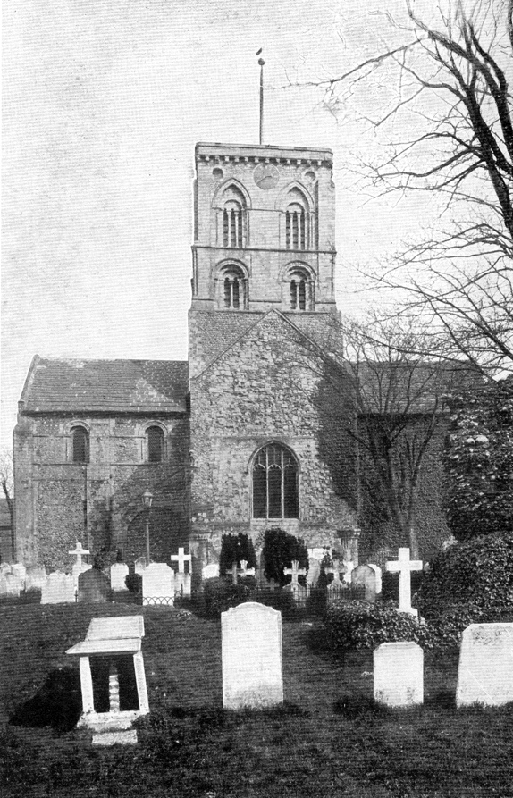
FIG. 8.1 The area of St Mary’s nave around 1907
(Photo: Daniels 1907: frontispiece)
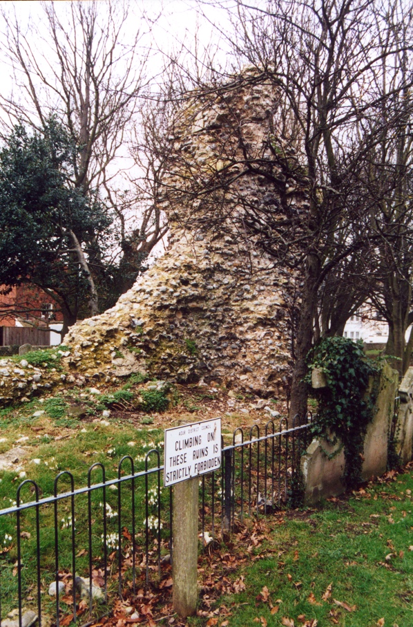
FIG. 8.2 Standing ruin of St Mary’s nave west end, behind trees and railings
(Photo: author)
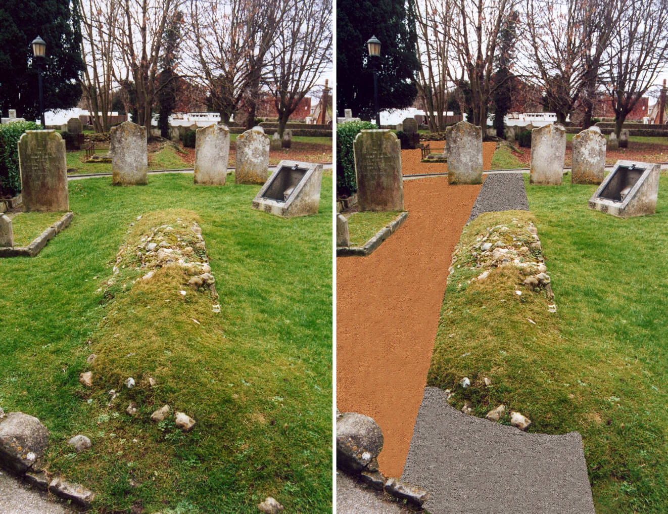
FIG. 8.3 Nave area today (left) and impression after gravelling (right)
(the walls could then be cleared of grass and consolidated)
(Image: author)
TABLE 1 Q2: Have you been to the church before today?
(Image: author)
TABLE 2 Q3: Did you know that half the church fell down several centuries ago?
(Image: author)
TABLE 3 Q4: Have you seen any of the remains in the churchyard?
(Image: author)
TABLE 4 Q5: Would it be a good idea to give the public more information..?
(Image: author)
TABLE 5 Q6: Which of the following ideas would help to reconnect the ruined nave..?
(Image: author)
TABLE 6 Q7: Are you..?
(Image: author)
TABLE 7 Q8: Are you..?
(Image: author)
CHAPTER 9
Conclusion and Future Research
The underlying aim of this work has been to modernize and reinvigorate the study of the ruined Norman nave of the Church of St Mary de Haura, New Shoreham. A number of different approaches have been adopted in order to best assess the archaeology and history of St Mary’s nave, not least in the undertaking of three distinct fieldwork components, namely a geophysical survey, a standing-building survey, and a public archaeology questionnaire.
Two main research questions underlie this study, firstly concerning the loss of the nave and its later restructuring, as in previous studies, but secondly a consideration of the nave’s future as a ruined monument of notable public and community interest. It is felt that both questions have been successfully explored and fairly answered, though future debate or the discovery of further source material (archaeological or historical) may prove otherwise.
In conclusion, a date for the loss of St Mary’s nave may be placed around the mid-17th century, between the c. 1640s and 1660s, with the demolition and restructuring of the nave (after the 1630s) around the early 18th century, c. 1714–15 (some three quarters of a century in total). The cause of the nave’s fall was most probably due to heinous neglect, over a relatively short period in the church’s history. The regeneration and development of the ruined nave as an archaeological site of public interest appears to be a suitable and fitting solution for the modern era, and one which would arguably be best achieved through the removal or reduction of certain oversized trees within the churchyard, and the erection of a series of illustrated, multilingual information panels in the vicinity of the nave.
Finally, in relation to future research concerning St Mary’s nave, it is hoped that this study will promote further work on its archaeology and history. If the prospect of excavation is more forthcoming in future years, then a similar investigation centred on an intrusive methodology may bring further, challenging results to the debate. As part of such a study, the more accurate dating of the thin yellow bricks of the west front, integral to the present work, might also be undertaken through the absolute-dating technique of Thermoluminescence. With regard to further historical research, the consultation of further 17th- to 19th-century descriptions of Shoreham and Sussex, most probably in the British Library, may perhaps be the best advancement.
Appendix
Church of St Mary de Haura, National Grid Reference: TQ216051
Resistivity surveys are conducted within a number of connecting grids of 10, 20, or 30 square metres (Clark 1996: 158–61). The survey at St Mary’s was undertaken in four grids, each measuring 20 x 20 metres, thus a total area of 1,600 square metres. In order to accurately fix the position of the grids for future reference, a baseline was established in relation to the church’s transepts, as permanent points in the survey area. The 40 m-long baseline was set back in line with the western curb of the path into the south transept, extending 6 m from the transept’s south wall to form point A of grid 1. Points B and C of the same grid were established through triangulation with 30 m tapes, from which square the second grid could be fixed (Clark 1996: 161). Due to numerous obstacles within and around the nave (such as extensive tarmac paths, trees, bushes, and graves stones), it proved impossible, however, to survey all four grids in conjunction with each other (the blue areas in the survey representing those parts of each grid which could not be surveyed). Instead, grids 1 and 2 were surveyed together, and grids 3 and 4 together, all corresponding to the fixed baseline, but with marginally different alignments at their eastern ends.
On competition of the survey grids, measurements were taken with an RM15 soil resistance meter at sample intervals of 0.5 m along each 1 m-wide traverse of the grid (Clark 1996: 162–63). A more detailed survey was also undertaken at traverse intervals of 0.5 m (with sample intervals remaining at 0.5 m) along a separate 10 m square. The technique of testing soil resistance is based upon the principal that a known electric current will pass with varying degrees of efficiency and regularity through soil according to its constitution and contents. Where the current encounters an area of high resistance (material which is resistant to the passage of the charge, e.g. rubble, walls), a high reading is recorded by the unit in that 1m- or 0.5 m-square, a low reading corresponding with low-resistance readings (e.g. backfilled cuts, graves) in each square. When transferred to a computer, these readings are aligned with the surveyed grids and an image of the survey area’s resistance produced (Clark 1996: 37, 45), in this case that of St Mary’s nave and its surrounding churchyard.
Bibliography
Adams, H.C. 1891. The History of the Shorehams, Sussex. New Shoreham.
Andrews, R. 2003. ‘St Mary de Haura: repairs to choir vault at New Shoreham, Sussex’, Church Building 83, 62–4.
Armstrong, J.R. 1995. A History of Sussex. Chichester: Phillimore.
Baker, D. 1999. ‘Churches and Cathedrals’ in G. Chitty and D. Baker (eds), Managing Historic Sites and Buildings: Reconciling Presentation and Preservation. London: Routledge.
Barker, P. 1993. Techniques of Archaeological Excavation. London: Batsford.
Beevers, D., R. Marks and J. Roles. 1989. Sussex Churches and Chapels. Brighton: Royal Pavilion, Art Gallery and Museums.
Bewes, W.A. 1896. Church Briefs. London: Adam & Charles Black.
Braun, H. 1970. Parish Churches: Their Architectural Development in England. London: Faber and Faber.
Cheal, H. 1921. The Story of Shoreham. Hove: Combridges.
Child, M. 1982. Discovering Churches. Princes Risborough: Shire.
Clark, A. 1996. Seeing Beneath the Soil: prospecting methods in archaeology. London: Batsford.
Clarke, H. 1986. The Archaeology of Medieval England. Oxford: Blackwell.
Cooper, J.H. 1902. ‘A Religious Census of Sussex in 1676’, Sussex Archaeological Collections 45, 142–48.
Daniels, H.G. 1907. Shoreham, Southwick and Steyning (Sussex), with their Surroundings. (The Homeland Handbooks 59). London: The Homeland Association.
Davey, N. 1961. A History of Building Materials. London: Phoenix House.
Evans, A.A. 1936. ‘A Countryman’s Diary’, Sussex County Magazine 10 (5), 340–43.
Farrant, J.H. 2001. Sussex Depicted: views and descriptions 1600–1800. (Sussex Record Society 85). Lewes: Sussex Record Society.
Fletcher, A. 1975. A County Community at Peace and War: Sussex 1600–1660. London: Longman.
Ford, W.K. (ed.) 1994. Chichester Diocesan Surveys, 1686 and 1724. (Sussex Record Society 78). Lewes: Sussex Record Society.
Friar, S. 2000. The Companion to the English Parish Church. London: Chancellor Press.
Glossop, J.F.G. 1928. St Mary de Haura, New Shoreham, Sussex. Shoreham: Pope & Beesley.
Gordon, H.D. 1878. ‘Further Traces, on the South Downs, of the Winter Campaign of the Civil War of 1643’, Sussex Archaeological Collections 28, 97–113.
Green, B. 1877. ‘New Shoreham’, Sussex Archaeological Collections 27, 69–109.
Harrington, P. 1992. Archaeology of the English Civil War. Princes Risborough: Shire.
Harrison, F. 1920. Notes on Sussex Churches. Hove: Combridges.
Hislop, M. 2000. Medieval Masons. Princes Risborough: Shire.
Holden, E.W. 1965. ‘Slate Roofing in Medieval Sussex’, Sussex Archaeological Collections 103, 67–78.
Holden, E.W. 1989. ‘Slate Roofing in Medieval Sussex – a reappraisal’, Sussex Archaeological Collections 127, 73–88.
Howard, M. 1999. ‘Civil War’ in K. Leslie and B. Short (eds), An Historical Atlas of Sussex. Chichester: Phillimore.
Hudson, T.P. (ed.) 1980. A History of the County of Sussex. Volume 6: Part 1. Oxford: Oxford University Press.
Johnstone, H. (ed.) 1949. Churchwardens’ Presentments (17th Century). Part 1. Archdeaconry of Chichester. (Sussex Record Society 49). Lewes: Sussex Record Society.
Johnstone, H. (ed.) 1950. Churchwardens’ Presentments (17th Century). Part 2. Archdeaconry of Lewes. (Sussex Record Society 50). Lewes: Sussex Record Society.
Marshall, W. 1915. Brief Notes on the Architecture of the Church of St Mary de Haura, New Shoreham, Sussex. Edinburgh: Turnbull & Spears.
Nairn, I. and N. Pevsner. 1965. The Buildings of England: Sussex. London: Penguin.
Norman, M. 1955. Unpublished church plan, displayed in St Mary’s Church, New Shoreham.
Pennington, R. 1982. A Descriptive Catalogue of the Etched Work of Wenceslaus Hollar, 1607–1677. Cambridge: Cambridge University Press.
Pilmore, A. 1891. Sketches of Shoreham. Shoreham: Higham & Sons.
Popham, E. 1954. Round and About the Priory of St Mary & St Blaise Boxgrove. Chichester: Southern Publishing Company.
Porter, S. 1994. Destruction in the English Civil Wars. Stroud: Alan Sutton.
Rankin, S. 2000. ‘The Shipwrights – from Craft Guild to Trades Union’ in S. Rankin (ed.), Shipbuilding on the Thames and Thames-built Ships. London: Redriffe Chronicle, 74–86.
Rankin, S. 2003. ‘St Mary’s Church and the Worshipful Company of Shipwrights’, Redriffe Chronicle 6 (2). London: Redriffe Chronicle, 17–8.
Ratcliff, R. 1972. The Story of Boxgrove Priory. Chichester: Boxgrove Parochial Church Council.
Rice, R.G. 1941. Transcripts of Sussex Wills. Volume 4. (Sussex Record Society 45). Lewes: Sussex Record Society.
Rodwell, W. 1989. Church Archaeology. London: Batsford.
Rowley, T. 1997. English Heritage Book of Norman England. London: Batsford.
Salmon, E.F. and A. Pilmore. 1902. The Two Shorehams. Hove: Emery & Son.
Salmon, E.F. 1903. ‘Note on an Old Carved Chimney-Piece at New Shoreham’, Sussex Archaeological Collections 46, 237.
Salmon, E.F. 1905. ‘Masons’ and Other Incised Marks in New Shoreham Church’, Sussex Archaeological Collections 48, 145–49.
Salmon, E.F. 1908. ‘Extracts from a Vestry Book of the Parish of New Shoreham from 1707 to 1779’, Sussex Archaeological Collections 51, 163–81.
Salmon, E.F. 1909. ‘Inscriptions in New Shoreham Church’, Sussex Archaeological Collections 52, 156–62.
Scott, V.G. and H. Barty-King. 1985. County Maps and Histories Series: Sussex. London: Quiller Press.
Sharpe, E. 1861. The Architectural History of St Mary’s, New Shoreham. Chichester: William Hayley Mason.
Simpson, F.S.W. 1971. The Parish Churches of Shoreham, Sussex. Gloucester: The British Publishing Company.
Simpson, J.A. and E.S.C. Weiner. 1989a. The Oxford English Dictionary. Volume 2. Oxford: Clarendon Press.
Simpson, J.A. and E.S.C. Weiner. 1989b. The Oxford English Dictionary. Volume 10. Oxford: Clarendon Press.
Simpson, J.A. and E.S.C. Weiner. 1989c. The Oxford English Dictionary. Volume 11. Oxford: Clarendon Press.
Smith, E., G. Hutton and O. Cook. 1976. English Parish Churches. London: Thames & Hudson.
Smith, L. 1985. Investigating Old Buildings. London: Batsford.
Thomas-Stanford, C. 1910. Sussex in the Great Civil War and the Interregnum 1642–1660. London: Chiswick Press.
Turner, E. 1869. ‘Briefs’, Sussex Archaeological Collections 21, 207–17.
Woodcock, S. 1988. The Building History of St Mary de Haura, New Shoreham: documentation and restorations. Unpublished MA thesis, University of London.
Woodforde, J. 1976. Bricks to Build a House. London: London Brick Company.